
Rzepin 2026-01-31
PKP Rzepin.
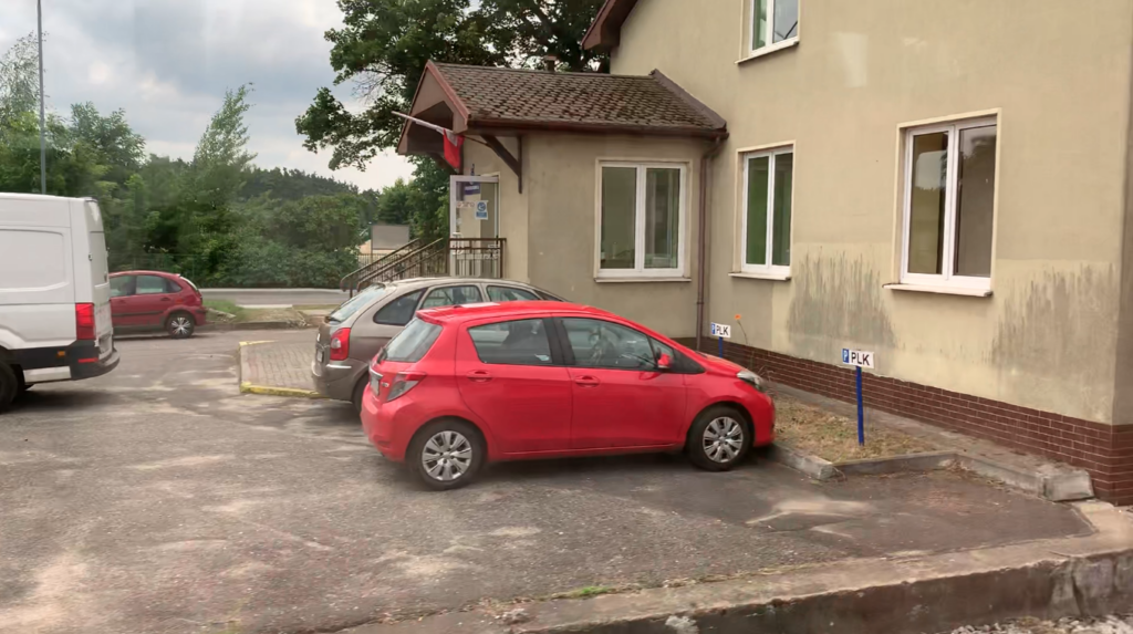
City of Rzepin.
Rzepin is a small town in the Lubusz Voivodeship, in Słubice County. The city is the seat of the Rzepin urban-rural commune. Geographic coordinates: 52.346N 14.832E. Elevation: 50 m. In 2017, Rzepin had 6,590 inhabitants, and in 2024, 6,355 inhabitants.
Rzepin received its charter in 1329. The stronghold was founded in the 10th century on the east-west trade route. It was a convenient location for crossing the Ilanka River and its marshy areas. Craft workshops were established in the area surrounding the stronghold. In the 10th and 11th centuries, these lands belonged to the Piast dynasty, and in the 13th century, to the Silesian dukes. They were then transferred to the margraves of Brandenburg. The stronghold was well fortified with earthen and wooden ramparts. There was also a moat. Furthermore, the marshy areas facilitated defense. The surrounding forests provided building materials and game. The stronghold had two, and later three, gates. The stronghold developed into a center of trade. Almost from the outset, the stronghold had the privilege of brewing beer, fishing, and hunting game. During the Middle Ages, Rzepin’s fortunes were highly volatile. The town was sold several times and even confiscated.
The first Catholic church, built in the 13th century, is now the oldest monument in Rzepin. During the Reformation, the parish was taken over by the Lutherans. In 1860, the church was rebuilt, and in 1879, it was dedicated to St. Catherine. The church is made of stone and brick, and the walls show the stages of its expansion. Until 1945, the church was a Protestant congregation. Rzepin had approximately 500 Catholics. In 1934, on the western edge of town, the Catholics built a Catholic church dedicated to the Sacred Heart of Jesus. In 1945, after the Polish population had settled there, the State Provisional Administration transferred St. Catherine’s Church to the Roman Catholic parish in Rzepin on October 29, 1945. As a result, the Church of the Sacred Heart of Jesus served as a funeral chapel. This church was expanded between 1985 and 1995. On the day of its consecration, the titles of the two Rzepin churches were exchanged. As a result, the branch church became a parish church.
In the 18th century, after a fire, the town of Rzepin was redesigned, with a rectangular plan measuring approximately 300 x 400 meters. The streets were laid out in a grid pattern. A new central market square was laid out. Construction of only brick houses was mandated.
As early as the 18th century, the moat was filled in and gardens, vegetable gardens, and flower beds were planted. This created a green ring around the town. In the 19th century, the first small manufacturing plants began to emerge in Rzepin, providing employment for the local population. A brewery, butcher shops, bakeries, a shoe factory, a cloth factory, and a sewing factory developed. In 1881, the first hospital was built.
Rzepin was not spared from war. The town suffered particularly severe damage during the Thirty Years’ and Seven Years’ Wars. There were also plagues, epidemics, and fires. In 1910, Rzepin had 4,530 inhabitants, and in 1939, 6,444. During World War II, Rzepin was not severely damaged. The Old Town, in particular, was preserved in good condition. The Soviets captured the town on February 2, 1945. The next day, Germanic people passed through Rzepin, heading towards Berlin. Soviet soldiers shot the men, and raped and killed the women. Probably in July 1945, the Muscovites handed the town over to Polish administration.
The paved road to Frankfurt (Oder), which had fueled Rzepin’s development in the early 19th century, became a nuisance for the town in the second half of the 20th century. In 1976, a bypass was built around the city. On December 1, 2011, the 106 km section of the A2 motorway between Nowy Tomyśl and Świecko was opened. Until May 21, 2012, this section was toll-free. The motorway made access to and from Rzepin even easier, but at the same time, travelers and tourists began to avoid the city.
Rzepin Railway Station.
Geographic coordinates: 52.350N 14.815E, elevation 67 m. Address: Dworcowa Street 78, 69-110 Rzepin, Poland.
At the beginning of the 19th century, a paved road ran through the town of Rzepin from Berlin via Frankfurt (Oder) to Poznań. By the mid-19th century, railway plans had already begun. In 1869, the Frankfurt (Oder)–Rzepin–Poznań railway line was built. The railway brought dynamic development to the town, especially since a railway junction was quickly established there. Since the railway station was located west of the town, the town began to move closer to it. Apartments for railway workers’ families, inexpensive hotels for travelers, warehouses and storage facilities for goods, restaurants, and inns were built here.
By 1874, Rzepin had become a railway junction thanks to the construction of a line from Wrocław (Nadodrzanka), extended north to Kostrzyn nad Odrą in 1875. In 1890, the Rzepin–Ośno Lubuskie–Sulęcin–Międzyrzecz railway line was built.
In 1926, new land was parceled out north of the town. Currently, it lies between Juliusza Słowackiego Street and along the railway line to Międzyrzecz. The houses here are primarily built by railway workers.
The Rzepin railway station is the first major railway station in Poland from the west, on the crucial E20 railway route (railway line no. 3). Therefore, a Customs Office was established here, which was a major Polish institution, and in 2004, after Poland joined the European Union, it was renamed the Customs Chamber.
After World War II, the railway junction also expanded. The line from Wrocław to Szczecin was expanded and, following the construction of the Dolna Odra power plant, it was transformed into the Nadodrzańska Trunk Line (Nadodrzańska Trunk Line). This development led to the increased importance of the Rzepin railway junction.
In 1984, a railway bypass for the town of Rzepin was built on the trunk line to relieve the station of freight traffic, primarily hard coal.
Rzepin railway station opened on June 26, 1870. Throughout its history, the station was named Reppen (1870–1945), then Rypin Lubuski (1945–1946), and since 1946, Rzepin. Geographic coordinates: 52.349N 14.815E. In 2019, Rzepin station served approximately 950 passengers. Rzepin Station is located east-west. The eastern section is a passenger station, and the western section is a freight station.
Railway Lines:
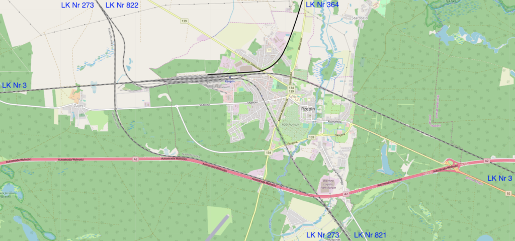
Railway Line No. 3 Warszawa Zachodnia – Kunowice is a section of the E20 route. The line is double-track and electrified. Line No. 3 is 475.583 km long. Maximum speed in sections is up to 160 km/h.
Railway Line No. 364 Rzepin – Wierzbno is a single-track line, 88.992 km long. Passenger service on this line was suspended in 1995. Passenger service on the Rzepin – Międzyrzecz route resumed on December 9, 2007. The route was serviced by rail buses. This service was suspended and reinstated several times. The last closure occurred on December 15, 2013. Currently, the line serves only freight trains.
LK No. 364 Rzepin – Wierzbno begins at Rzepin station at Platform 2 and runs eastward. There is a level crossing; DW No. 139, Juliusza Słowackiego Street. The line turns northward. Then there is a level crossing; Elizy Orzeszkowej Street. The line runs along DW No. 134, which is on the eastern side. The line runs through forests. There is another level crossing; a forest road and another level crossing. DW No. 134 branches off the line eastward. The line leaves and passes under DW No. 137. There is a station in Ośno Lubuskie. There are two road crossings: Bolesława Chrobrego Street and Sulęcińska Street. The line then turns east and passes under DW No. 134. The line re-enters the forest and runs along DW No. 137, which is on the southern side. Then there is a level crossing; DW No. 137, which crosses to the northern side of the line. The line turns south. There’s a stop in Smogory, a small village. The line turns east. The stop is Długoszyn. The line crosses a local road and Voivodeship Roads No. 137 and 138. The line crosses the Postomia River. There’s a station in Sulęcin. The line changes direction several times, but generally heads east. There are level crossings: Lipowa Boczna Street, Lipowa Street. The line re-enters the forest. The line passes through the Red Stream Valley Reserve. On the north side, the line passes Lake Postomsko. There’s a level crossing: Voivodeship Road No. 136. There’s a station in Trzemeszno Lubuskie. Behind the station, there’s a level crossing: Voivodeship Road No. 137, Poznańska Street. There are two level crossings. There are agricultural and wasteland areas. The line re-enters the forest. Nearby, on the north side, is Voivodeship Road No. 137. The line crosses Voivodeship Road No. 137. There’s a Templewo passenger stop. Before the platform, there’s a local road crossing. The Kursko passenger stop. At the stop, there’s a local road crossing. Further on, the line passes under a local road. The line enters the forest again and bypasses numerous lakes. Górzyca is a passenger stop in the middle of the forest. The line crosses the Obra River. The line enters the town of Międzyrzecz. There are several level crossings, and the line passes under the S3 motorway. The railway line from Gorzów Wielkopolski joins the line from the north. The line crosses the Obra River. Międzyrzecz is a large junction station. There are three platforms and five platform edges. After the station, the line crosses the DW No. 137 crossing and splits in three directions. The line runs eastward. Further on, there’s a local road crossing. Beyond the town, there’s a crossing; DW No. 137. The Bobrowicko passenger stop. Next, there’s a local road crossing. Bobrowicko is a small village. The line enters the forest again. Policko is a passenger stop. Policko is a small village. The line crosses the Obra River again. The line enters the forest again. Pszczew is a passenger stop, a former station. Przszczew is a small village nestled between lakes and forests, known for the Pszczewski Landscape Park. The line crosses three local streets. The line turns north. There are farmland, meadows, and forests. Zielomyśl was a passenger stop. From the west, the line is joined by a single-track line from Skwierzyna, Wierzbno station. Beyond the station, the line crosses national road no. 24, and a little further on, the Wierzbno Expedition Terminal and the end of the line. Formerly, the line led to Międzychód.
Railway line No. 821 Rzepin – Jerzmanice Lubuskie is a section of the original “Nadodrzanka” (Nadodrzanka) line, heading towards Wrocław. The line is single-track and electrified. The second section is line No. 822 Rzepin – Drzeńsko, a branch line, heading towards Szczecin. This line is also single-track and electrified. The line passes over a viaduct over route No. 3, ensuring a grade-separated connection. In the 19th century, the track layout was simpler, and the route from Szczecin reached Rzepin station from the north.
Railway line No. 822 Rzepin – Drzeńsko is a section of the original “Nadodrzanka” line, heading towards Szczecin.
From Rzepin station, there were and still are several sidings to local factories and workplaces. There is a siding to the PKP Energetyka SA Zakład Zachodni plant. Another siding leads to the Steinpol furniture factory. The sidings are also used by SKAT Transport.
Rzepin Station Platforms.
The passenger station has five platforms. Platforms 1 and 2 are located on the east-west route, railway line No. 3 (E20), on the north side of the station. Platforms 1 and 2 were renovated between 2011 and 2015. Platform 1 is located next to the station building and has a single edge. Platform 1 is 400 meters long, accommodating the longest passenger trains in Poland. On the western side of the platform is a platform berth for locomotives. Platform 2 is an island platform with two edges. The southern edge is 400 meters long, but the northern edge is only 200 meters long, as it is designed to accommodate regional trains. Access to Platform 2 is via an underpass.
Platform 3 (2A) was removed from service following the station’s modernization. This platform was assigned to the Wierzbno – Międzyrzecz – Rzepin railway line no. 364. Platform 3 (2A) is located in the northern part of the freight station. It was a double-edged platform, approximately 400 meters long. The streetlights and the paving slab surface remained, but these were gradually becoming overgrown with moss and grass. Access to Platform 3 (2A) was from Platforms 1 and 2 via the tracks. Platforms 4 and 5 are located on the southern side of the station, on the so-called “Nadodrzanka” line. The platforms were renovated between 2017 and 2019. Sections of the trackbed, sleepers, and rails were replaced. The traffic control traffic lights were replaced, and their surface was resurfaced. New benches, shelters, lighting, sound systems, information boards, and landscaping were installed. The platforms are accessible to people with disabilities.
Platform 5 lacks an underpass, so access to the platform is at track level. This passage is secured with automatic barriers for train passage. A modern monitoring system also ensures safety. Platform 4 is a single-edge platform adjacent to the station building.
Platform 4 is only 140 meters long and is designed for regional trains. Platform 4 features a locomotive parking berth. Platform 5, an island platform, is 400 meters long and is designed for long-distance trains on the Wrocław-Szczecin route. A freight ramp is located south of Platform 5.
Although individual platforms are designated for specific routes, trains can pass in other directions, either in front of or behind the platforms.
In the southern part of Rzepin station, there is another double-edged platform, impassable. Currently (2022), the former platform is owned by a private company. The shelter above the platform has been renovated and has a new roof. The platform was 300 meters long. It is possible that the platform was intended to be the starting point of a new railway line towards Cybianka. A vulcanization plant is also located here.
Rzepin Station Infrastructure.
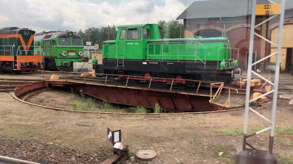
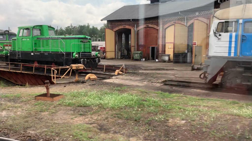
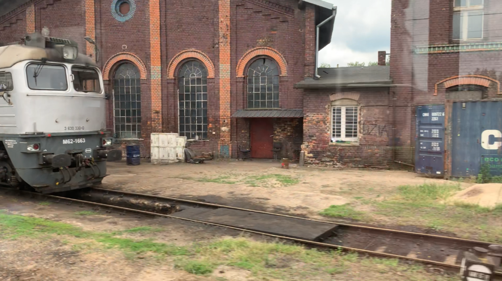
The locomotive shed was built around 1880 and included a fan-shaped shed, a water tower, coaling facilities for steam locomotives, and technical buildings. The water tower is in poor condition and no longer has a roof. The shed was unused for the 1990s, but since around 2010, it has once again been used to service locomotives of private rail operators. The station grounds house the Passenger Transport Section, specifically Przewozy Regionalne Sp. z o.o., Lubuski Branch in Zielona Góra. Rzepin station houses a Railway Protection Guard (SOK) station. Until December 2007, the station in Rzepin served as the border crossing between Rzepin and Frankfurt (Oder).
In 2019, city authorities began cleaning up the area near the railway station. Streets and sidewalks were repaired, and storm sewers were installed. A roundabout and parking spaces for 46 passenger cars were constructed in front of the station. Small architectural elements and bicycle racks were installed. New street lighting was installed. The work, valued at approximately 1,800,000 złoty, was completed in June 2020.
The station houses a technical monument: a Polish Ty51-37 steam locomotive. The Ty51 steam locomotive was produced at the HCP plant from 1953 to 1958. The locomotive was the heaviest Polish steam locomotive. The locomotive has been the symbol of Rzepin station since 1991.
Rzepin Station Building.
The Rzepin station is one of eight buildings in the Lubuskie Voivodeship covered by the 2016-2023 station investment program. Renovation of the Rzepin station began in early 2022. The work was financed by the city and PKP PLK (Polish State Railways). The work was carried out under the supervision of the conservator. The building’s interior was completely modernized. New ticket offices, a waiting room, a staircase with an elevator, new restrooms, a bar, and more were added. New benches, timetable displays, electronic train arrival and departure boards, and a new voice announcement system were installed inside the station. Everything is accessible to people with disabilities. The building includes elevators, paths for the blind and visually impaired, tactile maps of the station, and Braille signage. Windows and doors were replaced. The roof and exterior facades were also renovated. The skylight in the roof was also renovated. The exterior walls are currently brick, as they appeared on opening day. Plans are underway to establish a PKP museum. Eighteen skylights in the canopies surrounding the station building have been renovated. These canopies are supported by decorative cast-iron pillars. The station received a new electrical system and new lighting. The station is equipped with a security and monitoring system. The cost of reconstructing the Rzepin station is PLN 12.6 million gross. The construction contractor is LK Inwest from Wrocław, and the design documentation was prepared by the architectural studio PAS Projekt from Nadarzyn.
Rzepin Freight Station.
The freight station has 22 tracks. The station, including the headers, is 875 meters long and can accommodate freight trains up to 625 meters long, equivalent to 42 typical freight wagons. Rzepin also has a container depot. This is where containers are transferred from trains to trucks and vice versa.
The electrification of the Rzepin junction was completed in 1988, but railway line No. 364 Rzepin-Wierzbno was not. Until recently, the Rzepin station had four signal boxes: RzA, RzB, RzB11, and RzB12. Until 1991, the station had shape signals. The RzA signal box was the first to be modernized. At the beginning of the 21st century, a computer system was gradually introduced.
There are no problems on electrified routes. These are served by EMUs, of which there are many in Poland.
The situation is much worse on non-electrified lines. Railbuses and DMUs are used here: SA105, SA133, SA139, and SA140. These trains are few in number. Furthermore, mandatory inspections made maintaining the route network difficult. It’s important to remember that these trains operated on technically challenging routes, with few straight sections of track. This causes wheel sets to wear out faster. Furthermore, trains frequently traverse road and rail crossings, where inattentive drivers are not uncommon. This leads to accidents and train damage. As a result, trains are sent for repairs, which take a long time. This is due to a lack of spare parts in warehouses. Since the front ends of all new trains are made of composite materials, they must be ordered.
Written by Karol Placha Hetman