Rudna Gwizdanów 2025-05-19
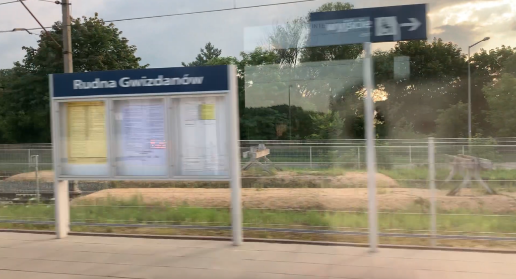
Rudna Gwizdanów Railway Station.
Geographic coordinates: 51.530N 16.280E. Elevation 103 m. Address: Gwizdanów, 59-305 Rudna.
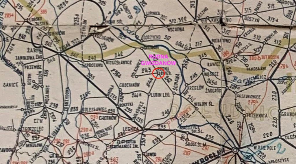
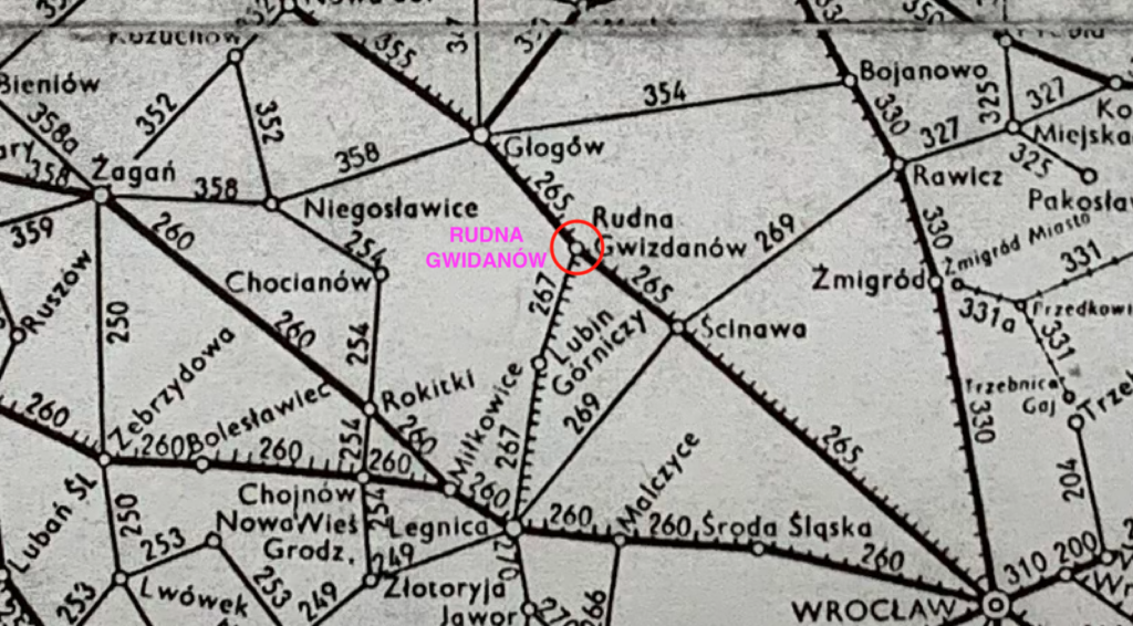
The station is located on the Legnica – Głogów railway route and was built in 1871, i.e. in Prussian times. Currently, it is the Lower Silesian Voivodeship, the town of Gwizdanów, the Rudna commune. Previous names: Raudten (1871), Raudten Queissen (1935-1945), Gwizdanów (1945-1947), Rudna Gwizdanów (since 1947). In 1874, a railway line was built directly from Wrocław. In this way, the Gwizdanów station became a junction station. In 1900, a railway line was built to Polkowice, which was dismantled in 1974.
Gwizdanów is a town whose history dates back to the Middle Ages. Initially, the town was known as Gwizdanovo (1265). This name comes from the Polish word “gwizdać”, or possibly from the surname Gwizdan. Later, under the influence of Germanization, the town was called Queisen, and then Queiβen. After World War II, the old form Gwizdanów was restored.
In 1289, in a document of the Wrocław bishop Tomasz, the parish priest of Gwizdanów, Father Wenzeslaus, was mentioned for the first time. At that time, the village was church property and was managed by the Wrocław bishop. The village was church property until the secularization of Prussia in 1810, when the village was taken over by the royal treasury. The current church in Gwizdanów was built in the Middle Ages and was always dedicated to Saint Ursula (1372). The church was rebuilt several times. As a result of the Reformation, it was an evangelical church, until 1945, when it became a Catholic church again. The parish cemetery is the burial place of: Catholics, evangelicals and Orthodox. The Orthodox were Polish people who were expelled from the Polish Borderlands as part of the “Vistula” campaign.
In 2022, the population of the village of Gwizdanów was 398 people. The area of the village of Rudna is located at an elevation of 90-110 m. The terrain was shaped by the second glaciation. The village has an irregular shape, characterized by loose and scattered development. The village is typically agricultural, but many residents work in the copper industry. The Rudna River flows through the western area of the village, parallel to the railway line. At a greater distance, the village is surrounded by small forests. The establishment of the Copper Mining and Metallurgy Combine and the construction of mines in Lubin and Polkowice caused a change in the structure of the residents’ sources of income. Many residents took up work in the industry, and then changed their places of residence and moved to nearby Lubin. Nearby is the “Żelazny Most” facility, where industrial waste is collected.
In the 18th and 19th centuries, in the area of today’s Rudna commune (Lower Silesian Voivodeship) and its surroundings, many residences, palaces and manor houses were built, belonging to the aristocracy and landed gentry, including people associated with Wrocław, which was the capital of Silesia and an important political and cultural centre. At that time, the custom of building summer residences outside the city developed, often in picturesque regions of Lower Silesia, such as the Rudno area. Lower Silesia was densely dotted with landed estates with palaces and manor houses. To this day, it is referred to as the “country of palaces and gardens”. In the 19th century, summer residences built away from the hustle and bustle of the city, surrounded by landscape parks, became fashionable. Many of them were located within a radius of several dozen kilometres from Wrocław. In the region of the Rudna commune (for example the villages of Chobienia, Naroczyce, Wysokie, Gawrony, Studzionki) there were palaces and manors, some of which were built or rebuilt in the 18th–19th centuries. Examples: Palace in Chobienia – Renaissance, later rebuilt; known as one of the residences of regional importance. Palace in Gawrony – Classicist palace from the 19th century.
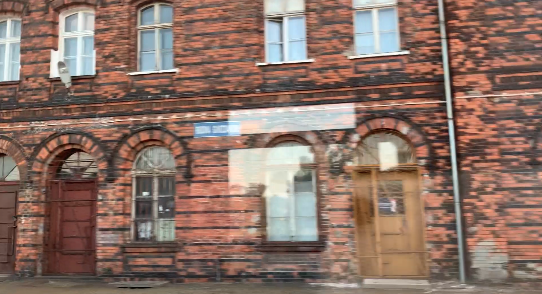
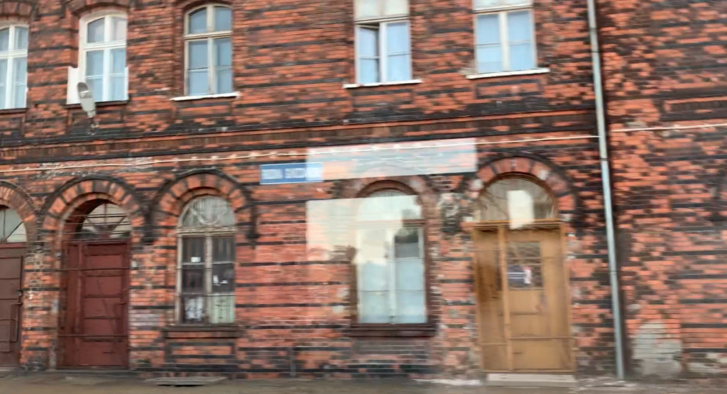
This addition is necessary to explain why a representative railway station was built in such a small town. The aristocracy contributed to the construction of the station, in order to make it easier for them to travel from Wrocław to their leisure time. The station was built according to a typical design and there were several such stations in Lower Silesia. The station in Zielona Góra (Grünberg) was similar, but it no longer exists. The station building represents a typical Prussian railway architecture form from the second half of the 19th century, which has a functional form, with elements of the neo-Renaissance style. The layout of the building is characteristic, in which, in addition to the main hall with ticket offices, there was a huge representative restaurant-waiting room, with huge windows to the east and west. Additionally, in the southern part of the building, there was the so-called imperial room, for the most important guests-travellers. Such rooms were at almost all Prussian stations, for example Toruń, Piła. The station has two storeys with a partially developed attic. The building is built on a plan close to a rectangle, with dimensions of 64 m x 20 m. The building consists of four blocks. Looking from the south, there were: 1; the emperor’s room, the restaurant kitchen, the restaurateur’s apartment. 2; the restaurant and waiting room at the same time. 3; the main entrance from the station level and the station square, ticket and luggage offices, railway service rooms, the station master’s apartment. 4; railway service rooms, forwarding, telephone and post office. The building was built of red and black brick, in such a way as to create a decorative pattern. The window frames, arches above the windows, cornices, projections with pilasters are decorative. Everything is made of brick. The individual blocks of the station were covered with gable roofs with a small slope. The station building is historic and is currently inaccessible to passengers. There are no ticket offices or waiting rooms. The building is inhabited by railway families. Currently (2025), the station building no longer serves its original function, but has retained many original architectural elements, such as wooden ceilings, stairs, window frames and doors.
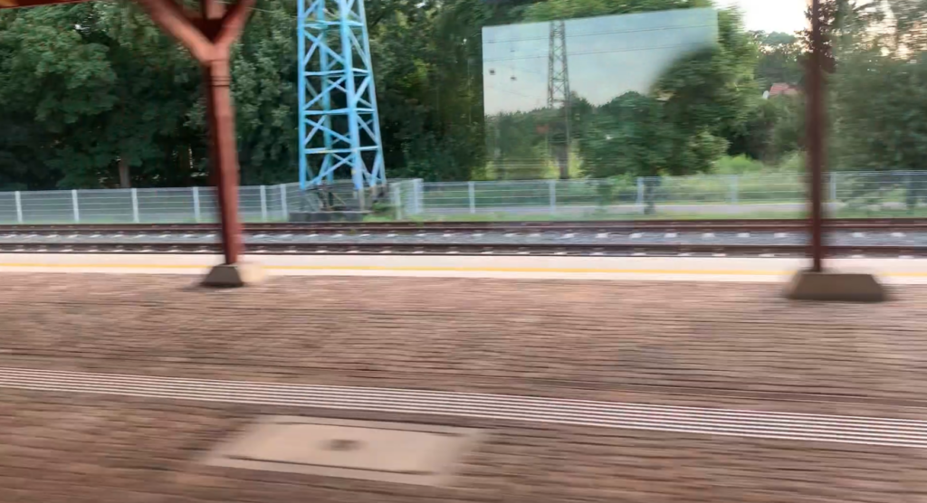
Platform 1 is an island platform and has two platform edges, but the track on the western side is an impassable track with a stop trestle. There is a historic wooden shelter on the platform, which was built of wood and is in good condition. The shelter is 100 m long and the surface under it is made of historic basalt blocks. The rest of the platform, in 2017, received a concrete block surface, and the edges were made of 1 m x 2 m concrete slabs. These slabs have buttons and yellow warning lines. The current Platform 1 is 220 m long. Platform 2 is an island platform, but has a single edge and is narrow. The platform is 280 m long.
Trains to Polkowice station, in the post-war period, departed from track No. 4 at Platform 1. Here, the tracks are impassable. There are three tracks here. One track at Platform 1, the second is a rotating track for locomotives, and the third is a storage and haulage track. Behind the access road to the station, there was another track, which was also used for passenger trains to Polkowice. Passengers boarded from the street. This was the beginning of the railway line to Polkowice (0.000 km).
In the southern head of the station, above the tracks, there is a metal viaduct along DW No. 323. The viaduct was built around 1900 and replaced a rail-road crossing. The viaduct has one rectangular truss span and is riveted. The span is 53 m long. During the last renovation, the viaduct received side sidewalks. The roadway is asphalt. The maximum height of vehicles cannot exceed 3.8 m. Provincial road No. 323 is a 64 km long provincial road connecting DW No. 309 in Leszno with DW No. 333 in Szklary Górne near Lubin.
In the history of the station, there was no passenger tunnel or footbridge over the tracks. There was also a water tower, which stood in the northern head of the station. The station had a three-station locomotive shed with a turntable. The building was demolished, but the turntable remained. Shape semaphores were replaced with light semaphores only in 2019. On the southern side, there is only the “RG” signal box. The “RG1” executive signal box on the northern side was liquidated. In September 2015, the Zakłady Usługowe Południe company, a company separated from PKP, demolished the fan-shaped locomotive shed and a number of buildings located between the station and the locomotive shed. The water tower and pumping station (unused since 1998) were dismantled much earlier, around 2012. The station had a 40-ton wagon scale, which was used until 1991.
The station was electrified with 3 kV DC by August 30, 1986. The main load-bearing poles placed on both sides of the station level were used for electrification. The poles are lattice-framed and are currently painted blue.
Railway lines: LK No. 273 Wrocław Główny – Szczecin Główny (77.651 km of line). LK No. 289 Legnica – Rudna Gwizdanów (39.39 km of line). Industrial LK Rudna Gwizdanów – Huta Miedzi Cedynia, this is a single-track non-electrified line. LK Rudna Gwizdanów – Polkowice. In passenger traffic it was used in the period 1900–1969, and in 1974, the line was dismantled. It is worth adding that the LK Ścinawa – Rudna Gwizdanów initially had a different route. It ran more straight, meridionally and did not pass through the Rudna Miasto station.
Currently (2024) passenger traffic does not exceed 100 people per day. Only Koleje Dolnośląskie trains stop at the station. During the day, as many as 50 trains stop at the station. You could go to the following stations: Wrocław Główny, Głogów, Zielona Góra Główna, Legnica. There is also a stop Rudna Miasto nearby.
Written by Karol Placha Hetman