Piotrków Trybunalski. 2023-07-07
Piotrków Trybunalski Railway Station.
Geographic coordinates: 51.411N 19.684E. Elevation 203 m (666 ft).

Piotrków Trybunalski.
Piotrków Trybunalski is a city in central Poland. After World War II, the word “Trybunalski” was added to the name Piotrków to emphasize the rich and beautiful history of Polish parliamentarism and democracy, as the Crown Tribunal was located here. Piotrków Trybunalski boasts one of the most beautiful courthouses in Europe. Piotrków Trybunalski lies in the Łódź Voivodeship and is a city with county rights. The city has an area of 67.3 square kilometers (26.3 square miles). The population is 67,734 (2022).
The city of Piotrków Trybunalski is located in the southeastern part of the Łódź Voivodeship on the Strawa River. Historically, it belongs to the Sieradz Land, which beautifully connected the Lesser Poland, Greater Poland, and Masovia regions. Piotrków Trybunalski is 46 km from Łódź, 90 km from Częstochowa, 145 km from Warsaw, 170 km from Krakow, and 245 km from Poznań.
History of Piotrków Trybunalski.
The settlement was founded in the 8th century. The town was granted city rights between 1290 and 1300. Unfortunately, the first municipal documents of Piotrków Trybunalski were destroyed around 1400, when a great fire destroyed the town. In the 16th century, Piotrków was a royal town belonging to the Sieradzki Voivodeship. From 1975 to 1998, the town was the capital of the Piotrków Voivodeship. From the 13th century, documents referred to the town as Piotrków, Pietrków, or Piotrkowo. The name derives from the name Piotr.
In 1217, in a document issued by Leszek the White for the Cistercian Order in Sulejów, the name Piotrków is first mentioned. In 1313, Władysław the Elbow-high designated Piotrków as a town. In 1346, the Statutes of Piotrków were written, and the town became the seat of the nobility’s courts, both land and municipal. From 1442, synods of the Roman Catholic Church, the Gniezno Province, were held in Piotrków. In 1467, the Peace of Thorn was ratified in Piotrków. In 1468, the first general parliament of the Kingdom of Poland was held. On December 1, 1469, at the parliament, Grand Master Henry Reuss von Plauen of Prussia paid homage to Casimir IV Jagiellon. In 1492, John Albert was elected. In 1493, the parliament was divided into a Chamber of Deputies and a Senate. In 1578, the Crown Tribunal for Greater Poland was established. The town developed rapidly. Many inns and taverns were built. Horse breeding was widespread, and crafts flourished.
Natural disasters and the consequences of the wars with Sweden brought about Piotrków’s decline. A great fire in September 1786 destroyed the Baroque buildings of the Old Town, which, rebuilt in the early 19th century, retained only its medieval urban layout and historic churches. The city’s former splendor was preserved by schools run by the Jesuit and Piarist orders, where they cultivated not only the Catholic faith but also parliamentarism and democracy, effectively opposing the harmful Reformation. In 1793, the Second Partition of the Polish-Lithuanian Commonwealth took place, and Piotrków was incorporated into the Prussian partition. In 1807, Piotrków was incorporated into the Duchy of Warsaw, and in 1815, into the Kingdom of Poland, which was completely controlled by the Muscovites.
On September 2, 1846, the first train departed from Piotrków station towards Warsaw. The construction of the railway line significantly influenced the city’s development. A new, modern center was established between the old town and the railway station. Within a few years, the city’s population grew to 40,000 inhabitants. New factories and craft workshops were established.
In 1914, with the outbreak of the Great War, the city changed hands several times between Prussia and the Muscovites, until in December 1914, Piotrków was finally occupied by Austria-Hungary. From November 2-5, 1918, the Poles disarmed the Austrian occupiers. The Republic of Poland regained its independence.
On September 1, 1939, Germans, along with Muscovites, invaded Poland once again. From September 2-4, 1939, Piotrków was subjected to constant bombardment. Approximately 200 residential buildings were destroyed. On September 5, 1939, the German occupation began. German brutality against Polish citizens was widespread. The first ghetto for Polish citizens was established there. On October 26, 1939, the Germans incorporated Piotrków into the General Government, a state whose goal was to eliminate the Polish nation. On January 18, 1945, the Muscovites entered Piotrków, and the Soviet occupation began. Poland was organized along the lines of the CCCP. Soviet troops remained in Poland until 1993, but Soviet agents remain to this day.
The Warsaw-Vienna Railway.
The Warsaw-Vienna Railway was built between 1840 and 1848 and was one of the first railway routes in the occupied (partitioned) Republic of Poland. The route was 310,400 km long and connected Warsaw – Piotrków – Częstochowa – Granica (now Maczki), in the Three Emperors’ Corner. That is, to the border with Galicia (Austrian partition). The line then ran through Mysłowice (in the Prussian partition) and on to Vienna. In the other direction, the line ran to Kraków and on to Lviv. The railway line was managed by the Warsaw-Vienna Railway Company. Importantly, the line was built with a 1435 mm gauge. The line was built during the Muscovite occupation and was called the Warsaw-Vienna Iron Road, or in Polish, the Warsaw-Vienna Iron Road. The route was the first railway line in the then Kingdom of Poland and the second in the Muscovite Empire (the evil empire). Muscovites approached the railways from the perspective of military use, as they had never been interested in economic development and the prosperity of their inhabitants. Polish industrialists, who desired good connections with other industrial centers, were involved in the development of the line.
The Corner of the Three Emperors.
The Corner of the Three Emperors, or rather, three imperial countries with barbaric inclinations towards other nations: Prussia (Germanic), Austria (later Austria-Hungary), and the Muscovites (Russia). This term was used in the period 1846 – 1915, but in Polish it was called “Wychodek Cesarzy”.
The first important border changes in this area occurred in 1742, when, as a result of the Prussian-Austrian War, a large part of Silesia passed from Austria to Prussia. At that time, the Czarna Przemsza River became the border separating Prussia from the Duchy of Siewierz, which was a Polish fiefdom. From 1790, after the Duchy of Siewierz was united with Polish lands, it was the border with the Republic of Poland. This changed during the Third Partition of Poland, when the entire area fell under Prussian rule. The borders of the three imperial powers converged near the town of Niemirów between 1795 and 1807, i.e., from the Third Partition of Poland to the creation of the Duchy of Warsaw. The Czarna Przemsza River was established in 1807, following the Peace of Tilsit. In the period 1815–1831, following the Congress of Vienna (Dancing Congress), the borders of the Congress Kingdom, Prussia, and the Republic of Kraków converged here. From 1831–1846, after the incorporation of the Kingdom of Poland into the Muscovite state as an autonomous province, it was the meeting point of the borders of the Muscovite state (Russia), the Germanic state (Prussia), and the Republic of Kraków. Subsequently, after the latter’s incorporation into the Austrian Empire, from 1846–1871, the borders between the Kingdom of Prussia, the Austrian Empire (from 1867, Austria-Hungary), and the Muscovite Empire converged here.
The name “Triangle of the Three Emperors” (Kąt (Triangle) of the Three Emperors” arose after 1871, when the Germanic states united, and this place, while still on the border of the Kingdom of Prussia, simultaneously became a border point of the German Empire. The border lines ran along the Biała Przemsza, Czarna Przemsza, and Przemsza rivers. The border ceased to exist at this point in 1915, when the imperial powers took sides, leading to the outbreak of the Great World War, and the “Three Emperors’ Outhouse” ceased to exist. This entire area was reincorporated into the reborn Polish Republic.
Mysłowice Railway Station.
In 1836, at the initiative of industrialists and merchants, the Upper Silesian Railway Company (TKG) was founded. The main goal of the TKG was to connect Upper Silesia with Wrocław by rail. In 1841, the Oberschlesische Eisenbahn Aktien Gesellschaft company was established, which in the following years built a standard-gauge railway from Wrocław to Mysłowice. Individual sections of the railway were built in different locations, and only eventually a single line was created.
In 1846, the railway was extended to Mysłowice. A further goal was to connect Upper Silesia with Kraków, thus overtaking the Austrians in this investment and reaping the financial benefits of the transport. The main goods were hard coal, iron products, and the benefits of relatively cheap rail transport. Almost all of the railway lines were built by private companies, which received numerous legal advantages that emerged in the Kingdom of Prussia. Among other things, it facilitated the acquisition of land for railway lines and offered numerous tax breaks. The government of the Kingdom of Prussia strongly supported the development of rail transport. Rail transport of troops and their supplies emerged somewhat later, as the military initially perceived the threat of a swift surprise attack in railways. The military demanded that important military installations be bypassed by railway lines. This view was strongly supported by Moscow. The nationalization of the railways in Prussia sparked the military’s interest in this mode of transport.
Work on the Wrocław-Mysłowice line (a border town of the Kingdom of Prussia) and simultaneously in Mysłowice had been underway since 1842. On October 1, 1946, the railway station in Mysłowice officially opened, and residents saw the first train. King Frederick William IV of Prussia was present at the ceremony. The station was a terminus, with only two tracks and a turntable for steam locomotives. At the time, the station was called Myslowitz, but the names Mysłowice Główne and Mysłowice Miasto were also used.
On the other side of the border, in Galicia (Austrian Partition), the Kraków-Upper Silesian Company was building railways. In October 1847, the two lines were connected. As a result, the entire line from Kraków to Wrocław could be traversed. Communication between the stations was provided by telegraphy and a so-called scepter train.
The Prussian authorities sought to build a railway line from Mysłowice to Sosnowiec, Zawiercie, and other towns. But Moscow was not interested in this plan, suspecting a ruse. In 1856, a railway line was built from Mysłowice to Oświęcim. Mysłowice flourished, but other regions of Upper Silesia developed even more dynamically, including the newly founded Katowice.
Mysłowice became a tourist destination, visited by people eager to see where the borders of three powerful empires met: the Germanic, the Austro-Hungarian, and the Muscovite. To the Poles, they were merely invaders.
Mysłowice stały się także ważnym ośrodkiem dla emigrantów. Do Mysłowic przyjeżdżali People who wanted to emigrate from Galicia and the Kingdom of Poland to America. In Mysłowice, the Germans established an emigration office that issued special documents. Emigrants purchased train tickets from Mysłowice via Gliwice, Wrocław, and Berlin to Hamburg. In Hamburg, the emigrants transferred to ocean-going ships and sailed to America.
The Warsaw-Granary (Mączki) Line.
This clearly illustrates the significant impact the construction of railway lines had on economic development. Remember that a horse can pull a cart with goods weighing up to 1,500 kg. However, a horse can pull a rail wagon with goods weighing 3,000-5,000 kg. According to estimates, a 10-kilometer narrow-gauge line replaced the work of 100 horse-drawn carriages. Transport costs were reduced by 50-60%.
The technical design for the line was developed as early as 1835. Engineer Stanisław Wysocki was the designer of the route. In 1838, the Warsaw-Vienna Railway Company was established. Initial construction work began in 1840 on the Warsaw-Skierniewice section. Horse-drawn and steam traction were considered simultaneously. In 1841, steam traction was ultimately selected as more efficient, along with a 1435 mm rail gauge.
However, in November 1841, work was suspended due to a lack of sufficient funds, and in May 1842, the Warsaw-Vienna Railway Company declared bankruptcy. On July 4, 1843, the government of the Kingdom of Poland established the Warsaw-Vienna Railway Authority, and in 1844, the Russian Imperial Loan Bank (Bank Polski) began financing the work. In November 1844, the Warsaw-Pruszków section was opened. On November 28, 1844, the first official train, carrying the Governor of the Kingdom of Poland, the bandit Ivan Paskevich, and invited guests, traveled along this section.
The next railway section, Pruszków-Grodzisk Mazowiecki, was opened on June 14, 1845.
The Vienna Railway Station was built in Warsaw and completed in 1845. The station has not survived to this day (2023). The “Centrum” metro station currently stands in its place.
At that time, work was already underway on the remaining sections of the route. On October 15, 1845, the line was extended to Skierniewice and Łowicz. On September 2, 1846, the first train departed from Piotrków station towards Warsaw. Literature records indicate that the first train from Piotrków departed in November 1846. It was the train carrying the governor of the Kingdom of Poland, the bandit Ivan Paskevich, as recorded in the chronicles. However, this was not the first train in Piotrków.
On December 1, 1846, the section to Częstochowa was completed, and on April 1, 1848, the first train reached the Granica station (Maczki, now a district of Sosnowiec).
Twenty-seven stations were built along the route. At the time, it was the longest railway line in Europe—310.396 km—built by a single company. From October 1, 1848, rail travel was possible from Warsaw to Krakow, Wrocław, and Bohumín. Travel to Vienna was possible from 1856.
Already in its early years, the line received its first branches. In 1859, the first Ząbkowice-Sosnowiec connection opened, directly connecting the Kingdom of Poland with Prussia (not via Galicia). In 1862, the Łowicz-Aleksandrów Kujawski connection opened. In 1865, another private company built the Koluszki-Łódź (now Łódź Fabryczna) connection.
The line generated good revenue, which allowed for infrastructure modernization. Pine sleepers were replaced with oak ones, and iron rails with steel rails. This allowed for the use of heavier locomotives and trains. The first wood-fired locomotives were replaced with coal-fired locomotives, which were heavier and had greater tractive power. The line was used primarily for transporting coal, timber, textiles, and agricultural produce. Between 1860 and 1880, a second track was laid, increasing the route’s capacity and improving travel safety. Until 1857, the railway was operated by the Moscow treasury. Afterward, it was owned by Polish industrialists. In 1912, the Warsaw-Granary route was nationalized by the Moscow authorities. In 1918, after Poland regained independence, the route was incorporated into the newly established Polish State Railways (PKP).
Route: Warsaw – Pruszków – Grodzisk Mazowiecki – Żyrardów (Ruda Guzowska) – Skierniewice – Koluszki – Piotrków Trybunalski – Radomsko – Częstochowa – Poraj – Myszków – Zawiercie – Łazy – Ząbkowice – Strzemieszyce Południowe – Granica (Maczki).
Sections: Skierniewice – Łowicz (connector to the Warsaw-Kaliska Railway). Łowicz – Aleksandrów Kujawski. Koluszki – Łódź Fabryczna (Fabryczna-Łódź Railway). Ząbkowice – Sosnowiec.
Currently (2023), the Warsaw-Vienna route is railway line No. 1, which begins with a switch at Warszawa Zachodnia station, which is a junction station. Railway lines No. 1 are located here; 2, 3, 8, 20, 23, 42, 46, 85, 445, 447, 448, 784, 849, 850, 918, 919. At km 6.804 is the Warszawa Włochy station. At km 8 of the line there is a viaduct, where railway lines No. 3 and 457 run over it. Then there is the Warszawa Ursus passenger stop, and after that the Warszawa Ursus Niedźwiadek passenger stop. Then the railway line passes under national road No. S2 and S8 (Aleja Polskiej Organizacja Wojskowej). Then, from the north, the railway line from Warszawa Gołąbki station joins. Then there is the Piastów railway station. At km 15.891, there is the Pruszków station. Here are railway lines No. 447 and 512. Then there are passenger stops: Parzniew, Brwinów, and Milanówek. At km 29.548, there is the Grodzisk Mazowiecki junction station. Railway lines No. 4 and 447 are located here. Next comes the Jaktorów passenger stop at km 35.032. This is where the Central Railway Main Line (line No. 4) branches off, passing over line No. 1 at km 37.700. Next comes the Międzyborów passenger stop (km 40.468). At km 43.141, there is the Żyrardów station. Next, we cross the Pisa Gągolina River, and after a while, national road No. 50 and the Sucha River. At km 50.033, there is the Sucha Żyrardowska passenger stop. At km 51.959, there is the Jesionka passenger stop. At km 55.404, there is the Radziwiłłów Mazowiecki passenger stop. We cross the Korabiewka River. At km 60.779, there’s a passenger stop at Skierniewice Rawka. This is the end of the straight section of the line from Warsaw itself. At km 62.000, there was a large Miedniewice station, which has since been closed. Lines No. 12 and 529 join here. At km 65.926, there’s a junction station at Skierniewice. Lines No. 11, 12, 529, and 558 join here. We cross the Skierniewka River. Then we have a railway triangle towards Łowicz and Koluszki. Now begins a section of the route that changes direction several times. We pass the Zwierzyniec River and reach the Dąbrowice Skierniewickie passenger stop, km 71.355. The Maków passenger stop, km 75.372. The Płyćwia passenger stop, km 80.131. The Lipce Reymontowskie passenger stop, km 84.710. Only now does the route head decisively south. Krosnowa passenger stop, km 89.822. Przyłęk Duży passenger stop, km 92.345. Rogów station, km 95.723. The Rogów Narrow-Gauge Freight station is also located here. The line crosses national road No. 72. Wągry passenger stop, km 99.610.
Koluszki junction station, 105.194 km. There are numerous junctions here towards Łódź and Tomaszów Mazowiecki. There are railway lines No. 17, 534, 535, 536, 538, and connecting road 537 with a viaduct over line No. 1. There is a viaduct with line No. 25, 107.700 km. Bęzelin station once stood here. Rokiciny passenger stop, 114.176 km. We cross the Wolbórka River. Wolbórka passenger stop, 123.535 km. Baby station, 129.944 km. Rail-road crossing with provincial road No. 716. We cross the Moszczanka River. Moszczenica passenger stop, 133.825 km. Jarosty passenger stop, 138.545 km. We cross the national road (S8, 12, 74, 91), viaduct under the road. Piotrków Trybunalski junction station, 144.242 km. Branch switch of line No. 24, 146.420 km. Milejów passenger stop, 150.389 km. Intersection with national road No. 91. Rozprza station, 156.555 km. Luciążanka passenger stop, 159.433 km. Wilkoszewice passenger stop, 162.533 km. Gorzkowice station, 166.718 km. Gorzędów passenger stop, 171.660 km. Kamieńsk passenger stop, 175.004 km. Crossing with national road No. 91. Gomunice station, 177.694 km. Dobryszyce passenger stop near Radomsko, 183.452 km. Radomsko station, 189.133 km. Crossing with national road No. 42. Crossing the Radomka River. Bobry passenger stop, 194.756 km. Crossing the Warta River. Widzów Teklinów station, 200.525 km. Jacków passenger stop, 202.758 km. Crossing with national road No. 91. Kłomnice station, 208.201 km. Rzerzęczyce passenger stop, 210.606 km. Crossing with national road No. 91. Rudniki station near Częstochowa, 217.700 km. Connecting with railway line No. 146, with a viaduct, 221.963 km. Wyczerpy switches, 222.755 km. Częstochowa Aniołów passenger stop, 225.816 km. Intersection with national road No. 1. Intersection with national road No. 46. Częstochowa Osobowa junction station, 229.745 km. Railway lines Nos. 701 and 703 are here. Częstochowa Towarowa station, 232.527 km. Intersection towards Częstochowa Stradom station. Częstochowa Raków passenger stop, 233.500 km. There are viaducts here with connecting line No. 703 and line No. 61, 235.600 km. Korwinów passenger stop, 239.158 km. We cross the Warta River. Poraj goods station, 245.850 km, and switch of line No. 155. Poraj passenger stop, 246.950 km. Masłońskie Natalin passenger stop, 250.787 km. Żarki-Letnisko passenger stop, 254.088 km. Intersection with provincial road No. 789. Myszków Nowa Wieś passenger stop, 257.525 km. Intersection with provincial road No. 793. Myszków station, 261.016 km. Myszków Światowit passenger stop, 263.442 km. Intersection with railway line No. 4 – Central Railway Line, 265.100 km, but not yet connected by switches. Myszków Mrzygłód passenger stop, 266.370 km. Zawiercie Borowe Pole passenger stop, 270.300 km. Zawiercie junction station, 274.227 km. Switches connecting with line No. 4, 275.093 km. Track switches Nos. 214, 216. Crossing with the road – Poręba and Zawiercie bypass. Łazy freight junction station, 280.654 km. Other railway lines Nos. 154, 160, 186. Łazy passenger station. Wiesiołka passenger stop, 284.313 km. Viaducts with lines Nos. 154 and 160, 265.100 km. Chruszczobród passenger stop, 286.557 km. Intersection with provincial road No. 796. Dąbrowa Górnicza Sikorka passenger stop, 289.202 km. Dąbrowa Górnicza Ząbkowice junction station, 292.896 km. Other railway lines; 183, 133, 160, 186. Intersection with national road S1. Dąbrowa Górnicza Pogoria passenger stop, 295.726 km. Dąbrowa Górnicza Gołonóg passenger stop, 296.726 km. Dąbrowa Górnicza station, 300.267 km. Będzin Ksawera passenger stop, 302.077 km. Intersection with provincial road No. 910. Będzin Miasto passenger stop, 304.385 km. Będzin station, 305.524 km. Intersection with national road No. 94. Sosnowiec Główny junction station, 309.544 km. Other lines Nos. 62, 660. Switches towards Sosnowiec Południowy station. Bridge over the Brynica river, and then a bridge over the Rawa river. Intersection with the railway line to Katowice Szopienice Północne station. Katowice Szopienice Południowe passenger stop, 312.910 km. Intersection with national road No. 79. Katowice Zawodzie junction station, 315.653 km. Intersection with national road No. 86. Katowice junction station, 318.378 km. Final switch 318.686 km. Other lines Nos. 656, 137, 138, 139, 713.
Difference from the original Warsaw – Granica (Mączki) route; Dąbrowa Górnicza Ząbkowice junction station, 292.896 km. Here, the route turns due south. At the Katowice Steelworks, there’s a switch, and the “Wiedeński” route turns east, only to turn south again shortly after. The second branch leads to the Dąbrowa Górnicza Strzemieszyce station. The “Wiedeńska” line intersects with national road No. 94. It then intersects with the Dąbrowa Górnicza Strzemieszyce – Dąbrowa Górnicza Wschodnia railway line. It then crosses the Bobrek River and passes the Sławków Forest. It intersects with the railway switches of the Sławków Euroterminal. It reaches the village of Maczki and reaches the Granica station. This is where goods were transshipped from the Warsaw-Vienna Railway onto Austro-Hungarian Railway trains. When transport was improved and most goods were no longer reloaded, trains crossed the Biała Przemsza River and headed either to Szczakowa station (eastbound, towards Kraków) or to Mysłowice station in the Prussian Partition (westbound).
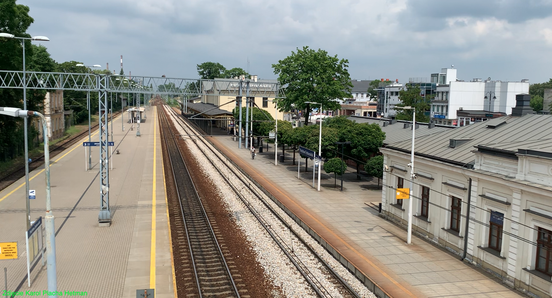
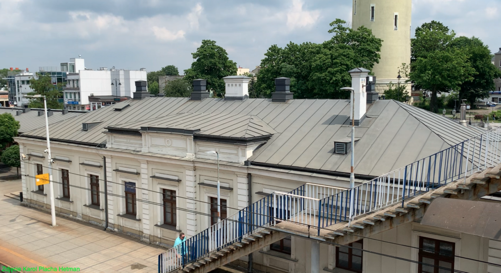
Piotrków Trybunalski Railway Station.
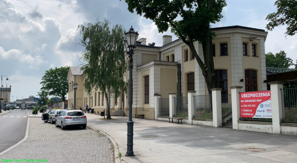
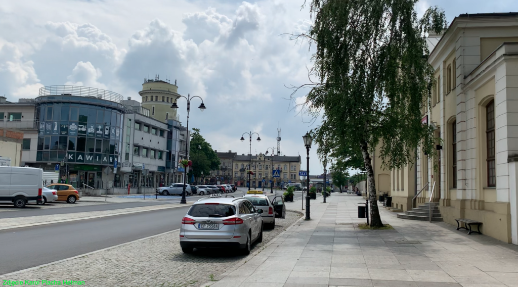
Piotrków Trybunalski Railway Station was built west of the city center, 1.2 km from the Market Square. A railway station was built on the eastern side of the tracks, and technical facilities on the western side. A locomotive depot, workshop facilities, warehouses, administrative buildings, a forwarding building, and coal and timber entanglements were constructed. A little later, the depot was expanded to a fan-shaped layout. Currently (2023), the turntable no longer exists. There was also a water tower at the corner of the workshop building, and this building is preserved. A post office building and a cargo loading ramp were also constructed. Most of these structures are listed as historic monuments.
Many buildings at Piotrków Trybunalski station have been and are currently being leased. This includes the building between the station and Juliusza Słowackiego Street, located at Platform 1, which is built in the style of a manor house. The building is listed in the register of historic monuments. It has 220 square meters of usable space. The last renovation was completed in 2012. The property is equipped with electrical, water, and sewage systems (its own sanitary facility). The building is heated by a gas furnace.
During the Great War, the station was destroyed. Virtually only the walls remained. In September 1939, the station was destroyed again. The reconstruction of the station building was completed within 50 years. Between 2010 and 2012, the station underwent its final major renovation. The official opening of the renovated station took place on July 19, 2012. The station has retained its original function, with ticket offices, a waiting room, a railway information center, restrooms, and service outlets. The square in front of the station was very large and provided space for numerous carriages, coaches, and carts. Today, it houses a transfer center, a railway station, a bus station, a taxi service, and numerous shops and service outlets.
The buildings on the western side of the tracks were transferred long ago, in the 1990s, to various companies unrelated to the railway. They are overseen by the provincial conservator of monuments. Next to the locomotive shed is a former workshop building, which has a water tower in the southwest corner. The entire site still belongs to PKP PLK.
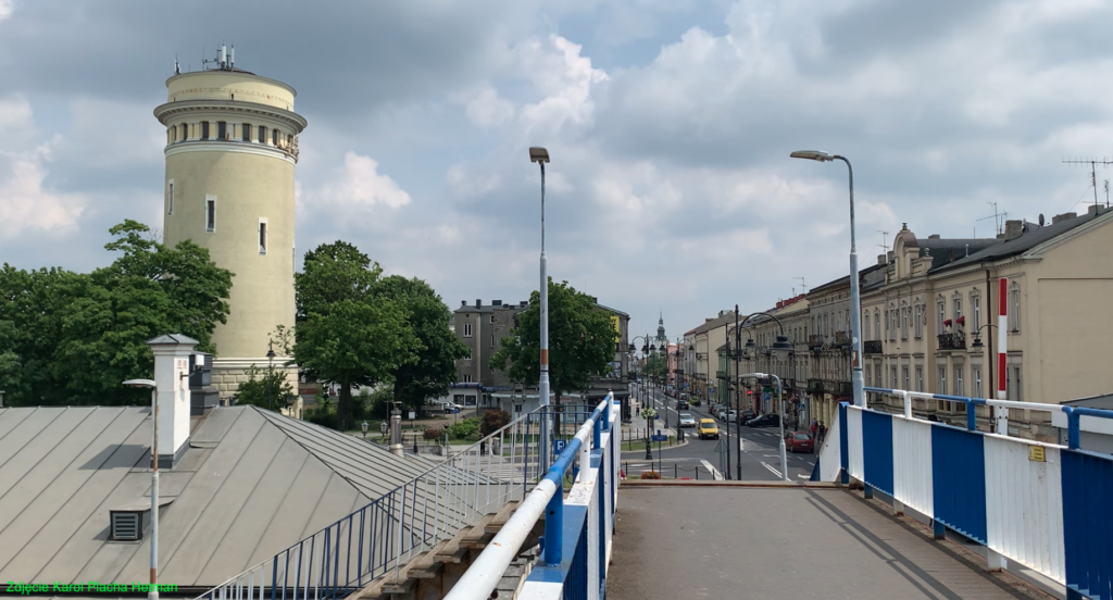
The water tower at the railway station was built between 1925 and 1927, during the Second Polish Republic. The structure stands approximately 50 meters high and is a monument to Polish engineering. Piotrków Trybunalski had three water towers.
Several railway sidings led from the station to nearby factories. On the western side is a siding belonging to the PKP Energetyka plant. The southern switch head is a branch point for several sidings and a railway line towards Bełchatów.
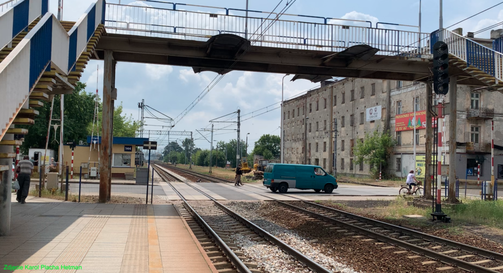
Currently (2023), the station has two platforms. Platform 1 at the station is a single-sided platform, 280 meters long, and 0.35 meters high. Access to the platform is from the station, the station square, Juliusza Słowackiego Street, and a footbridge over the tracks. Platform 2 is an island platform, 285 meters long and 0.55 meters high. Access to the platform is from a footbridge and Juliusza Słowackiego Street.
The increase in rail traffic led to the construction of a freight station southward, beyond Marszała Józefa Piłsudskiego Avenue (provincial road No. 473). A huge, fan-shaped locomotive shed with over 20 berths was built here. Currently (2023), the shed is unused. The turntable remains. Another water tower (on the northeast side of the shed), coal entanglements, numerous sidings, warehouses, and railway service buildings were constructed. The entire freight station area stretches for 1,375 meters and covers an area of 343 hectares. The area is enclosed by Czarna, Franklina Roosevelta, Wolska, Złota, and Górna Streets. Between 2013 and 2015, railway line No. 1 was modernized. The track layout was changed. The subgrade, rails with sleepers, and turnouts were replaced. One of the main-auxiliary tracks in the passenger section was removed, and the island platform 2 was widened. Both the northern and southern turnout heads were simplified. Some redundant turnouts were removed. The overhead lines were also modernized, with some poles and overhead lines replaced.
Rail traffic is controlled by the “Pt” and “Pt2” signal boxes. These use mechanical devices, centralized with traffic lights. Most of the traffic lights have been replaced and adapted to the new track layout. All main turnouts have electric drives. As part of the modernization, the “Pt1” signal box was removed.
Piotrków Trybunalski Station is currently (2023) a station of regional importance with significant passenger and freight traffic. Over the past five years (2017-2021), the station has served between 550,000 and 805,000 passengers annually. In June 2023, 69 passenger trains departed from Piotrków Trybunalski station to: Białystok, Bielsko-Biała Główna, Częstochowa, Gdynia Główna, Hel, Katowice, Koluszki, Kołobrzeg, Kraków Główny, Krynica-Zdrój, Lublin Główny, Łeba, Łódź Fabryczna, Łódź Kaliska, Olsztyn Główny, Płock, Racibórz, Radomsko, Szklarska Poręba Górna, Warsaw Wschodnia, Wrocław Główny, and Zakopane.
Railway line No. 24.
Lignite deposits were discovered in the Bełchatów region in December 1960. Natural gas exploration was underway at the time. Coal deposits were discovered in the town of Piaski. In conjunction with the construction of a lignite mine and power plant, railway line No. 24 was built, running from Piotrków Trybunalski to Bełchatów. The line was completed in 1977. The first design for the line was developed in 1973, and it was to run from Piotrków Trybunalski through Bełchatów and Zarzecze to Osiny station. Electrification of the line was planned. Longer-term plans called for line No. 24 to become a section of the Lublin-Wrocław main line (Opoczno-Oleśnica section). In 1977, the route of line No. 24 was adjusted and moved further north, from Piotrków Trybunalski-Bełchatów-Biały Ług. The line was finally opened to traffic on November 10, 1977. Some of the railway sidings are owned by PGE Górnictwo i Energetyka Konwencjonalna and are not under the control of PKP PLK.
Current line No. 24: Begins at Piotrków Trybunalski station. A branch switch is at km 2.178. The Wola Krzysztoporska passenger stop is at km 11.650. The Bogdanów passenger stop is at km 16.600. The Bełchatów station is at km 24.350. The Miasto Bełchatów passenger stop is at km 26.600. Zarzecze is a point on the line of another owner, PGE Górnictwo i Energetyka Konwencjonalna.
Piotrków Trybunalski – narrow-gauge railway.
From 1902 to 2008, the Piotrków Trybunalski Narrow-Gauge Railway operated. The line began in Piotrków Trybunalski and ran to Sulejów. Today, only the narrow-gauge railway station remains.
Written by Karol Placha Hetman