Warszawa 2025-08-21
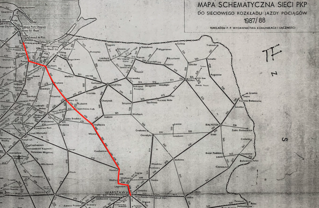
Railway line No. 9 Warsaw East – Gdańsk Główny.
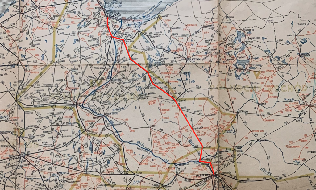
Railway line No. 9 Warsaw East – Gdańsk Główny is the second railway line in Poland, after the CMK line, on which passenger trains can run at 200 km/h. This is thanks to the modernization of this route carried out over the past few years. This line is crucial for rail traffic not only on the Warsaw-Gdańsk-Gdynia section, but also for the connection to Słupsk-Koszalin-Kołobrzeg. In January 2020, tests were conducted towards Tricity at 200 km/h, including runs by an ED250 “Pendolino” EMU train. The tests were conducted under the supervision of ETCS Level 2. However, it should be noted that from 2024, classic railcar trains with EU200 locomotives will also be able to travel at 200 km/h. The formal introduction of 200 km/h speeds on LK No. 9 took place on December 13, 2020. This approval covered several sections totaling 113 km. On the remaining sections, speeds of 170-190 km/h were permitted. The railway infrastructure was adapted to 200 km/h in 2015. At that time, the tracks were modernized and the ETCS Level 2 system was installed. All work was completed, and certificates were issued by 2021.
Railway Line No. 9 is a double-track line, electrified at 3 kV DC, and has a length of 323.393 km. The line was constructed in sections between 1852 and 1876, during a period when Poland was partitioned by Germans, Muscovites, and Austro-Hungarians. The line was constructed in the Russian Partition and the Prussian (Germanic) Partition. The line runs from central Poland northwestward and lies within the Masovian, Warmian-Masurian, and Pomeranian Voivodeships.
The opening dates for each section of the line were: Warszawa Wschodnia – Warszawa Praga, 1933, which is the last section of LK No. 9 built. Warszawa Praga – Mława, 1877. Mława – Działdowo, September 1, 1877. Działdowo – Montowo, May 1, 1877. Montowo – Iława Główna, October 12, 1876. Iława Główna – Malbork, August 1, 1876. Malbork – Tczew, October 12, 1857. Tczew – Gdańsk Południowy, August 6, 1852, which is the first section of the current LK No. 9. Gdańsk Południowy – Gdańsk Główny, October 1, 1867. On the Malbork – Tczew section, the line intersected with the Ostbahn Berlin – Królewiec line. Launch of the second track: Warsaw Praga – Mława, 1916. Mława – Malbork, 1901. Tczew – Gdańsk Główny, 1911. However, the first double-track sections were built as early as 1873. The last single-track section, Mikołajki Pomorskie – Malbork, was converted to double-track in 1967.
Electrification of the line: Warsaw Praga – Legionowo, May 27, 1972. Legionowo – Nasielsk, September 7, 1972. Nasielsk – Ciechanów, September 21, 1984. Ciechanów – Działdowo, September 28, 1985. Działdowo – Iława Główna, December 29, 1985. Iława Główna – Malbork, June 30, 1985. Malbork – Tczew, September 30, 1983. Tczew – Pszczółki 3, June 1969. Pszczółki – Gdańsk Główny, July 20, 1969.
The History of Railway Line No. 9 Warsaw – Gdańsk.
Initially, the Malbork – Mława railway line, known as the Malbork-Mława line, was a secondary line, primarily due to the attitude of the Muscovites, who were not in favor of railway development, and especially of connecting the two railways. The Prussians used this line primarily to transport grain and other agricultural produce, as well as timber, from Podolia, Volhynia, and Ukraine to the port of Gdańsk. The line was intended to connect with the Vistula Railway in the future. Merchants and industrialists from Gdańsk lobbied for the construction of the railway. This route was the shortest connection between Gdańsk and Warsaw. When the Prussian and Moscow railways were connected, the different track gauges were a significant drawback. This necessitated costly reloading at the border stations in Mława and Iława. Replacing the wheelsets of the Breidsprecha system did not solve the problem. At the stations, tracks were used at higher and lower levels. It was easier to transfer bags and crates from the wagons above to the wagons below.
It should also be noted that since 1862, a Gdańsk-Bydgoszcz-Warsaw connection had already been in place, but it was much longer and unsatisfactory for Gdańsk merchants. In 1872, a committee was established to build a line through Malbork, Iława, and Mława. The company was named the Malbork-Mława Railway, or the Germanic Marienburg Railway, Mlawaer Eisenbahn. On June 1, 1872, the Prussian government granted a concession for the construction and operation of the line. The route approved was: Malbork-Prabuty-Iława-Działdowo-Mława. At that time, Mława was in the Muscovite Partition, in the Kingdom of Poland, which was completely dependent on Moscow. The company had accumulated capital of 25.7 million marks. This amount allowed the line to be operational by the end of 1877. The lines were put into operation in stages. In May 1876, the Malbork-Iława section was opened. On October 21, 1876, the Iława-Montowo section was opened. On May 15, 1877, the Montowo-Działdowo section was opened. On November 1, 1877, the Działdowo-Mława section was opened. This marked the beginning of cross-border trade. Freight and passenger trains ran. Prussia was primarily supplied with agricultural raw materials: grain, bran, flour, potatoes, butter, eggs, cattle, ducks, geese, and construction timber. Exports included machinery (including locomobiles), agricultural tools, steel products, haberdashery, seeds, fertilizers, and more.
The construction of the Malbork-Mława Railway was regulated by the Prussian Act of November 3, 1838, on railway companies. Therefore, private capital was involved in the construction, and the state was to purchase the railway after 30 years of operation. However, the state purchased the lines earlier, on May 18, 1903. At that time, the line was placed under the management of the Gdańsk Railway; KPEV (Royal Prussian State Railways).
After the end of the Great War, under the Treaty of Versailles, Poland was granted Działdowo and a section of the line up to Rakowice station (the border station). The Smolniki station already belonged to the Germans. The Działdowo Land was granted to Poland without a plebiscite. This situation hampered the transport of goods from Warsaw to Gdańsk, even though the treaty provided for free trade. It is worth mentioning that a plebiscite was held in Iława, and 95% of the residents voted in favor of Germanic affiliation. In this situation, trains from Warsaw to Działdowo were diverted to the Brodnica – Jabłonowo Pomorskie – Grudziądz – Laskowice Pomorskie route and northward. The remaining section of the line, Iława – Prabuty – Malbork – Tczew, was a regional one. As you can easily deduce, this situation persisted until September 1, 1939, when the Germans invaded Poland. All broad gauge railways in Poland, already after the Great War, were systematically converted to standard gauge 1435 mm. A 20-year period was too short for the Działdowo – Brodnica – Jabłonowo Pomorskie – Grudziądz – Laskowice Pomorskie route to become significant for the development of the region, especially since it ran through former Prussian territory.
After World War II, the entire railway network was severely damaged and looted, with enormous losses among railway workers. Regular train service on the Warsaw-Gdańsk line was resumed only on January 16, 1946, a year after the Soviet army’s invasion. Initially, service operated on only one track. The second track was partially missing or devastated. Service on the second track was resumed in mid-1947.
Since 1952, reinforced concrete St3 sleepers had been manufactured in Poland. These proved to be less successful, and in 1958, the first INBK-3 and INBK-4 sleepers were developed, followed by INBK-8 sleepers in 1972. Initially, S49 type rails were laid on the Warsaw-Gdańsk line, and from the mid-1970s, S60 type rails were installed. However, the work was carried out in sections. A general improvement on LK No. 9 took place between 1983 and 1985, when the entire track was replaced with new ones, which was necessary to prepare for electrification. At the same time, there were plans to standardize the holding tracks for freight trains. During this period, the length of freight trains with steam locomotives, with dual traction, could be assumed to be 800 m, 650 m, and 550 m, respectively. This translated into trains with 150 axles, 120 axles, and 100 axles, respectively, taking into account the capacity of dual traction. Another challenge was the need to lower the tracks under viaducts to accommodate the train gauge and electric traction.
Regarding electrification, the Warsaw to Nasielsk junction was electrified in 1969, and the Gdańsk to Tczew junction in 1972. The remaining electrification of Line No. 9 began in 1984. To expedite the process, work was carried out from both the Nasielsk and Tczew sides. The two companies electrifying the line met at Rybno Pomorskie station. This was the first time this construction method had been used. Subsequent new lines were electrified using this method. The ceremonial launch of electric traction on the entire Warsaw-Gdańsk route took place on December 19, 1985. The ribbon was cut by then-Minister of Communication, Janusz Kamiński, at Działdowo station. The first passenger train, with locomotive EU07-213, from the Warsaw Odolany depot, ran on December 19, 1985. The line was adapted to a speed of 120 km/h.
Currently (2025), this work is criticized because it squandered the opportunity to modernize LK No. 9 for speeds above 120 km/h. The problem is that standard Polish EU07 locomotives were only capable of 125 km/h, so planning the route for 160 km/h at that time made no sense. Erecting traction poles fixed the geometry of the route, which, contrary to appearances, is not an easy task. Despite all this, there was a significant reduction in travel time, energy savings, an increase in line capacity and a reduction in the number of train breakdowns on the route.
In the 1990s, a feasibility study was conducted to modernize the Warsaw-Gdańsk line No. 9. This modernization was intended to improve traffic along the entire route. Due to the difficulty and enormous cost associated with rebuilding virtually the entire Warsaw-Gdańsk section, the use of foreign rolling stock with tilting bodies was proposed. Tests of such rolling stock were conducted in May 1994, using the ETR-460 “Pendolino” EMU train set with inertial or controlled tilt, manufactured by the Italian company Fiat Ferroviaria. The tilting bodies will enable the train to travel around curves at speeds up to 30% faster than conventional rolling stock. The tilt of the ETR-460 “Pendolino” EMU train can be up to 7%. The tilting body can withstand lateral accelerations of up to 1.8 m/s². A standard body can withstand lateral accelerations of up to 0.6 m/s². Tests were conducted on a 25 km section between Rybno Pomorskie and Rakowice stations. This section featured curves with radii ranging from 470 m to 1,500 m. The tests confirmed the feasibility of using this type of rolling stock on the Polish State Railways (PKP). Thanks to its use, line speeds could be increased to over 200 km/h without significant track modernization costs. The then PKP management even announced a tender for the purchase of this type of rolling stock, but due to a lack of funding, the tender was not completed.
Until 2006, the maximum train speed was 120 km/h. The largest modernization of Line No. 9 took place between 2006 and 2014. At that time, the line was adapted to speeds of up to 200 km/h for passenger trains with the ETOS system, 160 km/h without the ETOS system, and 120 km/h for freight trains, with an axle load of 22,500 kg. The modernization cost PLN 10 billion. On August 14, 2025, the fastest train covered the Warsaw Wschodnia – Gdańsk Główny route in 2 hours 18 minutes; the EIP Pendolino. Ticket price PLN 169.00. A classic train with wagons covers the route in 2 hours 34 minutes: the EIC with an EU200 locomotive. Ticket price PLN 149.00. A Koleje Mazowieckie train covers this route in 3 hours 15 minutes. Ticket price PLN 60. All connections are direct.
The modernization was carried out in stages. The project was developed in 2004. It included the construction of LCSs in Działdowo, Iława, Malbork, Gdańsk, Gdynia, Ciechanów, and Nasielsk. Interestingly, in 2004, it was anticipated that trains capable of speeds of 200 km/h would have tilting bodies. At that time, negotiations were underway to purchase Pendolino trains with tilting bodies. After thorough analysis, it was determined that without the tilting bodies, the trains would also travel at 200 km/h. The design included profiling of railway curves.
A significant safety issue was the elimination of rail-road crossings. These were removed and replaced with viaducts over the tracks or tunnels under them. The lack of grade-separated crossings on Line No. 9 was met with protests from residents demanding grade-separated crossings in the Gdańsk districts of Orunia – Święty Wojciech – Lipce.
However, so-called protective ribs have been installed on the tracks leading to the line, preventing trains from accidentally entering occupied tracks. Separation signals and an Automatic Line Blocking System were also introduced for safety reasons.
Concrete talk of modernizing the line began in the summer of 2012. Promises from individual political parties intensified, especially before the 2015 parliamentary elections. The then government announced it would guarantee PLN 2.2 billion for railway investments on the Warsaw – Gdynia line and beyond towards Kołobrzeg. Major work began in 2014. An agreement to co-finance the modernization of the Warsaw – Gdynia railway line, a 103-kilometer section running through Iława and Malbork, was signed. The initial funding amount for this investment was PLN 1.4 billion. At the time, it was the largest railway investment in Poland. Ultimately, the investment cost reached PLN 3 billion. PLN 1.8 billion was secured from EU funds. Final costs: Total cost of project one: PLN 2,027,544,054.59. EU funding: PLN 1,220,561,930.19. Total cost of project two: Total cost of project two: PLN 1,131,414,678.07. EU funding: PLN 620,629,656.28.
The work included the replacement of over 200 km of track, the reconstruction, renovation, and construction of over 280 engineering structures, including 6 railway bridges, 3 road bridges, 25 railway viaducts, 18 road viaducts, 220 wildlife deterrent devices, and 8 pedestrian crossings under the tracks. The project also involved the removal of 68 level crossings and pedestrian crossings. The entire railway line was equipped with computerized rail traffic control, further improving rail safety. Crossings for migratory animals crossing the railway tracks were also installed along the line. Noise barriers were installed in localities.
Railway Line No. 9 is part of the E65 line, part of the VI Pan-European Transport Corridor, connecting the Baltic Sea regions with the Adriatic Sea and the Balkans. Line E 65, which runs through the following stations: Gdynia, Warszawa, Katowice, Most Wisła, and Zebrzydowice, is over 720 km long. The entire line is fully electrified.
LK No. 9 route Warsaw East – Gdańsk Główny.
Warsaw East station (0 km, elevation 90 m). Lines No. 2, 7, 45, 448, 452, and 902 are located here. After the station, the line turns north. It passes the intersection of Boruta Street and crosses a viaduct over Kijowska Street. Lines No. 502 and 545 join from the eastern side.
Michałów junction (7.09 km, elevation 85 m). Lines No. 502 and 545 are located here. The line then proceeds upwards, over truss bridges, past Solidarności Avenue and the Warszawa Wileńska railway line.
Warszawa Targówek passenger stop (km 7.43, elevation 86 m). There are two single-track platforms here.
Targówek station (km 8.40, elevation 88 m). There are single-track lines No. 501 and 504 here, which branch off from line No. 9 to the west and east. Then, from Warszawa Gdańska station, line No. 20 joins from the west. The east-west bypass track runs over a truss bridge.
Warsaw Praga station (km 10.10, elevation 84 m). There is line No. 20 here. Warszawa Praga is a large freight station and a passenger stop with an island platform. To the west is the former FSO Żerań factory, and further on, the Vistula River. Line No. 9 has a maximum speed of 160 km/h.
Warsaw Toruńska passenger stop (km 12.00, elevation 84 m). There is one island platform here. The S8 motorway runs above the stop. Industrial areas and numerous workplaces are located here.
Warsaw Praga R77 interchange (12.78 km, elevation 85 m). On the western side is the former river port on the Żerań Canal. The line then crosses the Żerań Canal via a truss bridge and over DW No. 633, Płochocińska Street.
Warsaw Żerań passenger stop (14.53 km, elevation 85 m). There is one island platform here.
Warsaw Praga R95 interchange (16.22 km, elevation 83 m). Line No. 456, which accompanies Line No. 9, terminates here. This is where the Warszawa Praga freight station ends, providing grade-separated access to and from Line No. 9. Czołowa Street runs on the eastern side.
Warszawa Płudy passenger stop (16.98 km, elevation 83 m). From this stop, the maximum speed is 200 km/h. There are two single-edge platforms here. There are three tracks. Klasyków Street runs above the stop. Then Marcelego Jeżewskiego Street runs above it.
Warsaw Choszczówka passenger stop (km 19.72, elevation 82 m). There are two single-edge platforms here. The line enters the Legionowo Forest and the Warsaw city limits. An electronic wildlife deterrent system is installed on the line. The line gradually heads westward, entering the city of Legionowo. Polna Street passes under the tracks. The tunnel opened in 2024.
Legionowo station (km 25.11, elevation 82 m). Line No. 10 is located here. The viaduct of national road No. 61, Zegrzyńska Street, passes over the top of the platforms. The station has two double-edge platforms. There is a transfer center here. Line No. 10 branches from the station, providing grade-separated connections to Zegrze and Tłuszcz stations. Ludwisin station (km 26.40, elevation 80 m). Line No. 511 (switching point) is located here. Line No. 9 is already running westward. Along Parkowa Street, there’s a footbridge over the tracks for pedestrians and cyclists. The line once again has three tracks, with noise barriers on the sides.
Legionowo Stop: Passenger stop (km 27.47, elevation 80 m). There are two single-edge platforms here. Noise barriers are present throughout. The Partyzantów/Father Augustyn Kordeckiego Street viaduct runs overhead.
Chotomów Stop and Switch (km 29.40, elevation 80 m). There are two single-edge platforms here. This is the terminus of accompanying line No. 456. The barriers end, and the line enters the Chotomowskie Forest. Leaving the forest, the line enters agricultural land. Former military forts are nearby.
Janówek Stop: Passenger stop (km 36.75, elevation 80 m). There are two single-edge platforms, arranged in a passing loop. Warszawska/Dworcowa Street runs between the platforms. Industrial areas are also located here.
Nowy Dwór Mazowiecki station (km 39.95, elevation 77 m). There are two single-edge platforms and sidings to industrial plants. A viaduct with Ignacego Paderewskiego Street passes above the platforms. Next is the intersection with Jana Nałęcza Street. The line then curves north to cross the Narew River. Before the river, the line passes under national road no. 85. On the western side of the line is the Military Training Base and the former Marina Modlin port.
The Feliks Pancer Bridge over the Narew River is a combined rail and road bridge. The roadway for vehicles is located above Track No. 1. The bridge is located along Thommée Street. The combined rail and road bridge over the Narew River was built in 1877, designed by engineer Kazimierz Zieliński, as part of the construction of the Vistula Railway. It was destroyed during the Great War and rebuilt afterward, but with a truss structure. Vehicular traffic on the bridge operated as an alternating system. During World War II, the bridge was also blown up and rebuilt by the Germans in 1942. At that time, wider piers were constructed and a western carriageway was added. This created a bridge with two tracks. The alternating traffic was eliminated. In 1945, the bridge was blown up again and soon rebuilt. In 1973, the bridge was rebuilt again, using elements from the bridges in Malbork and Tczew. In 2009, during the modernization of railway line No. 9, the bridge was rebuilt. The western lane was rebuilt. The eastern lane, with the track below and the road above, was renovated. Currently, these are two different bridges, supported by the same piers. The bridge for track No. 2 is welded and has longer spans. Train speeds up to 100 km/h (62 mph). The eastern bridge, for track No. 1, is riveted and has shorter spans. The abutments are reinforced concrete. Train speeds up to 90 km/h (56 mph).
Modlin station (44.10 km, elevation 80 m). Before the station is an intersection with Mieszka I Street. The station has two platforms and three platform edges. There is a footbridge over the tracks. There is a siding to the fuel station at Modlin Airport. The line runs northeast. Further on, there’s another intersection with Mieszka I Street. On the eastern side are the marshy areas of the Narew River. Further on, there’s an intersection with Kościelna Street. The line crosses the Wkra River on a truss bridge.
Pomiechówek passenger stop (km 48.55, elevation 80 m). There are two single-edge platforms here. Beyond the platforms is an intersection with the national road no. 62 Modlińska/Serocka. The line heads north. Further on, there’s an intersection with Nasielska Street, and the line enters forests with old forts. A wild animal deterrent system is in place. Pieńki was a block guard post (km 51.33, elevation 95 m). The building, which is now used as a residence, has survived.
Brody Warszawskie passenger stop (km 53.19, elevation 104 m). There are two single-edge platforms here, arranged as a passing loop. There is a passage under the tracks. The line enters agricultural land.
Studzianki Nowe passenger stop (km 55.91, elevation 106 m). There are two single-edge platforms here, arranged as a passing loop. A local road runs overhead between the platforms.
Nasielsk station (km 60.15, elevation 107 m). There are two platforms and four platform edges here. There is a passenger tunnel. Lines No. 27 and 1013 (narrow gauge) are located here. There was also a Nasielsk-Legionowo line, which was dismantled. There is a LCS here. Narrow gauge line No. 1013 Nasielsk-Pułtusk was launched in 1950 and closed in 2011. Before Nasielsk station, there’s an intersection on Srebrna Street. The line then crosses the Nasielna River and passes under DW No. 571, Kolejowa Street. Further along the line, there’s an intersection with a local road in the town of Kosewo. Further along the line, there’s a wildlife deterrent system.
Kątne passenger stop (km 63.95, elevation 114 m). There are two single-edge platforms arranged in a passing loop. DW No. 632 passes overhead between the platforms. Further on, a local road runs through a tunnel under the tracks. This area is agricultural land.
Jackowo Dworskie passenger stop (km 66.82, elevation 132 m). There are two single-edge platforms arranged in a passing loop. A local road passes overhead between the platforms. Further on, local roads pass overhead twice.
Świercze passenger stop and passing loop (km 71.44, elevation 155 m). This was formerly a station. There are two single-edge platforms, arranged in a passing loop. There is a passenger tunnel. Between the platforms is the DW No. 620 intersection at Pułtuska Street. Further on, a local road passes under the tracks.
Kałęczyn passenger stop (75.72 km, elevation 135 m). There are two single-edge platforms, arranged in a passing loop. There is a passenger tunnel. Further on, there is a viaduct over the tracks with a local road. Then, the local road passes under the tracks. The line runs through a forest.
Gąsocin station (km 79.66, elevation 117 m). A local road, Pułtuska Street, passes under the tracks. There are two platforms and three platform edges, as well as a passenger tunnel. There is also a two-story wooden station, which requires renovation. Behind the station, the local Graniczna Street passes under the tracks. Further on, Ciechanowska Street passes over the tracks. Then, two more local roads pass under the tracks.
Gołotczyzna passenger stop (km 85.38, elevation 104 m). Before the stop, the line crosses the Sona River. There are two single-edge platforms here, arranged in a passing loop. Kolonia Street passes under the platforms. The line then passes local roads three times without any collision. Krubin is a blocking station (km 91.39, elevation 119 m). A pedestrian bridge over the tracks is already in Ciechanów. Further on, the line passes under national road no. 50. The line then crosses the Łydynia River.
Ciechanów Industrial Passenger Stop (km 95.30, elevation 114 m). There are two single-edge platforms here, arranged in a passing loop. National road no. 60 runs on a viaduct between the platforms. At the stop, there is also a siding to industrial plants, which begins at Ciechanów station. The line then passes under Płocka Street.
Ciechanów Station (km 98.06, elevation 124 m). There is a local railway control point (LCS) here. A narrow-gauge railway line, lines 1016 and 1017, operated here from 1920 to 1981. In front of the station, there is a footbridge over the tracks for pedestrians and cyclists. A little further on, there is a road under the tracks, Spółdzielcza Street. The station has two platforms, four sidings, a passenger tunnel, and numerous sidings. After the station, the line passes under Gąsecka Street. Further on, there are three grade-separated intersections with local roads and DW No. 615. Pawłowo used to have a passing loop (km 104, elevation 125 m).
Czeruchy passenger stop (km 106.32, elevation 127 m). There are two single-edge platforms here, arranged in a passing loop. A local road runs between the platforms, above. Further on, there is a grade-separated intersection with a local road. There are agricultural lands and small forests here.
Krośnice Mazowieckie passenger stop (km 110.02, elevation 126 m). There are two single-edge platforms here, facing each other. A local road runs below the platforms. The line then passes under DW No. 615.
Konopki station (km 113.85, elevation 129 m). In front of the station, a local road, Handlowa Street, runs overhead. The station has two platforms, three platform edges, and a tunnel under the tracks. The station serves as a passing loop. The line then passes through farmland.
Stupsk Mazowiecki passenger stop (km 117.15, elevation 133 m). There are two single-edge platforms, arranged in a passing loop, and a tunnel under the tracks. A local road, Henryka Sinkiewicza Street, the Stupsk bypass, passes overhead behind the platforms. The line then passes under a local road.
Wyszyny passenger stop (km 122.39, elevation 159 m). There are two single-edge platforms, arranged in a passing loop, and a local road passes overhead between the platforms. The line then passes under the S7 motorway, then under a local road, and then under national road no. 587. The line enters the city of Mława.
Mława Miasto passenger stop (km 127.75, elevation 143 m). There are two single-edge platforms, arranged opposite each other. The platforms are long. Szreński Viaduct Street passes over the platforms. This is the main passenger stop in Mława, and long-distance trains stop here.
Mława station (km 130.38, elevation 143 m). Narrow-gauge railway No. 1018 is located here. The station has two platforms and three platform edges. There is a tunnel for passengers. However, only regional trains stop here. Rypiński Viaduct Street passes above the platforms. Further on, in the northern part of the city, the line passes under Mazurski Viaduct Street. On the western side of the line runs Voivodeship Road No. 544. The border between the Masovian Voivodeship and the Warmian-Masurian Voivodeship (km 130.38).
Iłowo station (km 136.46, elevation 158 m). Iłowo is a large freight station. Behind the freight station is a passenger stop with two single-edge platforms facing each other. Wyzwolenia Street passes above the platforms Voivodeship Road No. 544. There’s a station, a water tower, a historic signal box, and a Ty45-205 steam locomotive and a 32D47-221 tender on a side track. The locomotive is owned by the Iłowo-Osada commune. The line then passes under a local road and the next road, Kraszewska Street. In Narzym, along Kościelna Street, there’s a pedestrian and cyclist tunnel.
Narzym passenger stop (km 140.31, elevation 156 m). There are two platforms here, single-edged, arranged in a passing loop. Between the platforms, a local road, Dworcowa/Kolonia Street, passes under the line. The line then runs through cultivated fields. At km 142, there was a sectional checkpoint. A guardhouse remains. At km 143, there was a guarded level crossing. Currently, there is a road under the tracks. A guardhouse remains. At km 144, a local road passes under the tracks. Previously, there was a guarded level crossing. At km 146, there is another road under the tracks. Before Działdowo, the line crosses the Torfiaki Działdowskie River. The bridge is steel, welded, with arches.
Działdowo station (km 148.22, elevation 163 m). Lines No. 208 (Lidzbark) and No. 216 (Nidzica) are located here. Before the station, the line runs on an embankment and passes Jana Kochanowskiego and Księżodworska Streets, and before the station, the line passes under DW No. 544, Lidzbarska Street. Działdowo is a junction station, located on the northern side of the city. The station features a double water tower, three platforms and five platform edges, a large station building, a local control center, and railway workshops. Leaving the station, the line passes under Line No. 216 (Nidzica) at the bottom. At km 152, there was a rail-road intersection, which has since been removed. A guardhouse remains.
Burkat passenger stop (km 153.12, elevation 163 m). There are two single-edge platforms opposite each other. A local road runs below the platforms. Beyond are forests and fields. At km 155, there is an automatic control level crossing. At km 157, it crosses over a local road at the top.
Turza Wielka station (km 157.94, elevation 177 m). Line No. 256A is located here. This is the highest point of line No. 9. There are two single-edge platforms opposite each other. The line then turns west and enters the forest. A wildlife deterrent system is located here.
Gralewo station (km 162.03, elevation 163 m). In front of the station, a local road runs beneath it. There are two platforms and three platform edges. After the station, the line turns northwest again. On the northeast side, runs DW No. 538.
Żabiny passenger stop (km 166.49, elevation 163 m). There are two single-edge platforms here, arranged in a passing loop. Between the platforms is a trimmed rail-road crossing. Further on are agricultural fields. Speeds on the line are up to 150 km/h.
Tuczki passenger stop (km 168.76, elevation 162 m). There are two single-edge platforms here, arranged opposite each other. Behind the platforms, a local road runs beneath. The line then crosses the Wel River. The line enters forests and lakes. The line is still accompanied by DW No. 538. At km 169 and 171, there are automatically controlled road crossings.
Rybno Pomorskie station (km 173.05, elevation 155 m). Before the station, there is an automatically controlled road crossing. There are two platforms, three platform edges, and a tunnel under the tracks. The station serves as a passing loop. The line then winds through fields, forests, and lakes. At km 174, there is an automatic road crossing.
Jeglia passenger stop (km 175.91, elevation 166 m). There are two single-edge platforms arranged in a passing loop. A local road runs between the platforms.
Hartowiec passenger stop (km 178.51, elevation 164 m). There are two single-edge platforms arranged in a passing loop. A footbridge for pedestrians and cyclists runs between the platforms. The historic railway buildings have been preserved. Beyond the platforms, the line passes under DW No. 538, and the road will now be on the western side of the line. Further on, the line passes under DW No. 541. At km 181 and 183, there are automatic road crossings.
Montowo passenger stop, former station (km 183.72, elevation 142 m). There are two single-edge platforms here. There’s a station building, a rectangular water tower, a warehouse building, a restroom building, and a tunnel under the tracks. The line then runs through farmland. At km 186 and 188, the line passes under local roads.
Zajączkowo Lubawskie is a junction station (km 189.50, elevation 122 m). Lines 252 (Lubawa) and 260A (Nowe Miasto Lubawskie, decommissioned) are located here. There are two single-edge platforms here. The railway buildings have been preserved. There are noise barriers in front of the platforms. Further up, the line crosses four local roads.
Rakowice station (km 195.80, elevation 105 m). There are two platforms, three platform edges, a tunnel under the tracks, and numerous railway buildings. After the station, the line passes under national road no. 15 and runs through forests. A wildlife deterrent system is installed here. The line crosses the Drwęca River, the former Polish-Germanic border; 199.00 km.
Smolniki passenger stop (km 203.22, elevation 110 m). There are two single-track platforms and a tunnel under the tracks. Smolniki is primarily one of the forest districts of the Iława Forest District. Smolniki is inhabited primarily by Forest District employees. There is a timber logging and processing plant here. While still in the forest, the line reaches the town and the Iława Główna station. Line No. 9 splits into two double-track routes. Freight train tracks branch off to the right, and passenger train tracks branch off to the left. The line passes under Wojska Polskiego Street, then the line from Toruń station.
Iława Główna junction and LCS station (km 208.97, elevation 110 m). There are three platforms and six platform edges. The station houses a historic station dating from 1905, with historic platform shelters and a post office building. Beyond the platforms, the railway lines pass under Lubawska Street and split towards Olsztyn (northeast) and Gdańsk (northwest). Further on, there is a guarded intersection at Kardynała Stefana Wyszyńskiego Street. The line then crosses Jana III Sobieskiego Street. Soundproofing is provided.
Iława Miasto passenger stop (km 211.84, elevation 108 m). There are two single-edge platforms here. Biskupska Street passes above the platforms. Further on, the line crosses National Road No. 16 (km 212) at a guarded intersection. Again, there are forests and fields. A wildlife deterrent system is in place. Forest roads cross the tracks twice. At km 216, a local road crosses the line. At km 218, the former Segnowy station is located. There are railway buildings used as apartments.
Ząbrowo passenger stop (km 219.23, elevation 100 m). There are two single-edge platforms arranged in a passing loop. The platforms are connected by a tunnel. A local road, Lipowa Street, passes above the platforms, as well as the Osa River. Further on are fields. The line passes under local roads: Malinowa Street (km 221, with a preserved guardhouse), Leśna Street, and Falkowa Małe Street.
Redaki station (km 225.11, elevation 106 m). There are two platforms, three edge platforms, and a tunnel under the tracks. There is a station. There is a siding to the Dragongaz company. Further on, the line passes under a local road. There are fields and forests. There is a wildlife deterrent system. The line passes over a local road, and then there is a guarded intersection.
Susz station (km 232.42, elevation 105 m). Before the station, the line passes under Piastowska Street. There are two single-edge platforms, arranged in a passing loop, and a tunnel for passengers. A siding leads from the station to the INCO company. There is a “Su” signal box and a station. The station is built of dark red brick. It is two-story and has an attic. The line then crosses Kardynała Stefana Wyszyńskiego Street at an elevated level and re-enters the forest. A wild animal deterrent system is in place. The Warmian-Masurian/Pomeranian Voivodeship border is 236.95 km away, located on the Liwa River. Stankowo is a former passenger stop (km 237.59, elevation 95 m).
Prabuty station (km 242.29, elevation 99 m). Lines include: No. 218 Prabuty – Kwidzyń, No. 232 Prabuty – Myślice. Line No. 232 operated from 1899 to 2006. Currently completely dismantled. Before Prabuty station, Voivodeship Road No. 521, Rypińska/Władysława Jagiełły Street, crosses the tracks. The viaduct is a truss structure. The station features two platforms, four rails, a tunnel under the tracks, a station, a granary, and a water tower. After the station, the line crosses Voivodeship Road No. 520, Parkowa Street. The line then runs along Voivodeship Road No. 522. The line crosses the Liwa River and passes under Voivodeship Road No. 522. This area is arable land.
Gdakowo passenger stop (km 249.40, elevation 90 m). Before the platforms, the line crosses under a local road. There are two single-rail platforms, opposite each other. There are railway buildings.
Mikołajki Pomorskie passenger stop (km 253.56, elevation 81 m). Before the platforms, the line crosses a local road. There are two single-edge platforms opposite each other. Sound-absorbing screens are installed on the city side. There are agricultural lands here. Next, the line passes through the local road no. 522, the village of Kołoząb. The line then passes two local roads without any grade separation.
Mleczewo station (km 262.46, elevation 45 m). There are two single-edge platforms here. After the platforms, the line passes under the local road no. 517. Next is a freight station, serving as a passing loop. Then, the line passes under a local road. Then, there is the Młynówka Malborska River. Next, the line passes under a local road, then over a local road.
Dąbrówka Malborska passenger stop (km 268.98, elevation 42 m). Formerly, at km 267, there was a cargo hold. The station buildings remain. The stop has two single-edge platforms, facing each other. A local road runs beneath the platforms. This area is agricultural land.
Gronajny passenger stop (km 272, elevation 39 m, elevation 34 m). There are two platforms, arranged in a passing loop. A local road runs between the platforms, above them. This is where the Malbork railway junction begins.
Malbork junction station and LCS (km 277.88, elevation 15 m). Lines 204, 207, 222, and 5009 are located here. Beyond the station, the line crosses the Młynówka Malborska River and the Nogat River.
Malbork Kałdowo passenger stop (km 279.61, elevation 12 m). There are two platforms here, opposite each other. Before the platforms, the line passes over national road no. 55. Then the line enters the Żuławy region. Ostrówek Pomorski is a former station (km 282.90, elevation 5 m).
Stogi Malborskie passenger stop (km 283.76, elevation 4 m). Formerly, the line to Nowy Dwór Gdański station, national road no. 256, branched here northward. There is one island platform here. A local road passes over the platforms.
Szymankowo station (km 286.74, elevation 4 m). Line no. 256 was here. The station has two platforms, three platform edges, and a tunnel under the tracks. A local road passes over the tracks at the western station head. Świetlikowo is a former railway station (km 291.05, elevation 4 m).
Lisewo is a passenger stop (km 293.82, elevation 15 m). Narrow-gauge railways used to operate here; Nos. 5005 and 5006. There are two single-edge platforms facing each other. Behind the platforms, a local road, Kolejowa/10 Marca Street, passes under the line. Further on, the line crosses the Vistula River. The largest railway bridge on LK No. 9 is located here. The bridge is a truss bridge for two tracks and is constructed of various spans. A road bridge, currently undergoing renovation, runs south of the railway bridge. Immediately beyond the railway bridge is the Tczew Wisła junction (km 295.22, elevation 21 m). Line No. 732 is located here.
Tczew is a junction station and LCS (km 296.24, elevation 23 m). Lines No. 131, 203, 726, 727, and 728 are located here. Tczew is a major railway junction, with lines from four directions. A large freight station is located in the northwest. Tczew boasts numerous watercourses, including the Kania Młyński River, the Motława River, and many others. National Road No. 91 runs from Tczew on the western side of the line.
Miłobądz passenger stop (km 302.79, elevation 8 m). There are two platforms and three platform edges here. A local road passes above the platforms.
Pszczółki station (km 306.64, elevation 17 m). Lines No. 233, 260, and 265 are here. Line No. 260 runs parallel to Pruszcz Gdański station. There are two platforms and four platform edges here. This was formerly a junction station on the Pszczółki – Skaryszew – Starogard Gdański line.
Skowarcz passenger stop (km 308.42, elevation 15 m). There are two single-edge platforms here, arranged in a passing loop. A local road, Żuławska Street, passes above.
Różyny passenger stop (km 311.69, elevation 14 m). There are two single-edge platforms set up as a passing loop. A local road, Łąkowa Street, passes overhead in front of the platforms. The line then passes Szkolna Street and the Kłodawa River overhead.
Cieplewo passenger stop (km 314.32, elevation 10 m). There are two single-edge platforms set up as a passing loop. Przemysłowa Street passes overhead in front of the platforms.
Pruszcz Gdański station (km 317.12, elevation 7 m). Lines No. 226, 229, 260, and 262 are located here. This line was formerly the Pruszcz Gdański – Stara Piła railway line. Several sidings branch off from the station. The station has two island platforms. On the eastern side of the station is the Pruszcz Gdański military airport. On the western side of the line flows the Radunia River. Beyond the station, the line passes under DW No. 226, Fryderyka Chopina Street, and then NSZZ Solidarność Street. The lines then intersect viaducts, allowing two tracks to reach the port of Gdańsk and two more tracks to continue on to the Tricity area. Gdańsk Święty Wojciech is a former passenger stop (km 320.88, elevation 5 m). The line passes the Radunia River and passes under the S7 motorway. The line enters the city of Gdańsk.
Gdańsk Lipce passenger stop (km 322.05, elevation 5 m). There are two platforms opposite each other. Further on, there are three pedestrian and cyclist tunnels under the tracks.
Gdańsk Orunia passenger stop (km 324.53, elevation 5 m). There are two single-edge platforms arranged in a passing loop. Plac Oruński Street runs below the platforms. A single-track line from the Gdańsk Seaport joins the line from the east. Further on, there is an intersection with Sandomierska Street.
Gdańsk Południowy freight station (km 325.884, elevation 3 m). Lines No. 9a and 721 are located here. The Pomeranian Mechanical and Track Company is located here.
Gdańsk Biskupia Górka passenger stop (km 326.30, elevation 5 m). National Road No. 91, the St. Wojciech Route, runs above. Gdańsk Śródmieście station belongs to the SKM (Fast Urban Railway), not to LK No. 9. DW No. 501 passes over the top, and the railway lines run in a tunnel. The line then passes under Hucisko Street. Gdańsk Brama Wyżynna was a station (km 327.57, elevation 5 m).
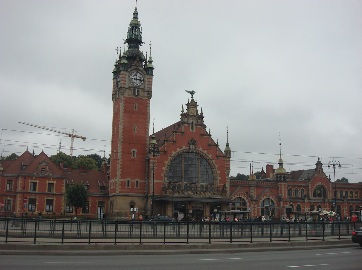
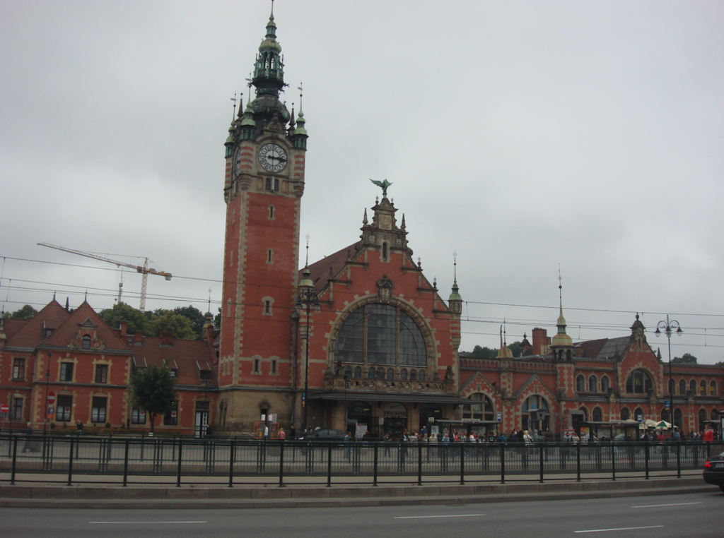
Gdańsk Główny station (km 327.74, elevation 4 m). Lines 202, 227, 249, and 250 are located here.
Written by Karol Placha Hetman