
Łuków 07-01-2026
PKP Łuków – Ivangorod Railway.
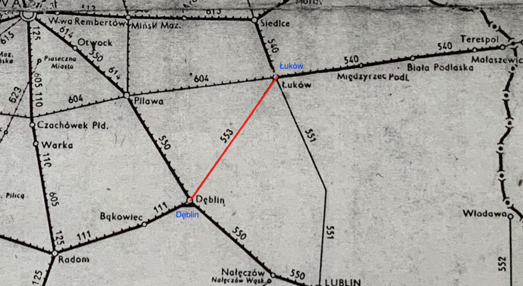
The Łuków-Ivangorod Railway was launched in 1876 as a branch of the Vistula Railway. The route was 56.78 versts long and connected the Warsaw-Terspol Railway with the Ivangorod-Dąbrowa Railway. Two railway stations were built on the route: Krzywda and Rossosz (later Leopoldów). In May 1875, J. A. Kraszewski became the chief engineer of the route. In November 1875, the line was equipped with a telegraph line. The first trains departed on September 1, 1876, following its technical acceptance on August 25, 1876. On October 22, 1876, a government commission issued a certificate of operation for the Łuków-Dęblin line. From December 2, 1876, military and local freight trains ran on the route. Long-distance passenger trains were not operated on this route. Civilians were not allowed on courier and passenger-freight trains if they were carrying military personnel. Civilians had to wait for the next train. Freight trains mainly carried firewood and construction timber to Prague and Warsaw. Transport tariffs were established. In 1885, landowners submitted an application to build a loading station on the Wola Okrzejska land, between the Krzywda and Leopoldów stations. Eventually, the Okrzeja (Okszeja) station was built. Additional stops were built at Łapiguz, Sarnów (March 1927), and Ryki. On November 9, 1891, a disaster occurred at verst 45. Unknown perpetrators spun the rails, derailing the locomotive, wrecking four wagons, and damaging another four. Fortunately, no one was injured. In March 1892, the last wagon of a train carrying hard coal caught fire on the line. The wagon was detached and the fire extinguished. The fire was likely caused by sparks from the locomotive. Forest fires near the tracks were common on this line. Sparks from steam locomotives ignited the forests. This forced the railway to introduce firebreaks. At that time, locomotive breakdowns were common on the line, requiring the dispatch of reserve locomotives. Locomotives sometimes had to be repaired on the line. There was never a head-on collision between trains on the line, despite it being a single-track line. However, on October 1, 1909, a freight train was dispatched to the line while sectional rail replacement was underway. The locomotive and two wagons were damaged. Removing the locomotive and wagons took several hours. No one was injured. Special trains carrying the Tsar, his family, and Moscow governors passed through the route several times. This route bypassed Warsaw, traveling to their residence in Spała, near Tomaszów Mazowiecki. In October 1913, the decision was made to build a second track along the route. This was part of a larger project: Kovel – Brest – Łuków – Dęblin. In 1929, brick station buildings and platform restrooms were constructed at the stations and stops along the route. In 1930, quarters for railway workers’ families were built at the stations, and residential buildings for track workers were built at the stops. On the Łuków – Dęblin route, the second track was not opened until 1931. As part of the work, bridges and culverts were widened, and rail-road crossings were rebuilt. Much of the work was performed by railway troops and bridge construction troops. Construction took five weeks and was carried out in unfavorable weather. Finishing work continued until 1932. During World War II, partisans derailed several German trains. The disruptions typically lasted 10-15 hours. Partisan losses included 10 dead, 17 seriously wounded, and 62 slightly injured. In retaliation, the Germans carried out public executions of those arrested in Dęblin and Łuków. In subsequent cases, Poles from neighboring towns fled into the forest for several days.
Route of LK No. 26 Łuków – Dęblin – Radom:
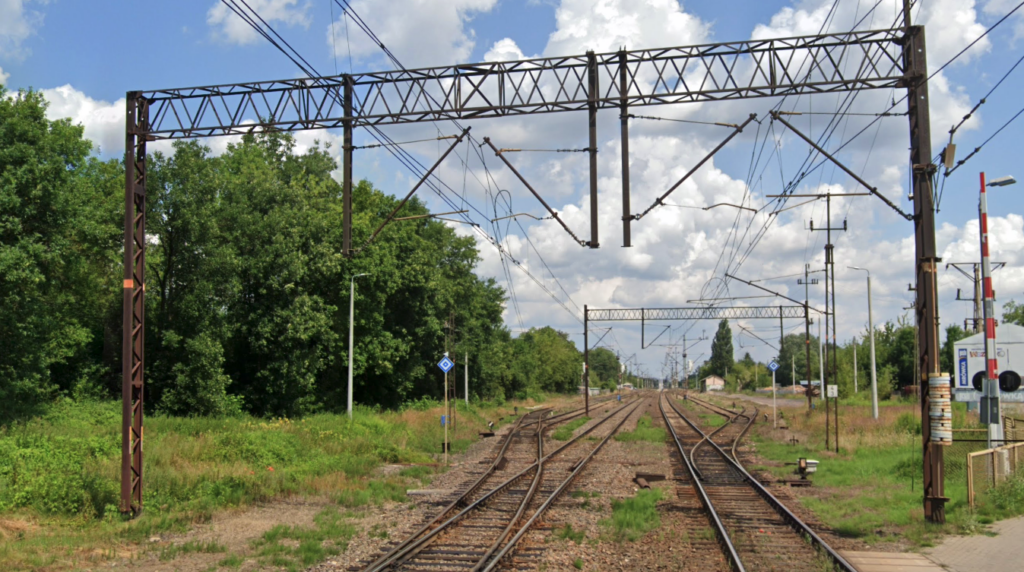
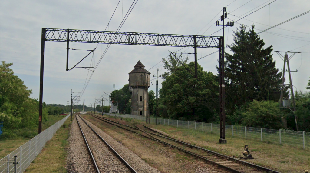
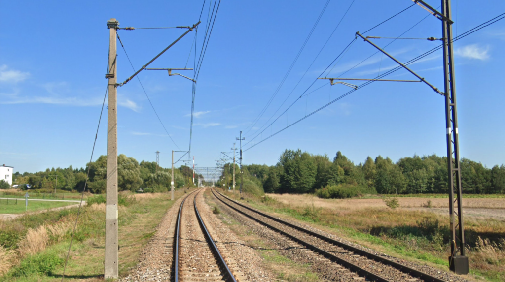
Łuków junction station (0.00 km, elevation 166 m) LCS. Other railway lines: 2, 12, 30. The line curves to the left towards the southwest. The line passes Jana Pawła II Street, Siedlecka Street, Ławecka Street DK No. 63, the Krzna Południowa River, and Parkowa Street. On the west side are Młyny Zborzowe. Łuków Łapiguz station (3.92 km, elevation 166 m). Before the platform is a railway crossing at Warszawska Street DK No. 76. Behind the station is a railway crossing at Żelichowska Street DW No. 807. Świdry was a block post (8.56 km, elevation 164 m). The post was located in the area of a railway crossing of a local road. The village of Świdy is located east of the railway line. The line then runs through the farmland of the villages of Szczygły Górne and Szczygły Dolne. There is a level crossing along Wspólna Street. The line crosses the Bystrzyca River and two railway crossings: Leśna Street and Strażacka Street. Sarnów has a passenger stop (km 14.09, elevation 164 m). Before the platforms, there is a railway crossing on Akacjowa Street, and then another railway crossing. Borowina has a passenger stop (km 16.90, elevation 163 m). Beyond the platforms, there was a railway crossing on a local road. The line enters the forest. Burzew was a former blocking post (km 17.54, elevation 159 m). The line crosses the Mała Bystrzyca River and then two local roads. Krzywda had a station and a passenger stop (km 22.55, elevation 174 m). The station is located in the very center of Krzywda. The station features a historic water tower and a station, which is now the Cultural Center. Behind the station, there’s a crossing along Łukowska Street, the village’s main artery. The line then runs through fields and forests. Huta is a former sectional station (km 26.67, elevation 182 m). Hordzieżka is a passenger stop (km 27.95, elevation 178 m). Behind the platforms, there’s a crossing along a local road. This is the main and only road in the village of Hordzieżka, which is a typical linear village. Okrzeja is a station (km 30.94, elevation 178 m). The station is located in a very small village surrounded by fields and forests. Further along, the line crosses Leśna Street. Grabów Szlachecki is a passenger stop (km 35.26, elevation 179 m). The village is approximately 0.5 km southeast of the stop. Two local roads cross the line. Leopoldów is a passenger stop, a former station (km 42.20, elevation 180 m). Leopoldów is a large, dispersed village, located on both sides of the railway line. Rososz and Oszczywilk are former sectional checkpoints (45 km, elevation 158 m). Janisze was a sectional checkpoint (48.34 km, elevation 143 m). The line approaches the town of Ryki in several curves, overcoming terrain differences ranging from 180 m to 135 m. The line runs under the S17 motorway, then the Zalesianka River, and then under Lubelska Street (DW No. 839). There are industrial areas and factories here, and on the northern side are ponds and a large sewage treatment plant. Ryki is a loading bay and passenger stop, a former station (53.18 km, elevation 135 m). On the northern side, a military siding from a military unit located in the forests runs. Ryki is located on the northern side, approximately 3 km from the station. Stawy station (55.71 km, elevation 128 m). Line No. 579. Dęblin R11 switch (59.67 km, elevation 125 m). Line No. 770. Dęblin station (61.44 km, elevation 119 m). Line No. 7, 579. The track layout allows trains to enter Dęblin station from both sides, facilitating further train dispatch.
Written by Karol Placha Hetman