
Kalety 2026-03-10
The Germans succeeded in building a railway line that connected Wrocław with Silesia. The railway between Wrocław and Kędzierzyn-Koźle was built in stages in the 19th century, as part of the construction of the Germanic railway network. The most important sections of the railway were opened in the following years: In 1842, the Wrocław–Oława line was opened. In 1842, the line was extended to Brzeg. In 1843, the Brzeg–Opole section was opened. In 1843, the line was extended to Kędzierzyn-Koźle. This line was part of the route built by the Upper Silesian Railway (Oberschlesische Eisenbahn). Its main purpose was to connect Wrocław with the Silesian Industrial Region. The route served to transport coal and steel from Upper Silesia and to develop trade within the Prussian state. The railway was operated by the Rechte–Oder–Ufer–Eisenbahn–Gesellschaft company. The project proved highly beneficial and contributed to the development of industry, the economy, and the well-being of society.
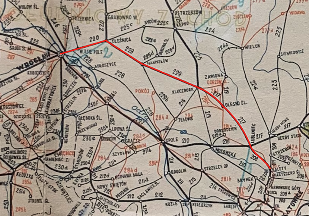
Therefore, the decision was made to build a second railway line, which was to connect Wrocław with Northern Upper Silesia. The Right Bank of the Oder Railway Company was founded. The new railway line was laid through Oleśnica and continued southeastward through: Namysłów – Kluczbork – Olesno – Lubliniec – Kalety, and then southward through: Tarnowskie Góry – Bytom – Chorzów – Siemianowice Śląskie – Katowice Szopienice – Katowice Murcki – Tychy – Pszczyna – Czechowice Dziedzice. The line was built between 1865 and 1872. The Right Bank of the Oder Railway or the Right Oder Railway (in German, Rechte–Oder–Ufer–Eisenbahn, abbreviated ROUE). The Right Bank of the Oder Railway Company was located in a building at 2 Braniborska Street in Wrocław. Currently, it houses the Polish Association of the Deaf and other National Health Fund (NFZ) offices.
This was a time when the Germans fought numerous wars with their neighbors. In 1866, there was a war with Austria, and in 1870-1871, with France. The Germans won both wars. Their victory was due to good logistics and the use of existing railway lines. These Germanic railways provided the German army with the ability to rapidly mobilize and transport troops. The generals of the Prussian General Staff, and after the unification of the Germanic Empire in 1871, the Great General Staff, were skilled at reading maps. They knew that the Oder River divided Silesia in two and was also an obstacle that could be overcome with bridges, which were expensive to build and maintain. In the event of another war with Austria, the left bank of the Oder (south) will be attacked, and in the event of a war with the Muscovites, the right bank of the Oder (north) will be attacked first. The existence of two lines will allow for free maneuvering of the armed forces. The economic benefits of the additional, second railway line were also incidental.
The railway connection to Bytom opened on July 27, 1869. In Bytom, remnants of the former line are visible in the street layout of the northern part of Bytom’s city center. One of the streets that ran along the former track of the Right Bank of the Oder Railway is Józefa Ignacego Kraszewskiego Street in Bytom, along with Aleja Marka Sienickiego and Plac Władysława Targalskiego. Soon after, the first Bytom station of the Right Bank of the Oder Railway was built, located at what is now Powstańców Warszawskich Street 1.
But the Germans started the Great World War and suffered significant losses. The rebirth of the Polish-Lithuanian Commonwealth meant that the Right Bank of the Oder Railway became history. This occurred in 1924, following the division of Upper Silesia between the Polish-Lithuanian Commonwealth and the Germans. The lack of good relations between the Polish-Lithuanian Commonwealth and the Germans influenced the changes in the railway networks in both countries. The Germans perpetuated the idea internationally that Poland was a seasonal country, while within their own society they maintained a different idea: that Poland was planning an aggression against Germanic Silesia. Railway lines would have facilitated an armed attack. These were theories, but the reality was a customs war with Poland and an attempt to destroy the weak Polish-Lithuanian Commonwealth economy.
In Poland, sections of the former Right Bank Oder Railway today comprise, among others, parts of the following lines: Railway Line No. 143 and sections of Railway Line No. 355. Also worth mentioning are Railway Line No. 281 from Oleśnica to Gniezno, which was an initiative of the Right Bank Oder Railway, and Railway Line No. 181 Oleśnica-Wieruszów. This line opened a connection to nearby Syców, 27 km away, in 1871.
In 1855, the Opole-Tarnowitz Railway Company (Oppeln-Tarnowitz Eisenbahn Aktiengesellschaft; OTE) applied to the government of the Kingdom of Prussia for a concession to build the Opole-Tarnowskie Góry railway line and other connections. On November 13, 1865, the government of the Kingdom of Prussia granted the company a concession to build a 128.1-kilometer standard-gauge railway line connecting Wrocław with Vossowska (Fosowskie). The first stage consisted of connecting Wrocław (Nadodrze Station) with Oleśnica. On May 20, 1868, the first service train ran along this route, and on May 28, 1868, passenger service on this section began. Two railway stations, Wrocław Nadodrze and Oleśnica, and other smaller stations along the route were officially opened at that time. The second track on the Wrocław-Oleśnica section was not laid until 1886.
On May 28, 1868, Oleśnica station was opened, and simultaneously the Wrocław-Mikołajów-Oleśnica line was opened. Oleśnica railway station opened on May 28, 1868, on the Wrocław section. The station was built according to the Prussian railway scheme, meaning the station was located between the tracks. Currently, the southern section of the station is a passenger station, while the northern section is a freight station. Oleśnica station is an important point on the railway map of Lower Silesia. Oleśnica gained a railway connection in the second half of the 19th century, which was crucial for the town’s commercial development. In 1871, an important connection to nearby Syców, 27 km away, was launched.
On November 15, 1868, the Oleśnica-Namysłów-Kluczbork line and on to Fosowskie were opened.
Following the establishment of the Right Bank of the Oder Railway (R.O.U.E.) in 1868, running from Wrocław through Oleśnica to Tarnowskie Góry in Upper Silesia, a project arose to establish the Oleśnica-Gniezno Railway. It was intended to shorten the coal transport route from the mines of Upper Silesia to the cities of Pomerania by 75 km. Until then, these cities had been using hard coal exported from England via seaports. This line also had military significance, as it ran along the border with the Muscovite state, specifically the Russian partition of the Kingdom of Poland.
In 1872, the statute of the newly established Oleśnica-Gniezno Railway Company (Oels-Gnesener Eisenbahn-Gesellschaft), abbreviated as KOG, was approved. In Oleśnica, the embankment of this railway track ran near the Oleśnica Castle and crossed the castle grounds, among others, next to the summer house – Lusthaus, founded by the Poděbrady family, and during the time of the Württembergs it was an inn called Monplaisir.
In 1871, construction began on a single-track railway line leading to Milicz, Krotoszyn, Jarocin, and onward to Gniezno. The Oleśnica-Jarocin section was completed on June 30, 1875. The length of this line’s construction was likely due to the Germans’ involvement in the war with France and financial problems. France lost the war and was forced to pay an indemnity of 5 billion gold francs. This amounted to approximately 1,450 tons of gold. The indemnity was planned to be repaid over five years. France repaid it sooner, in 1873. Without a doubt, this money helped revitalize the economy of the new German Empire, but the Germans were still arrogant and haughty.
On June 30, 1875, the single-track line was completed. It was 161 km long and cost over 20 million marks. The route included 14 railway stations and 13 stops. Fourteen freight warehouses were built, five locomotive sheds (approximately every 45-50 km) with 24 locomotive berths, eight steam-powered water stations, and 32 guardhouses and guardhouses. Due to the varying terrain, most of the line ran on embankments (92 km) and through cuttings (54 km), with only 16 km running on level ground. At that time, the Oleśnica Rataje (Rathau) passenger stop was built.
The first stop beyond Oleśnica was in Dobroszyce, with a station and freight warehouse built at kilometer nine. The next stop was in Grabowno Wielkie at kilometer 17.5. Grabowno also served as a station for the town of Twardogóra, as the town was located too high and extending the railway tracks was uneconomical. It wasn’t until 1910 that a track to Twardogóra, Międzybórz, and beyond, which had military significance, was built. A railway station and a freight warehouse were built in Grabowno, which were modernized in 1888 and 1905. In 1910, a water station was built, with a water tower and cranes, which still exist.
At the end of 1875, the KOG’s rolling stock consisted of 25 Prussian steam locomotives, 48 passenger cars (Classes 1, 2, 3, and 4; the cars were distinguished by color), and 456 freight cars. The coal wagons were two-axle with a load capacity of 15,000 kg. The Class 4 wagons were open-top wagons and were relatively quickly decommissioned. Passenger and freight trains ran on the route, and the journey from Oleśnica to Gniezno took 210 minutes, with stops of a few minutes at 12 stations, excluding Oleśnica and Gniezno. The commercial speed was 46 km/h. In Gniezno, passengers had to transfer to a railway operated by another company. To increase passenger capacity, steam cars were introduced. A typical passenger car, equipped with a steam engine, could carry up to 100 passengers and had a speed of 40-50 km/h. The cars had three or four axles, with one or two drive axles.
In 1886, the Oleśnica-Gniezno Railway was nationalized through its purchase. Until then, the KOG (Communist Railway Company) had its headquarters in Oleśnica. This was based on an 1879 act that nationalized previously private railway lines in Germanic territory. Between 1875 and 1886, three railway stations operated in Oleśnica.
The next project was a railway connection between the Germanic and Muscovite brothers, which was intended to increase trade between the two empires. Several concepts for this connection were developed. The concept lobbied for by Wrocław prevailed. The plan was to build a railway connection between Wrocław and Warsaw (Breslau-Warschauer-Eisenbahn, a railway line). This included the construction of a route from Oleśnica to the Podzamcze border station (Wilhelmsbruck, now Wieruszów). On March 12, 1870, Emperor Wilhelm I approved a concession for the construction of a 58-kilometer railway line from Oleśnica to the Wilhelmsbruck (Podzamcze) border station.
On November 10, 1871, the Oleśnica-Syców line was opened. It was constructed in stages. The first section, from Oleśnica to Syców, officially opened on November 10, 1871. On March 1, 1872, the section from Syców to Kępno was completed, and on May 26, 1872, the entire line from Oleśnica to the Podzamcze border station (now a suburb of Wieruszów). The line was built by a joint-stock company. The company’s headquarters was in Syców. Unfortunately, due to the lack of interest from the Muscovites in this connection, this line played a secondary role. It was built as a single-track line, and a second track was never added. After World War II, the line was not electrified.
In 1908, construction began on a railway line from Grabowno Wielkie towards Twardogóra, Międzybórz, and onward to Ostrów Wielkopolski. This line does not begin in Oleśnica, but is closely connected to Oleśnica. A switch was placed at Grabowo Wielkie station, leading the lines eastward. Stations were then built at Twardogóra, Bukowina Sycowska, and Międzybórz Sycowski. The line then turns north. Additional stations include Pawłów Wielkopolski, Sośnie Ostrowskie, Granowiec, Barki, and Odolanów. The line curves east-north. Additional stations include Tarchały Wielkie and Ostrów Wielkopolski. The line is 53.9 km long. It was completed in 1910. It was a typically Germanic line and was intended to boost the economic development of the area. The line failed to meet this requirement, as the Germans started the Great World War, and in 1918, the Pawłów Wielkopolski-Ostrów Wielkopolski section of the line became part of Poland. After World War II, which was re-initiated by the Germans, the entire line became part of Poland. The line was electrified. Currently, the line is part of Line No. 355. Between 2024 and 2026, work was carried out to restore the line’s technical parameters, including track replacement and modernization of crossings and platforms.
In 1941, under the supervision of the Wehrmacht, construction of the Łukanów-Dąbrowa Oleśnicka link began. The initial section near Lucień was built by 400 prisoners of war from the Lucień camp. The link was intended to shorten travel times from Wrocław towards Krotoszyn and Ostrów Wielkopolski and allow the Oleśnica station to be bypassed.
On July 19, 1945, after wartime destruction, the Wrocław Nadodrze-Oleśnica railway line reopened. A temporary bridge was built over the Widawka River between the Wrocław Nadodrze and Wrocław Psie Pole stations. The bridge was 92 meters long and rebuilt within 21 days. German prisoners of war, sent by the Soviets from their camp, participated in the work. This provided Wrocław with a connection to Katowice, Łódź, and Warsaw. In place of the temporary wooden bridge, a concrete and steel bridge was opened in 1947.
On August 20, 1945, Polish Railway Workers officially took over the Oleśnica station, which had been temporarily administered by the Soviets. By 6:00 PM, all posts were clear of Russians.
On January 25, 1946, the rebuilt truss bridge over the Odra River, between Wrocław Główny and Wrocław Nadodrze, was opened. This allowed trains to reach the center of Wrocław.
Railway Line No. 143 Kalety – Wrocław Popowice.
Railway Line No. 143 Kalety – Wrocław Popowice. This route is of national importance, double-track, and electrified. Oleśnica lies at km 133.69 of the route. The line runs through the Silesian, Opole, and Lower Silesian Voivodeships. The sections that make up the current line are: On May 28, 1868, the Wrocław Nadodrze – Oleśnica section was opened. On November 15, 1868, the Oleśnica – Kluczbork section was opened. On July 1, 1883, the Kluczbork – Olesno Śląskie section was opened. On May 1, 1884, the Olesno Śląskie – Lubliniec section was opened. On October 15, 1884, the Lubliniec – Kalety section was opened. In 1906, the Wrocław Mikołajów station was opened. On September 7, 1972, the line was electrified. Between 2012 and 2015, the Kluczbork – Kalety section was modernized. Since 2015, the Oleśnica – Wrocław Psie Pole section has been modernized. Since 2018, work has been underway to remove permanent 30 km/h speed restrictions (viaducts and culverts). This allowed passenger trains to maintain a constant speed of 120 km/h. Two new passenger stops have been created: Pielgrzymowice, 116.76 km of route, and Mirków, 150.17 km of route (due in 2023).
Railway line No. 143 is 163.369 km long. The line is double-track and electrified with 3 kV DC. The maximum train speed is 120 km/h. The track gauge is 1435 mm. The line runs through the following voivodeships: Silesian, Opole, and Lower Silesian Voivodeships.
The line was opened in sections: On October 15, 1884, the Kalety – Lubliniec (ROUE) section was opened. On May 20, 1884, the Lubliniec – Olesno Śląskie (ROUE) section was opened. On July 1, 1883, the Olesno Śląskie – Kluczbork (ROUE) section was opened. On November 15, 1868, the Kluczbork – Oleśnica (ROUE) section was opened. On May 28, 1868, the Oleśnica – Wrocław Mikołajów (ROUE) section was opened. In 1906, Wrocław Mikołajów station opened.
The second track was opened. In 1908, Kalety – Namysłów (KPStE – Royal Prussian State Railways). In 1893, Namysłów – Wrocław Mikołajów (KPStE – Royal Prussian State Railways).
Electrification; On September 7, 1972, Kalety – Oleśnica (PKP). On July 20, 1972, Oleśnica – Wrocław Mikołajów (PKP).
Railway line No. 143 Kalety – Wrocław Popowice (Wrocław Mikołajów) is one of the key lines for the future of Wrocław’s railway network. The Wrocław section of the line is one of the busiest. Routes from Oleśnica, Jelcz Miłoszyce, and Trzebnica converge here. The line also runs through one of Wrocław’s major stations, Nadodrze. It experiences significant passenger and freight traffic.
As early as 2010, public concerns arose about the need to rebuild rail traffic for the elderly and schoolchildren, enabling access to hospitals, schools, and universities. The authorities were asked to renovate the railway line, at least as far as Oleśnica. Renovation projects were developed, but these had to wait for implementation. In 2012, the government explained that an environmental decision and project conditions had already been issued for the entire Kluczbork – Oleśnica – Wrocław Sołtysowice – Wrocław Mikołajów section. In reality, these documents were not issued until 2022. Apparently, the program was moved to the reserve list already in 2012. It should be noted that at that time, Poland was governed by a coalition of the Civic Platform and the Polish People’s Party (PSL). This same coalition, known as the Civic Coalition – PSL, returned to power on December 13, 2023, a symbolic date in Polish history.
It is worth noting that reports have emerged that the Wrocław – Oleśnica line should receive a third track, or perhaps even a fourth. According to information provided by the Polish Railway Line (PLK PKP PLK), the project does not include the construction of a third track in Wrocław. However, as part of the “Preliminary Feasibility Study for the Wrocław Railway Junction” currently being developed, the extension of railway line No. 143 by two additional tracks is being analyzed, the Ministry of Infrastructure announced in 2022.
Between 2012 and 2015, work began on preparing a plan to modernize the Kalety-Kluczbork section of the line. The total project value was expected to exceed PLN 400 million. On July 27, 2015, PKP PLK signed an agreement with Trakcja PRKiI for the revitalization of the Oleśnica-Wrocław Psie Pole section. However, preparation of the work took a very long time. On January 24, 2018, PLK PKP signed an agreement with Sytra S.A. for the modernization of the Kluczbork-Wrocław Mikołajów section. The contract value was PLN 17 million. However, this was very low funding and practically covered only maintenance costs. On March 27, 2018, PLK PKP signed an agreement for the revitalization of Track No. 1, on the Kluczbork-Namysłów, Namysłów-Bieruń, and Bieruń-Oleśnica sections. This track was in worse condition because it had wooden sleepers, many of which were in poor condition.
The modernization of Railway Line No. 143 began in 2021, during the United Right government. The communist, liberal, and Volksdeutsche governments showed little interest in improving the condition of Poland’s railway network. On the contrary, they eliminated passenger trains, created unfavorable timetables, and closed railway lines and stations. Between 2021 and 2026, PLN 538,569,117.58 was allocated for the modernization of Railway Line No. 143. Reportedly, some of the funds were obtained from EU funding.
On July 25, 2025, a contract was signed between PLK PKP and Trakcja. The revitalization of the Bierutów – Oleśnica section (from 120.490 km to 132.542 km) cost PLN 288 million. The axle load was increased to 221 kN. Train speed was increased to 120 km/h for passenger trains and 80 km/h for freight trains. As part of the work, modern platforms were constructed at the Solniki Wielkie stop. Nineteen engineering structures, including bridges, viaducts, and culverts, were renovated. Twelve level crossings were rebuilt. The rails were replaced with contactless rails manufactured by ArcelorMittal Poland, Dąbrowa Górnicza. The overhead contact line and railway traffic control systems were modernized. Stops were adapted for disabled access. Safety was improved.
The Kluczbork – Wołczyn section was renovated (from km 71.366 to km 81.800). The modernization cost PLN 312 million. The work was carried out in 2025-2026. The track profile was improved. The track bed and sleepers were replaced from wooden to pre-stressed concrete. Embankments were reinforced on some sections. 14 culverts were modernized and drainage ditches were improved. Platforms were constructed at the Solniki Wielkie and Smardy stations. Three railway viaducts and three railway bridges were modernized. The overhead lines were replaced. Lighting at passenger stops was improved. SKR, communication, and technical equipment were modernized. The semi-automatic blocking system on the Kluczbork – Wołczyn section was modernized. 15 level crossings were modernized. CCTV, street lighting, and a signaling system were installed at these crossings, and new barriers were installed. Axle load was increased to 221 kN. Train speed was increased to 120 km/h for passenger trains and 80 km/h for freight trains.
LK No. 143 has numerous stops and stations with distinctive platforms. There are two narrow, single-sided platforms. The second platform is located between the tracks, and from there, you board the train, which travels on the next track.
There are 28 railway bridges along the route, the largest of which are in Wrocław. There are 32 rail-road viaducts along the route. There is one rail-road viaduct. There are four pedestrian footbridges over the tracks. There are as many as 75 rail-road crossings of various categories, from A to F, along the route. The crossings are primarily category C (red lights, audible signal, no barriers) and category B (half barriers, red lights, audible signal). On lines with speeds up to 120 km/h, category A, B, C, and D crossings are possible, although B and C are most common.
The route of railway line No. 143 Kalety – Wrocław Popowice WP2.
Kalety station (0.00 km, elevation 273 m). Other railway lines: No. 129, 130, 131. The station has two platforms and three platform edges. There are eight through tracks. Behind the platforms, the viaduct of DW No. 789, Koszęcińska Street, passes over the tracks. LK No. 143 departs northbound. There is a switch: to the right is the Coal Main Line, to the left is LK No. 143. The line runs through forests. The line has a slight northwesterly curve. The line crosses the Dubieski Potok River. The line crosses DW No. 907, Sobieskiego Street, at the top. The line crosses the Leśnica River.
Koszecin station (7.40 km, elevation 277 m). At the southern station head, the line crosses Piaskowa Street at the top. There is a brick water tower. There are two platforms, three platforms, and a station building. The building is two-story, with a basement and a developed attic. The station used to have a siding and storage yards. Behind the station is the Józefa Bema Street crossing. Further on, there is the Dąbrówki Street crossing. The line re-enters the forest. Further on is the village of Rusinowice; below it passes 1 Maja Street, followed by the crossing and Kolejowa Street.
Rusinowice passenger stop (km 13.32, elevation 272 m). Here, you’ll find the station building, two single-track platforms, and a crossing between them, Dworcowa Street. The line runs through farmland. The Lubliniec railway junction begins. A double-track railway line runs overhead to Pyskowice. Beyond the viaduct, a single track from the line from the Pyskowice direction joins from the south. The line crosses the Droniowicki Stream. There’s a crossing, Droniowicki Street. From the north, the line from Częstochowa and the right-hand track from the Pyskowice direction join. There are seven main tracks in total. The tracks cross the Lublinica River and the surrounding ponds (Staw Fabryczny). The Lubliniec “LcA” signal box is located. The tracks pass under Voivodeship Road No. 906, Powstańców Śląskich.
Lubliniec station (km 19.25, elevation 260 m). Other railway lines; No. 61, 61i, 61j, and 152. The station has two platforms, four platform edges, a station building, and a locomotive shed. The station is modern, attractive, and connects to the bus station. There is a modern multi-story parking lot. At the northwest end of the station is a crossing, Częstochowska Street, and the “LcB” signal box. The tracks split; to the west, a single track branches off to the Kolonowskie/Fasowskie station. To the northwest, runs LK No. 143. Further on, on the eastern side, is the PKP Energetyka plant and the former overgrown station plain. Beyond is an unfinished viaduct, of which only concrete abutments and a railway embankment remain. This is an unfinished Germanic railway line from World War II, meaning the second track to the Kolonowskie/Fasowskie station. Further on, there is a crossing, Witosa Street, and another crossing, Księdza Szramka Street. There are farmland. The line passes under national road no. 46, Kochanowiska Street.
Kochcice-Glinica passenger stop (km 24.36, elevation 258 m). The Polish-German border is 27.40 km away. There are two single-edge platforms facing each other, a “KG” guard post, a parking lot, and a crossing on Kochcicka Street. Further on, there is another crossing on Boczna Street, another crossing on a local road, and another crossing on Brzezinkowe Street. Further on, there are forests and a crossing on a forest road. There are ponds in the area.
Ciasna station (km 29.60, elevation 245 m). The station has two single-level platforms, three through tracks, a station connected to a warehouse, and the “Csa” signal box. Beyond the platforms is a crossing on Zjednoczenia Street. Further on stands a brick water tower, and a timbered reservoir. The Forests on the Upper Liswarta Landscape Park is home to railway ponds. There are farmland and crossings on Nowy Dwór Street, Wiejska Street, Cegielniana Street, and Ceramiczna Street.
Sieraków Śląski station (km 34.99, elevation 248 m). It has two single-level platforms, a two-story station with a signal box, four through tracks, and a siding. Wyzwolenia Street runs below the station. There is a crossing on Długa Street. The line enters the forest. It is the border of the Silesian and Opole Voivodeships. Further on, the line passes over Jana Dzierżonia Street. There are level crossings: Józefa Lompy Street and Wydzieracz Street. The line passes under the S11 highway.
Sowczyce station (km 43.45, elevation 250 m). There are two single-edge platforms, a station, and three through tracks. Behind the station, Długa Street passes under the line, followed by another viaduct, Oleska Street. The line enters forests and wasteland. The line passes under a local road viaduct. There is a level crossing, Wygodzka Street. The city of Olesno.
Olesno Śląskie station (km 50.13, elevation 242 m). Line No. 196. Before the station, there is a level crossing, Voivodeship Road No. 494, Częstochowska Street. At the southeast station head, Voivodeship Road No. 487, Izydora Murka Street, passes under the line. The station has two platforms and two platform edges. There is a large station building, six through tracks, and sidings. Further on, there is a footbridge over the pedestrian tracks. The line leaves Olesno and enters the forest. The line crosses Wilcza Street. Highway No. S11 runs to the northeast.
Stare Olesno passenger stop (km 55.20, elevation 220 m). There are two single-track platforms, a station, and a crossing on Kolejowa Street. The line then passes under highway No. S11 and continues through the forest.
Bąków station (km 61.75, elevation 202 m). There are two single-track platforms, a station, the “Bąk” signal box, and five through tracks. Beyond the station is a crossing on Wolności Street, and then a crossing on national road No. 11. The line then turns westward. The line passes the Stobrawa River. The line continues through the forest. Further on, there is a crossing on Strzelecka Street. The line enters the town of Kluczbork. There’s a crossing, Opolska Street. From the north, a single-track line from Opole approaches. At the fork of the line is an old locomotive shed.
Kluczbork station (70.12 km, elevation 183 m). Lines No. 143b, 175, 272, and 293. There is a level crossing, Jana Dzierżonia Street, and a footbridge over the tracks. The Stobrawa River flows below. There is a large fan-shaped locomotive shed. There are four platforms, with an island station between them. There is a water tower and the Ty45-149 technical monument. The Młynówka River flows under the tracks. The tracks pass under a viaduct, Wołczyńska Street, from which there is an exit to the station. A freight station begins. The lines split; one runs north to Kępno, the other, LK No. 143, runs west. The line passes over national lines No. 42 and 45. The line crosses the Baryczka River. Smardy was a branch line (km 73.91, elevation 178 m). Line No. 767.
Smardy passenger stop (km 74.70, elevation 177 m). Before the platforms, there is a level crossing, Wielka Street. There are two single-level platforms and a station. Further on are farmland and more forests.
Wołczyn station (km 82.16, elevation 166 m). Before the station, there are two level crossings: Kluczborska Street and Opolska Street. There are two single-level platforms, a station, signal boxes, seven through tracks, and sidings to factories, including Lesaffre Polska. Further on, the line crosses the Wołczyński Strumień River. There are three local road crossings and farmland.
Wierzbica Górna passenger stop (km 87.20, elevation 172 m). There are two single-level platforms and a station. Further on are two streams; Czarna Woda, Włochy Potok. Duczów Wielki was a passing loop (km 88.59, elevation 169 m). There is one local road crossing. There is also a crossing on National Road No. 42.
Domaszowice station (km 94.27, elevation 166 m). There are two single-track platforms, five through tracks, a station, a signal box, a crossing, Strzelecka Street.
Gręboszów passenger stop (km 100.46, elevation 170 m). There are two single-track platforms, a station, and a crossing, National Road No. 42. Gręboszów was a station, then a passing loop. Currently, the station level area has no tracks and is overgrown with grass and self-seeded weeds. Further along are farmland. There are two railway crossings and local roads.
Namysłów station (106.46 km, elevation 152 m). Railway lines No. 301, 307. In Namysłów, a railway line from Kępno ran from the north, passing along Railway Line No. 143 and reaching the station from the south; Railway Line No. 307. Another disused railway line ran from the south of Jełów to Opole Główne; Railway Line No. 301. Further on, there are level crossings; Łączyńska Street, Józefa Piłsudskiego Street. A viaduct passes over the tracks, Jana Pawła II Street. The station has two platforms, three platform edges, a station, a locomotive shed, and a railway water tower. There are eight through tracks and sidings. Behind the station, there are two level crossings; Bolesława Chrobrego Street, Józefa Ignacego Kraszewskiego Street. The line crosses the Młynówka and Widawa rivers. There is one level crossing and a local road. Further along is the Jaskuła River.
The Wilków Namysłowski passenger stop (km 111.09, elevation 154 m). There is a station, two single-sided platforms, arranged in a passing loop, and a crossing between them, Kolejowa Street. There are agricultural areas. The line crosses several rivers, including the Dopływ z Wojciechowa (Flower Stream) and the Dopływ z Bukowo (Flower Stream) River. There is a crossing, a local road. The Opole/Lower Silesian Voivodeship border is 117.79 km away. There are three crossings: Namysłowska Street, Ogrodowa Street, and Stefana Żeromskiego Street.
The Bierutów station (km 119.87, elevation 147 m). There are two single-sided platforms, five through tracks, a station, and signal boxes “Br” and “Br1.” There are crossings: Wodna Street and Solnicka Street. There are five crossings in total, primarily for agricultural purposes.
Solniki Wielkie passenger stop (km 126.77, elevation 154 m). There are two single-edge platforms and a station. Nearby, on the south side, passes DW No. 451. Further on, there is a crossing, DW No. 451. There are still agricultural areas. Further on, the line passes over a local road. The line crosses the Smolna River. There is a crossing on a local road. There are two crossings on dirt roads and another crossing on a local road. The line crosses the Świerzyna branch. There is a crossing, a dirt road. Already in Oleśnica, the line crosses Trakcyjna Street at the top.
Oleśnica station (km 133.69, elevation 158 m). Lines 181 and 281. Oleśnica station, on the side of line 143, begins with the freight wagon repair plant. The line passes under the viaduct at Wądoły Street. Line 181 joins from the north. The station has a passenger section on the south side and a freight section on the north side. The station is an island-type structure, joined by Kolejowa Street on the west side. Behind the station, the tracks cross 3 Maja Street. Line 143 runs southwest, while the single-track line 281 turns north. Then, line 143 crosses the disused Cegielniana crossing and crosses Wiejska Street.
Łukanów station (km 137.01, elevation 146 m). Line No. 776 is a connecting line with Line No. 281, allowing trains from Wrocław to bypass Oleśnica station. There is a level crossing, Wiejska Street. Further on, there are agricultural areas. A level crossing, Główna Street. The Oleśnica River. Level crossings: Topolowa Street, Lipowa Street.
Borowa Oleśnicka station (km 141.71, elevation 133 m). There are two single-edge platforms, a station, and five through tracks. Further on, the line enters the forest. There is a Topór River. Level crossing, Kamienna/Kasztanowa Street. Level crossing, Żwirowa/Przemysłowa Street. The next level crossing, Betonowa Street.
Długołęka station (km 147.62, elevation 130 m). First, there is a freight station. Then, there is a level crossing, Robotnicza Street. The passenger station has two single-edge platforms and three through tracks. Level crossings; Władysława Broniewskiego Street, Wiejska Street. The line crosses the Topór River. The line passes under Voivodeship Road No. 372, the Wrocław Eastern Bypass.
Mirków passenger stop (km 150.07, elevation 130 m). There are two single-track platforms facing each other. There is a crossing on Kiełczowska Street. The line then enters Wrocław. The line passes under Bierutowska Street. The line runs along Voivodeship Road No. 372, Aleja Jana III Sobieskiego, which is on the northern side, and then passes under this road. The line on the northern side is joined by a single-track line from Trzebnica, LK No. 326.
Wrocław Psie Pole station (km 153.74, elevation 123 m). LK No. 326. There are three through tracks, two single-track platforms, and a station. The line then passes under the viaduct of Generała Tadeusza Bora-Komorowskiego Street. A pedestrian bridge over the tracks follows. The line then crosses the Widawa River. From the south, a single-track line from Jelcz Miłoszyce station, LK No. 292, joins, continuing northwards to Wrocław Osobowice.
Wrocław Sołtysowice station (km 156.60, elevation 118 m). Line No. 292. There are three platforms and three platform edges. Beyond the platforms is a crossing, Aleja Porzeczna Street. Further on is the freight section of the station. The crossing, Piotra Czajkowskiego Street. The line gradually turns south. The line passes over Tadeusza Boya Żeleńskiego Street. There is a railway bridge over the Stara Odra River and another bridge over the Odra Canal.
Wrocław Nadodrze station (km 160.53, elevation 119 m). First, there is a large freight station, then the tracks cross Trzebnicka Street and a passenger station. There are two platforms and three platform edges. The line heads west again, passing Łowiecka Street. Further on, there are switches to the Odra River port. There is a railway bridge; the Stary Railway Bridge over the Odra River.
Wrocław Szczepin passenger stop (km 161.92, elevation 120 m). There are two single-track platforms. Behind the platforms is a viaduct over Długa Street. On the south side, there is a siding to the military storage base; km 162.20.
Wrocław Popowice WP3 checkpoint (km 162.65, elevation 120 m). Railway lines No. 752, 755. From this point, the line is considered single-track, although it permanently runs on two tracks. There is a switch, and Railway line No. 143 turns from west to south. The line crosses Ścinawska Street. From the north, the tracks of the Wrocław Główny – Poznań Główny railway line join. There is a local control point (LCS). The line crosses Legnicka Street.
Wrocław Mikołajów WP2 passenger stop, checkpoint (km 163.64, elevation 119 m). LK No. 271, 756, 769b.
Written by Karol Placha Hetman