Pisz 2023-01-03
PKP Orzysz, Ełk, Biała Piska, Pisz.

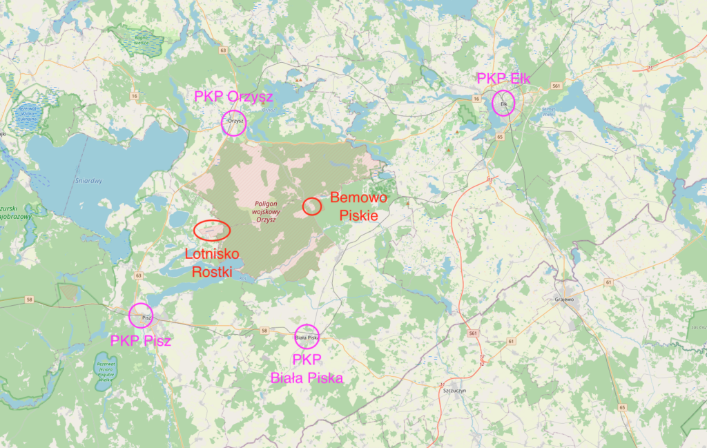
The area we are interested in is located in a quadrangle defined by four cities: Orzysz, Ełk, Biała Piska, and Pisz. This area lies in Masuria and for most of its history belonged to the Polish Crown, and later to East Prussia, which was seized in 1772 by Germanic tribes after the murder of the indigenous inhabitants – the Yotvingians and Prussians. Subsequently, it was the Prussian Province from 1772 to 1871, Prussia from 1871 to 1918, the German Empire from 1919 to 1933, and the Weimar Republic (Third Reich) from 1933 to 1945. During the Great World War, from 1914 to 1915, the Great Lakes region was occupied by the Muscovites. Despite the Germans losing the war, East Prussia remained under German administration. In 1920, a plebiscite was held among the local population, which voted in favor of belonging to East Prussia. As a result of World War II, initiated by the Germans and the Muscovites, in 1945 the area was incorporated into the Republic of Poland. Administratively, it falls within the Warmian-Masurian Voivodeship.
At the beginning of the 20th century, the Orzysz military training ground was very well connected by rail. The station in Pisz opened on November 15, 1884. The Biała Piska station opened in 1885. The station in Orzysz opened in 1905. Standard-gauge railway lines ran along virtually every side of the military training ground. These lines were established with state support, aimed at developing the most backward parts of East Prussia and enabling Muscovy to import goods from the Middle East.
The town of Orzysz.
Orzysz gained its municipal status in 1725. The town has an area of 8.17 square kilometers. The population in 2014 was 5,797, and in 2017, 5,615. On November 12, 1946, the town was given the Polish name Orzysz, a Polonization of the Latin name. The town’s development dates back to the 16th century, in connection with the trade route from Warmia towards Belarus. The town typically developed along the main trade route. It was part of the Crown of the Kingdom of Poland, as a fiefdom. In 1701, it was occupied by the Prussians, becoming the Kingdom of Prussia. Although the majority of the inhabitants spoke Polish, and masses were celebrated exclusively in Polish, Germanic settlement began in 1702. As late as the mid-18th century, the majority of the population were Poles. From 1871 to 1945, the town of Orzysz was incorporated into the Germanic borders.
In 1890, a military training ground was established near Orzysz, and in 1895, the town became a garrison town. The stationing of the Prussian army in the town contributed to its stable development. From November 1914 to February 1915, the town was occupied by the Muscovites. Between January and February 1945, the residents of Orzysz were victims of crimes committed by the Muscovites. French prisoners of war and other war refugees also died.
After 1946, the military facilities in Orzysz were occupied by the Polish Army. Military units stationed here included the 32nd Operational-Tactical Missile Brigade, the 32nd Missile and Artillery Specialist Training Center, the 7th Disciplinary Unit – Military Unit 1370 (until 1991), the 4th Armored Cavalry Brigade, the Lithuanian-Polish Peacekeeping Battalion, the 15th Giżycko Mechanized Brigade, and the 15th Masurian Engineer Battalion.
During the Polish People’s Republic, a military unit, the 7th Disciplinary Unit, operated in Orzysz, which was incorrectly described as a penal unit. Soldiers who had a hostile attitude toward compulsory military service served in the unit. All soldiers were trained in accordance with applicable regulations.
PKP Orzysz.
Address: Kolejowa Street, 12-250 Orzysz, Poland. Geographic coordinates: 53.804N 21.938E. Elevation 125 m.
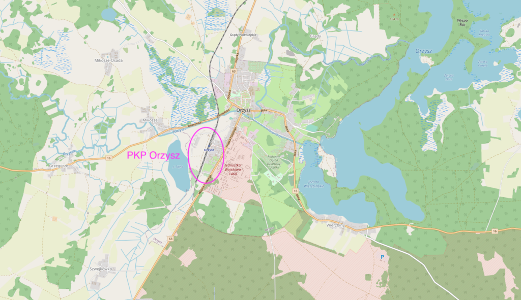
Orzysz received its first railway connection in 1906-1908. This was a longitudinal railway line, Giżycko-Pisz. The route passed through the following towns: Upały-Ruda Staświny-Miłki-Konopki-Ublik-Pianki-Orzysz-Nowe Guty-Trzonki-Snopki-Pisz. The line connected two important east-west routes: Korsze-Ełk and Olsztyn-Ełk. The first Giżycko-Orzysz section opened on June 1, 1906. This explains why the Orzysz railway station is located longitudinally. In 1945, the Muscovites dismantled the line and transported it to Moscow.
In 1911, the Mrągowo-Orzysz-Ełk railway line was built, creating a third latitudinal line: Czerwonka-Ełk. Orzysz thus became a junction station. However, due to the theft of the Giżycko-Pisz line in 1945, Orzysz was left with only one latitudinal railway line, and, in addition, the train head was changed at Orzysz station. In 2009, passenger traffic on this line was suspended. In 2018, the railway station was renovated. The military railway ramp, used for transporting military equipment to the Orzysz-Bemowo Pilskie training ground, was renovated.
The town of Ełk.
Ełk is the largest city in the region. The city was founded in 1425 and granted city rights in 1445. The city has an area of 21.05 square kilometers. The population is 61,903 (2020). The city is located in the Warmian-Masurian Voivodeship. The current name Ełk was approved on May 7, 1946. Ełk is located in the Ełk Lake District, which is part of the Masurian Lake District. The city lies on Lake Ełk, Lake Sunowo, and the Ełk River, a tributary of the Biebrza River.
In 1398, a brick castle was built in Ełk, and settlement developed nearby. The city received its charter in 1435. In 1454, Ełk joined the Prussian Confederation. Under the Treaty of Thorn in 1466, Ełk became part of the Kingdom of Poland, remaining a fiefdom under the Teutonic Knights’ rule. After the secularization of the order in 1525, it fell under the rule of the secular Prussian princes.
During the Great War, Ełk suffered extensive destruction, particularly in the period 1914-1915. During World War II, Ełk and its surrounding area were subjected to forced labor for many citizens of occupied countries. On January 24, 1945, the Red Army entered the abandoned city of Ełk. The Muscovites plundered and destroyed 50% of the city. The city was handed over to Polish administration on April 6, 1945. On June 8, 1999, Saint John Paul II the Great visited the city.
PKP Ełk.
Address: Jarosława Dąbrowskiego Street 16, 19-300 Ełk, Poland. Geographic coordinates: 53.825N 22.363E. Elevation: 127 m.
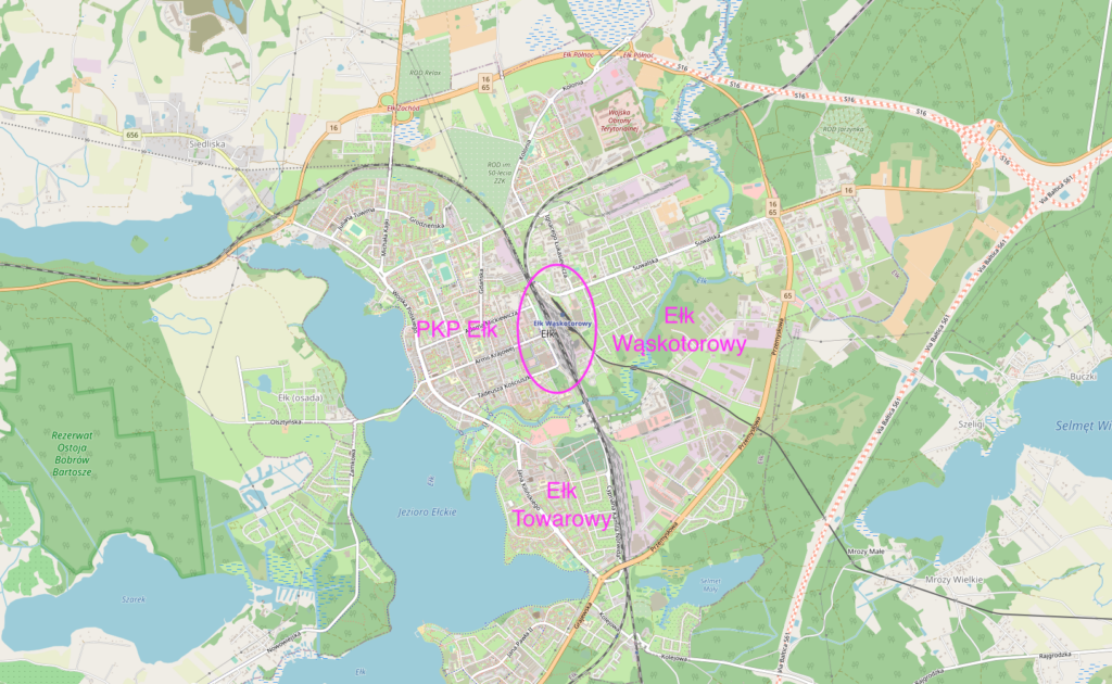
In 1868, the city of Ełk gained a railway connection with Królewiec, via Kętrzyn and Giżycko. The route then ran south to the border with the Russian partition. The railway junction in Ełk, by Masuria’s standards, is a large and important railway junction. Its history began on December 8, 1868. In 1879, Ełk station became a junction. In subsequent years, additional routes were built, resulting in a five-track station. All routes are single-track, although some sections were double-track until 1945. All three latitudinal routes converged at Ełk station: from Królewiec to Korsze, from Czerwonka station, and from Olsztyn to Szczytno to Pisz.
The electrification of Ełk station took place in December 1990, when electric traction was installed from the Grajewo side. Further electrification was planned through Giżycko, Kętrzyn, and Korsze, as well as the Biała Piska, Pisz, Ruciane Nida, Szczytno, Pasym, and Olsztyn Główny lines. Currently, electrification of the Giżycko-Ełk section is underway. Until May 1992, the entire Ełk junction was served by steam traction, with a small amount of diesel traction. In the 1980s, Elbląg station was one of the largest steam locomotive depots.
Currently (2023), the Ełk railway station and Ełk freight station are undergoing major renovations. Grade-separated rail-road intersections are being constructed. A new track system, new platforms, and a new railway control system are being built. In the near future, all trains on the Ełk – Korsze section will be pulled by electric locomotives.
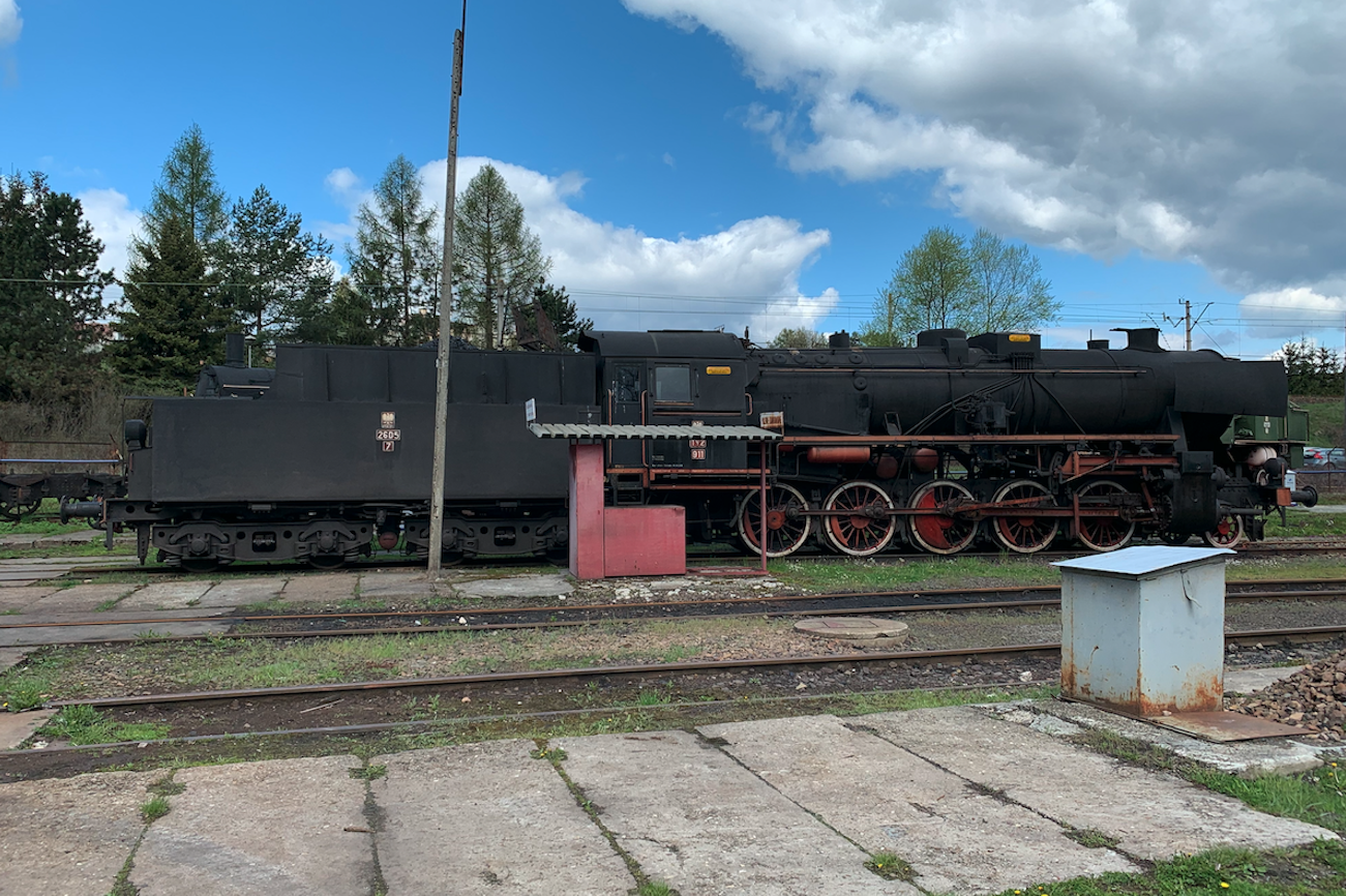
In 1913, the Ełk Narrow Gauge Railway was launched. This railway operates to this day (2023) as a tourist railway.
PKP Biała Piska.
Address: Kolejowa Street 3, 12-230 Biała Piska, Poland. Geographic coordinates: 53.614N 22.068E. Elevation 138 m.
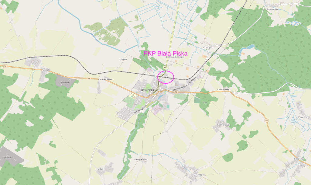
Biała Piska is a city in the Warmian-Masurian Voivodeship. The settlement was founded in the 15th century and granted city rights in 1722. The city has an area of 3.24 square kilometers. The population is 4,083 (2016). The construction of the Ełk–Pisz railway line in 1883 led to the city’s development.
PKP Pisz.
Address: Dworcowa Street 12, 12-200 Pisz, Poland. Geographic coordinates: 53.631N 21.793E. Elevation 115 m.
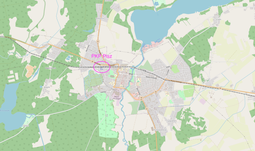
Pisz is a city in the Warmian-Masurian Voivodeship, founded in 1367 and granted city rights in 1645. The city has an area of 10.08 square kilometers (3.9 square miles). The population was 19,386 as of 2017. The city is surrounded by the Pisz Forest and lies on the Pisa River. During the Great War, the city was destroyed twice by the Muscovites. During the post-war plebiscite, the majority of residents voted to remain within German borders. In January 1945, the Muscovites entered the city and destroyed 70% of it.
In 1884-1885, Pisz gained rail connections with Olsztyn and Ełk. At that time, of the district’s 49,000 inhabitants, as many as 37,000 were Poles. In 1905, the local railway line between Pisz and Orzysz was built.
The water tower at the Pisz station dates back to 1919. It has an unusual shape.
Railway Line No. 38: Białystok – Głomno.
Railway Line No. 38: Białystok – Głomno is single-track, partially electrified. Length: 241.453 km. Maximum speed: 120 km/h. Historically, the line belonged to the Prussian Railways. It was the first parallel line through Masuria. The first section, Königsberg – Bartoszyce, was opened on September 24, 1866. The next section, Bartoszyce – Kętrzyn, was opened on November 10, 1867. The Ełk – Kętrzyn section was opened on December 8, 1868. The Ełk – Prostki section (then the Prussian-Russian border station) opened on November 1, 1871. The Russians opened the Białystok – Grajewo section (broad gauge) on September 15, 1873. The Grajewo-Prostki section had two tracks: standard gauge and broad gauge. However, the main freight transshipment took place at Prostki station. In 1894, the Korsze-Ełk line received a second track. The Królewiec-Korsze and Ełk-Prostki sections were also double-tracked.
In 1918, during the winter of the Russian Partition, the lines returned to the reborn Poland, and the broad gauge tracks were converted to standard gauge. In 1945, the second track on the Korsze-Prostki section was stolen by the Muscovites as spoils of war.
The electrification plan for the Ełk-Giżycko section was announced in 2020. The contract was signed on December 7, 2021. The contract is worth approximately PLN 680 million. Electrification involves the complete modernization of the tracks, stations, level crossings, and other facilities. Work began on March 13, 2022. Due to the work, InterCity trains “Mamry” and “Niegocin” have been shortened from Kętrzyn to Giżycko station. The Korsze-Giżycko section has also been slated for modernization, including electrification. This is planned for 2025-2027.
Railway Line No. 223: Czerwonka – Ełk.
Railway Line No. 223 Ełk – Orzysz – Mikołajki – Mrągowo – Czerwonka. Line length: 121.616 km. This line was the third latitudinal line through Masuria. The line is primarily used for freight traffic, and only on individual sections. Maximum speed: 80 km/h. The entire route was launched in 1915, as an east-west alternative to the lines through Giżycko and Kętrzyn. In 1898, the Czerwonka – Mrągowo – Ruciane Nida section opened. On October 2, 1911, the Mrągowo – Orzysz section opened, and on June 15, 1915, the Orzysz – Ełk section opened.
The route suffered little damage during the Great War and continued to develop until 1939. The route suffered its greatest losses during World War II. Between January and March 1945, it was plundered and devastated by the Muscovites. Between 1947 and 1949, the route was restored to freight and passenger traffic along its entire length.
On September 1, 2009, the Ełk-Mrągowo section was closed to passenger traffic. Passenger traffic on the Mrągowa-Czerwonka section was suspended in 2010. In 2016, the Mrągowo-Orzysz section was completely closed to freight traffic, making it the only section completely closed to traffic.
Between 2009 and 2011, the Ełk-Orzysz section was renovated. Part of the work was financed by the Polish Army. The route is primarily used by the Polish Army and other NATO allied forces, which use the training ground. The maximum speed of freight trains is 80 km/h.
In 2018-2019, the Czerwonka – Mrągowo section was renovated for freight traffic. The work was primarily carried out for the particleboard factory in Biskupiec Reszelski.
Railway Line No. 219 Olsztyn Główny – Ełk.
Railway Line No. 219 Olsztyn Główny – Ełk is 156.032 km long. The line is single-track and non-electrified. Its maximum speed is 120 km/h. Line No. 219 is the second-largest east-west line in Masuria. The line is used for passenger and freight traffic. The line was opened in sections between 1883 and 1885. The first section, Olsztyn Główny – Szczytno, opened on November 1, 1883, the Szczytno – Pisz section opened on August 15, 1884, and the Pisz – Ełk section opened on November 16, 1885. In 1945, the line was incorporated into Poland. The route connects the following towns: Klewki – Marcinkowo – Pasym – Grom – Szczytno – Olszyny – Jeruty – Świętajno – Kolonia – Spychowo – Karwica Mazury – Ruciane Nida – Szeroki Bór – Pisz – Stare Guty – Kaliszki – Biała Piska – Drygały – Pogorzel – Bajtkowo – Nowa Wieś Ełcka – Barany – Ełk Szyby.
On April 3, 2000, passenger traffic on the Pisz – Ełk section was suspended. On February 1, 2007, passenger traffic was suspended on the Szczytno-Pisz section. Simultaneously, modernization of the route began. On January 1, 2008, passenger traffic was restored on the Szczytno-Pisz section. On July 1, 2010, passenger traffic was restored on the Pisz-Ełk section. Between 2011 and 2013, the Szczytno-Szymany section was modernized to serve the Olsztyn-Mazury airport. On March 12, 2018, modernization of the Szczytno-Ełk section began, including the construction of a new passenger stop at Pisz Wschodni. The renovation was completed in 2019.
The entire route is equipped with a SHP system. The line is designed for speeds between 70 km/h and 120 km/h. Passenger transport is operated by PolRegio. The carrier uses railbuses and DMUs. Interestingly, the railbuses (SA106) and DMUs (SA133) are often combined with an additional passenger car. This combination has a lower commercial speed but can carry more passengers.
Many stations have active signal signals. The rail traffic control system is mechanical. Stations also feature unused water cranes. There are also loading yards and access roads paved with cobblestones. Most of the station sidings are unused, and the track layouts are modified during subsequent renovations. The railway lines are mostly made of S42 and S49 rails, 25 or 30 meters long. The rails are placed on old-type concrete sleepers, with two wooden decks at the joints. The rails are joined using bolted joints. During renovations, the track is replaced with new rails and pre-stressed concrete sleepers. The rails are welded and are then jointless.
Popular trains. January 2023.
Trains depart from Ełk to Białystok: InterCity “Rybak” and 4 PolRegio trains. To Gdynia Główna: TLK “Biebrza.” To Korsze: PolRegio. To Olsztyn: 8 PolRegio trains. To Szczecin: InterCity “Rybak.” To Warszawa Wschodnia: InterCity “Biebrza.” To Wrocław: InterCity “Słowacki.” From Giżycko, trains depart to Ełk: 5 PolRegio trains (replacement transport). To Gdynia: InterCity “Niegocin”. To Korsze: one PolRegio train. To Olsztyn; 4 PolRegio trains. To Wrocław: InterCity “Mamry”.
Written by Karol Placha Hetman