
Kraków 07-01-2026
Railway line No. 12 Skierniewice – Łuków. S-Ł “Esełka” line.
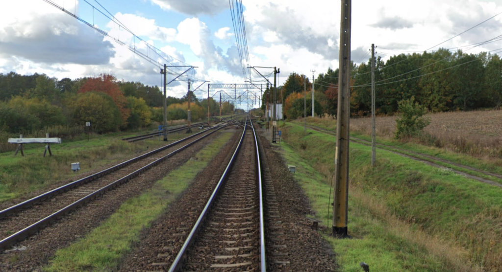
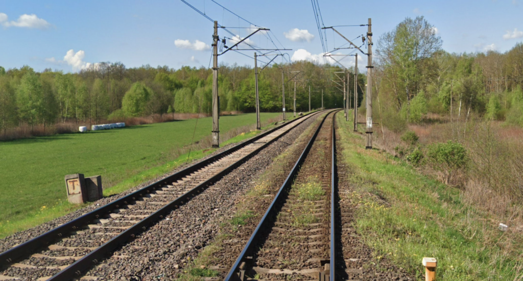
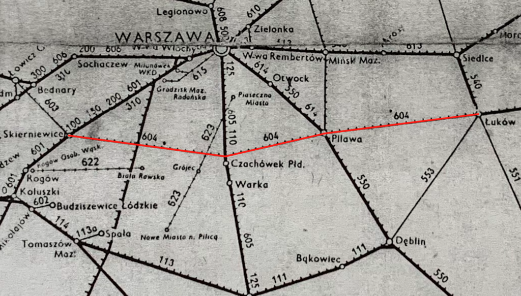
Railway line No. 12 Skierniewice – Łuków is also known as the Warsaw Freight Bypass. The line is electrified at 3 kV DC, double-track, and has a length of 161.567 km. It connects Skierniewice station with Łuków station, in the central-eastern part of the country. The line, commonly known as “S-Ł” or “Esełka,” runs through the Łódź Voivodeship, the Masovian Voivodeship, and the Lublin Voivodeship. The line runs longitudinally. The line is classified as a line of national and international importance, belonging to the AGTC network of international combined transport lines, as transport corridor C-E 20. Currently, the line is used almost exclusively for freight traffic, as the southern bypass of the Warsaw Railway Junction. The line constitutes a Warsaw bypass, intended for rail freight transport. Railway line No. 12 was launched: the Skierniewice – Pilawa section on October 3, 1954, and the Pilawa – Łuków section on May 23, 1954. The second track was launched between 1956 and 1962. The Skierniewice – Pilawa section was electrified on December 22, 1970, and the Pilawa – Łuków section on December 15, 1971. The track gauge is 1435 mm.
The S-Ł railway is a freight railway route of national importance. The construction of the line was clearly tailored to military needs, and importantly, not for the Polish Army, but for the Soviets. It was intended to provide east-west transport, bypassing the congested Warsaw junction. Dependence on Moscow meant the implementation of projects that did not meet Poland’s actual economic needs, but rather the military objectives of the Muscovite state. After World War II, the primary goal of the Polish State Railways (PKP) was to reconstruct the existing railway network, with the construction of new lines being secondary. An example is the reconstruction of the railway bridges in Tczew, after wartime destruction, which took place only in 1958. This is a crucial railway line between Warsaw and Porty. For the past 40 or 50 years, no new investments were made in the Łuków region, eastern Poland. The Skierniewice-Łuków railway line is the shortest latitudinal connection between Skierniewice and Łuków, and with extensions westward to Łowicz, Kutno, Poznań, and Słubice. It is the shortest railway route through Poland. Therefore, for military purposes, the line was highly useful and strategically important in the east-west direction. The line was constructed cost-effectively and quickly. The line was provisionally open as early as 1952, once the bridge over the Vistula River in Góra Kalwaria was completed. It should be remembered that the investments were made at the behest of the highest military authorities, i.e., at the behest of the then-functioning Ministry of Railways. These facts can be linked to the armed conflict in Korea, which was far from Poland. The line was not a main line due to its lack of appropriate parameters and low capacity. However, it was used for mass transit and military transport in the latitudinal direction.
The concept date for the Łuków-Skierniewice connection is unknown. In 1880, existing railway lines ran through Warsaw. The connection of the Vienna Railway and the Terespol Railway was a natural consequence. Moreover, these railways had different track gauges. However, the Soviets were very reluctant to create new connections. One example is the unrealized Warsaw-Wrocław connection, which was intensely lobbied by Germans. Furthermore, the Moscow state was focused, at that time, on building railway connections in Siberia, with the intention of connecting to the Pacific Ocean. It is logical to assume that the concept of the S-Ł line emerged just before the Great War. This was due to the heavy load on the Warsaw junction and limited possibilities for its improvement. It should be noted that experts cite dates of 1894 and 1897, when rail paralysis occurred in Warsaw. It is difficult to determine at this time how advanced the conceptual and design work on the new connection was. The plans certainly included a tangent station, with two gauges. There was also the concept of converting the Warsaw-Vienna Railway to broad gauge, a plan some researchers claim had already begun. However, the S-Ł line had not been implemented until the outbreak of World War II. In the Second Polish Republic, several new projects vital to the national economy needed to be completed: the Zagłębie Dąbrowskie-Gdynia coal line, and the Tarnowskie Góry-Wieluń-Kępno line. In Mazovia, the first line to be built was the Legionowo-Wieliszew-Tłuszcz line. A significant investment was the construction of the Nasielsk-Wieliszew-Legionowo line, which strategically bypassed the railway bridge over the Narew River in Modlin. This investment was opened on February 21, 1939.
On February 23, 1939, the Sejm (lower house of the Polish Republic) passed a law on the construction of the S-Ł line. This allowed for the commencement of design work and the taking out of loans for its construction. Some experts argue that this was a surprising decision. The Polish Army likely had the decisive say, and with the growing threat from Germans and Muscovites, the decision seems justified. The outbreak of war was rather exaggerated, although everyone dismissed the possibility. Remember, the foolish painter was already unbridled in his ambitions, and the agreement between the brothers, signed in Rapallo on April 16, 1922, was being implemented. The act of the Polish Sejm stipulated a 166 km long S-Ł line. Work on the line began even before the outbreak of World War II. Tendering procedures were completed, and contractors were selected.
During the initial period of the German occupation of Poland, they did not continue this investment. They focused on existing routes and the construction of freight bypasses, for example, around Kraków. The concept of the S-Ł line was revisited after World War II. In 1949, the decision was made to build it, and it began at a rapid pace. The work was led by the Directorate for State Railway Construction in Warsaw. The contractor was Przedsiębiorstwo Robót Kolejowych No. 1. The chief construction engineer was Zygmunt Piskorski, M.Sc., engineer. He worked on projects including the Kalety-Podzamcze line. Other engineers included Bolesław Chwaściński and Komosiński.
Not all the necessary geological work was completed, which hampered the excavation and drainage work during construction. The work was performed primarily by manpower, employing approximately 2,000 workers. A temporary narrow-gauge railway with rock-type wagons was used. Earth and rock material for the embankment at Góra Kalwaria were brought in from a distance of approximately 10 km. Diesel pumps were used to drain the excavations. In peat bog areas, holes were dug using explosives and filled with rock material. The entire construction took five years, although by 1952 the line was provisionally passable. A standard-gauge railway was used to bring in aggregate from quarries in the Sudetes. The greatest challenge was crossing the Vistula River, where, for geological reasons, the scope of work had to be significantly expanded. Near Tarczyn, the line was re-routed and laid alongside the Tarczynka River, significantly reducing the amount of earthworks. The track layout in Pilawa was also altered to avoid the need for a new railway station. Most engineering structures were constructed for a single track. Structures intended for two tracks were commissioned at two separate times, with each track being commissioned separately. Two railway viaducts for the S-Ł line, under the Vistula Railways line, were constructed after 1953. Finishing work, such as paving the level crossings, platforms, and additional sidings at the stations, were also completed later.
In October 1954, the official opening of the S-Ł “Esełka” line took place at Pilawa station. Representatives of party and state authorities from Warsaw and Piława attended the ceremony. Minister of Railways Ryszard Strzelecki presented state decorations. The “first” train also made its journey. The ceremony coincided with the anniversary of the Soviet October Revolution and the implementation of the “Six-Year Plan.” In reality, construction work was still underway at the time. In 1954, only the Mszczonów – Tarczyn section was double-track. On the remaining section, a second track was added in the early 1960s. Around 1965, a single-track connecting line was built near Pilawa; Jaźwiny – the Żołnierka branch line.
In the 1960s, passenger traffic on the S-Ł line was sparse, as it has been throughout history. It was primarily operated by SN52 and later SN61 series motor cars. After electrification, passenger traffic was taken over by EN57 series EMUs.
At the beginning of 1972, the Pilawa-Łuków section was electrified. On December 12, 1972, electrification of the entire S-Ł “Esełka” line, including the connecting roads, was completed. Electrification shortened passenger train travel time by one hour on the entire line and also increased the overall capacity of the line. Additional blocking posts were also built, which also increased capacity. All shape signals were replaced with light signals. Electrification resulted in the decommissioning of steam and diesel traction at the Skierniewice and Pilawski junctions. The Central Railway Main Line, built in the 1970s, intersected the S-Ł route approximately 2 km west of Mszczonów. On June 30, 1977, the single-track Szeliga-Marków link was opened. This was due to the lack of a section of the CMK from Szeliga to Grodzisk Mazowiecki, which was still under construction. Under this arrangement, trains from Silesia to Warsaw could only travel via the S-Ł route, and then via LK No. 8 Warka-Warsaw. These trains were diesel-powered, as the link had been electrified on December 23, 1977. The remaining links between the S-Ł “Esełka” and the CMK line were not built in the Mszczonów area.
On January 29, 1976, a railway accident occurred in Warszówka near Osieck. A Łuków-Skierniewice passenger train, operated by an EN57-1049 electric multiple unit, collided with a freight train. No one was killed, but 16 people were injured. On June 4, 1981, a railway disaster occurred. A Skierniewice-Łuków passenger train, operated by an EN57-1231 electric multiple unit, collided head-on with a freight train near Osieck. Twenty-five people died and eight were injured.
In the 1970s, track replacement became necessary. Track work lasted from 1978 to 1991. From the mid-1980s, passenger trains were reduced. In 2001, the last passenger train departed on the route, on the Skierniewice-Łuków route. On April 2, 2000, passenger traffic on this section was suspended. On August 3, 2004, PKP trains were suspended on the Pilawa-Łuków section. On December 12, 2008, Koleje Mazowieckie trains were suspended on the Pilawa-Łuków section. On June 1, 2010, Koleje Mazowieckie trains were suspended on the Góra Kalwaria-Pilawa section. Since then, only freight trains have operated on the route. Passenger trains on the Łuków – Pilawa – Łuków route briefly returned in the 2007-2008 timetable, with connections operated by SA134 DMUs. The Vltava Bis train also ran from 2011 to 2015. In September 2014, the interREGIO train “Bug” was introduced on the Poznań Główny – Terespol route, running on Fridays and Sundays. After a few weeks, this train was diverted to LK No. 2 and left the S-Ł line.
In 1989, socio-economic changes took place in Poland. As a result, the Warsaw Pact was dissolved. The S-Ł route, as a CCCP-GDR military route, lost its significance in 1992, when Moscow’s troops were withdrawn from the GDR and Poland.
In the following years, several significant investments were not completed. The second bridge over the Vistula River, for the second track, was never built. The condition of the second track on the Puszcza Mariańska – Mszczonów section has deteriorated, and traffic is limited to one track. Signal boxes and block posts have been removed. Block posts were removed at Gąski, Grzegorzewice, Grabce, Kamion, and, in early 2000, at Prażmów and Jeżewice. In 2007, Jedlanka station became a passenger stop, and in 2008, the same happened at Czachówek Wschodni station.
Currently (January 2026) passenger trains only reach the following stations: Góry Kalwaria (Mazowieckie Railways, to Warsaw, 15 pairs per 24-hour). Pilawa railway station (On January 2, 2026, 79 trains departed from Pilawa station to the following stations: Bydgoszcz Główna, Chełm, Dęblin, Frankfurt/Oder, Gorzów Wielkopolski, Grodzisk Mazowiecki, Hrubieszów Miasto, Jagodin, Kołobrzeg, Lublin Główny, Piła Główna, Poznań Główny, Rava Ruskaia I, Rzeszów Główny, Sobolew, Sochaczew, Szczecin Główny, Świnoujście, Warszawa Zachodnia, Zielona Góra Główna, Żyrardów). Łuków Railway Station (On January 2, 2026, 45 trains departed from Łuków Station to the following stations: Chełm, Lublin Główny, Siedlce, Terespol, Warszawa Służewiec, Warszawa Wschodnia, Warszawa Zachodnia, and Żyrardów). There are no passenger trains on the Łuków – Pilawa route, and connections from one city to the other are only possible with transfers. Currently (2026), there are no regular passenger trains running along the entire length of Railway Line No. 12 Skierniewice – Łuków.
Railway Line No. 12 Skierniewice – Łuków.
Skierniewice station (0.00 km, elevation 124 m). Other Railway Lines No. 1, 11, 529, 558. Local Control Center. The viaduct of national road No. 70 passes over the platforms. Skierniewice junction R402, local road No. 558. The line passes Bohaterów Westerplatte Street, then Pilot Romualda Sumińskiego Street. The line crosses the Rawka River on a truss bridge. This is the Skierniewice city limit. The line runs through forests. There is a forest level crossing. The line crosses the border between the Łódź and Masovian Voivodeships. There is another forest level crossing.
The line runs through agricultural land. There is a railway crossing on a local road. There was a railway stop here. Długiógyny was a passenger stop (km 10.04, elevation 124 m). Puszcza Mariańska station (km 13.73, elevation 135 m). Next to the station is an operating fuel depot. Behind the station, the line runs under DW No. 719. Further on, there is a railway crossing, Króla Jana Sobieskiego Street. There is a forest road crossing. Another crossing is in Nowa Huta, and the next in Wólka Więcka. The village of Grabce Wręckie; here the line runs under Pałacowa Street. Grabce was a passenger stop (km 19.86, elevation 158 m). Then there is a crossing, Brzozowa Street. Line No. 12 passes over the CMK line. Marków junction (24.65 km, elevation 171 m), line No. 575 m. The line passes under the S8 motorway and then under a local road; Rawska Street. Next, Piekarska Street passes under the tracks. Mszczonów station (26.19 km, elevation 172 m). At Mszczonów station, there are six through tracks and a large storage yard. The island platform is overgrown with grass. Behind the station is the Grójecka Street viaduct, and there were also two sidings northbound to industrial plants. Further on, there is a railway crossing along Lipowa Street and another along Brzozowa Street. At this point, the siding switches northbound to a huge passenger car lot, operated by CAT Mosolf Polska in Ciemno Gnojna. To the south of the line is the Grupa Pekabex plant, which produces precast concrete. The line passes under national road No. 50. The line then crosses the Pisia River. There are three forest road crossings. Then the line runs under the Słoneczna Street viaduct. In Grzegorzewice, there was a passenger stop (km 34.58, elevation 172 m). At this point, there is a crossing along Mszczonowska Street; national road No. 876. Then there is a crossing along Piaskowa Street. Then the line passes under Przejazdowa Street. There is a crossing along a local road. There is a crossing along Graniczna Street, near the SIGMA scaffolding factory. Then there is a crossing along Długa Street, then another crossing; Wspólna Street. In Jeżewice, there was a passenger stop (km 41.59, elevation 174 m). At the stop, there is a crossing along Szkolna Street. Then there is a crossing along Kolejowa Street. Here, there are agricultural areas. The line turns slightly right (southeast) and re-enters the forest. The line passes over Wspólna/Dolna Street. The line crosses the Tarczynka River. There’s a forest road crossing, Warszawska Street. The line passes over the forest road; Spacerowa Street. The line curves slightly to the left (northeast). The line passes over Wiaduktowa Street.
Tarczyn station (km 47.96, elevation 153 m). There are 7 through tracks here. The island platform is overgrown. The single-story station with a usable attic is in good condition. Behind the station, the line passes under national road No. 7. The line again makes a slight curve to the right (southeast). There is an underpass along a local road; Leśna Street. On the north side, there is a concrete plant. The line runs over the S7 motorway. There is an underpass along Południowa Street. Gąski was a passenger stop (km 52.57, elevation 135 m). There is an underpass along Kolejowa Street. The line passes through fields, wasteland, and forests. There is an underpass along a forest road; Główna Street. The line crosses the Jeziorka River. Prażmów was a passenger stop (km 58.26, elevation 124 m). The line crosses national road No. 722 at the foot of Główna Street. There’s a level crossing along Leśna Street, and then there’s a crossing along Główna Street and DW No. 683 (Main Street). The line turns slightly left again. There’s a DW No. 683 railway crossing. Czachówek Western branch line (64.34 km, elevation 114 m), railway lines No. 526, 528. Czachówek Middle passenger stop (65.26 km, elevation 114 m), intersection with LK No. 8. LK No. 12 passes under LK No. 8. Both lines have all four connecting roads, allowing travel in either direction. The line crosses the Czarna River. Czachówek Wschodni junction and passenger stop (67.12 km, elevation 115 m), railway lines No. 525, 527. Currently, in 2026, the stop is operated by Koleje Mazowieckie on the Warszawa Gdańska – Czachówek Wschodni – Góra Kalwaria route. There are 13 pairs of trains here daily. The stop has an island platform. Before the platform, a local road passes under the tracks. After the station, the line passes under Szkolna Street. Further on, the line passes under national road No. 79. The level crossing before the viaduct has been removed.
Góra Kalwaria station (km 73.51, elevation 105 m). Góra Kalwaria is a small station with an island platform. The station organizes traffic before trains enter the single-track railway bridge over the Vistula River. The line passes under Pijarska Street. The line then passes under Kardynała Stefana Wyszyńskiego Street. Lipkowska Street also passes under the track. The railway bridge over the Vistula River has six truss spans and a short span on the right bank above a local road. The bridge pillars are adapted to accommodate additional spans for the second track. The spans are steel and riveted. On the right bank is the Kępa Gliniecka junction (km 76.50, elevation 95 m). Here, once again, the single track becomes double track via a switch. At the same time, the line curves directly east. The line passes over national road No. 50. The line runs through farmland. There is a crossing along national road No. 801. There is also a crossing along the local road and another in the village of Warszówka. Warszówka was a passenger stop (km 81.66, elevation 94 m). The line enters the forest. The line uses a viaduct to cross a sandy forest road. The line passes under national road No. 862, Przemysłowa Street. There is another crossing along the local road. Osieck station (km 89.02, elevation 122 m). This is a small freight station with an overgrown island platform. The station is a single-story building with a usable attic. There are four through tracks, but there used to be more. Behind the station, there is a crossing along the local road. The line passes under the local road. Next to the viaduct is national road No. 805 and the Monument to the Victims of the Osieck Railway Disaster. There is a crossing along the local road. The line passes under a local road. There is another viaduct on the local road, which is closed with barriers due to its poor technical condition. Further on, there is a crossing on the local road. The Jaźwiny passenger stop is closed (km 95.54, elevation 145 m). The Jaźwiny branch station (km 96.40, elevation 146 m), line no. 524. One track turns northward, and two more tracks turn southward to Pilawa station. All these tracks pass under another double-track railway line. Two tracks of LK No. 12 join the single-track line running from the north. There is a local road crossing, now within the Pilawa town limits.
Pilawa station (km 99.28, elevation 151 m), other lines No. 7 and 13. Pilawa station is an important railway junction, connecting railway lines from five directions. Just beyond the city limits, LK No. 12 from the north turns left towards the east. The tracks have concrete sleepers, but they are in average condition. The line re-enters the forest. The line passes over the S17 motorway at an elevated level. Next, there is a crossing on Stacyjna Street and then three more crossings. Huta Czechy was a passenger stop (km 104.62, elevation 150 m). The line curves slightly to the left. Parysów was a passenger stop and a station (km 110.66, elevation 154 m). The station had four through tracks. The island platform is overgrown. The station building, single-story with a usable attic, has survived. After the Parysów station, there’s a level crossing on DW No. 805. The line again makes a slight right turn to the east. The line continues through forests and wasteland. Further on, there’s a forest road crossing and another crossing on Biela Street and another on Waltera Nurzyńskiego Street, the village of Jaźwiny. There’s another local road crossing. Chromin is a former passenger stop (km 118.23, elevation 155 m). Two single-edge platforms are overgrown. There’s another local road crossing, between the platforms. Further on, a local road passes under the line. The line crosses a local river. Further on, a local road crossing. The line enters farmland. There’s another crossing. Further on, the line passes under a local road. The line enters the forest and makes a slight curve to the right. Iwowe is a former passenger stop (km 124.18, elevation 178 m). Two single-edge platforms remain, but are overgrown. There’s a level crossing and former railway buildings.
The line crosses the border between the Masovian Voivodeship and the Lublin Voivodeship. The line crosses a local road at the bottom and then a dirt road at the top. Stoczek Łukowski freight station (km 130.13, elevation 180 m). The station is located approximately 800 m south of the town center. Currently, the station has four through tracks and an island platform. The single-story station building is disused. The property is available for rent. The platform still features streetlights. There is a signal box, warehouse, ramp, and storage yard. Behind the station, Generała Dwernickiego Street passes under the tracks. The line then passes through forests and slightly curves right. Wiejska Street and the Świder River pass under the line. The viaduct was recently renovated. Next, there is the crossing of the national road No. 76, Piłsudskiego Street. The line curves slightly left and enters farmland. There are three crossings for dirt roads. Kobiałki, a former passenger stop (km 136.16, elevation 174 m), has preserved platforms and a dirt road level crossing. A residential building, presumably a former railway building, also stands. Further on, the line crosses the Świder River. The line then passes under national road no. 67. At this point, the line curves slightly left and right. Next, there is a crossing, Chrusty Street. There are two dirt road crossings. Jedlanka, a former passenger stop, was a station (km 141.66, elevation 176 m). The station is a single-story building with a converted attic, intended for rental purposes. There are switches and unused side tracks here. The island platform has been demolished. Behind the station, there is a crossing along a forest road, in a small forest. Further on, there are three dirt road crossings. Żdżary, a former passenger stop (km 147.94, elevation 170 m), has overgrown platforms, a crossing, and residential and farm buildings, presumably former railway buildings. Further along is a crossing along a local road. Krzna is a former passenger stop (km 153.78, elevation 165 m). The platforms, a level crossing, and an abandoned former station building from the 1970s have survived. Further along are three level crossings along local roads. Zimna Woda is a junction and crossing along Szlak Powstańców Styczniowych Street. Here, a connecting line branches off to the left northbound to LK No. 2 Warszawa Zachodnia – Terespol. This connecting line allows trains to bypass Łuków station and head towards Warsaw. Łuków station (km 160.10, elevation 166 m), other railway lines No. 2, 26, 30, and 523.
Written by Karol Placha Hetman