
Pilawa 2025-07-21
Railway line No. 13 (Krusze) Tłuszcz – Pilawa, No. 29 Tłuszcz – Ostrołęka.
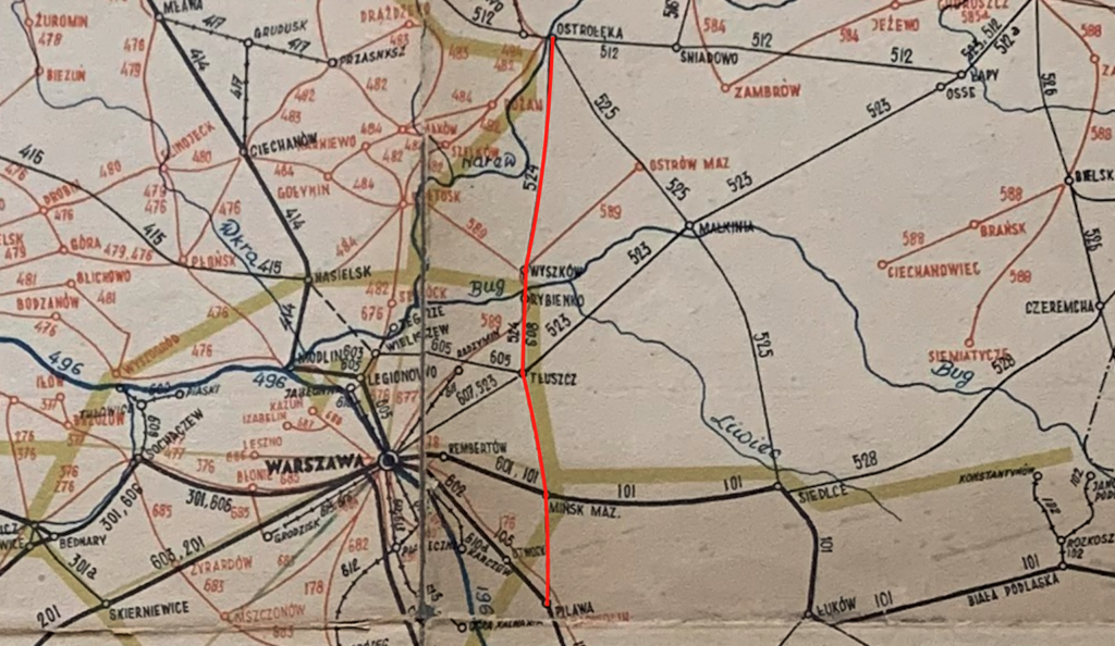
The Pilawa – Tłuszcz – Ostrołęka railway line was launched in 1897, when Poland was under partition, and most of the former Polish-Lithuanian Commonwealth was under the Muscovite partition and formed a fictitious state: the Kingdom of Poland. This route was created for very specific, strategic reasons. The main impetus was the need to build a line bypassing Warsaw, which lay deep within the Kingdom of Poland. The Muscovites desired an alternative rail route for transporting troops, equipment, and supplies from the Muscovite hinterland to the western borders of the empire. The line was intended to enable the rapid movement of troops without passing through Warsaw, which, in the eyes of the Muscovites, was considered disloyal and potentially hostile in the event of a war, uprising, or other conflict. While in the interior of the empire, lines were built in a star-shaped pattern from Moscow and St. Petersburg, in the western parts, near the borders with the Prussian and Austrian brothers, the lines were mainly laid meridianally. It was unknown where a specific threat would arise. The line allowed for the connection of several fortresses and military garrisons in the western part of the empire. The second purpose was to create a base for potential fronts in the event of a war with the Prussian brothers or Austria-Hungary. The route was known as a circumferential railway: Dęblin – Pilawa – Tłuszcz – Ostrołęka – Łapy, completely bypassing Warsaw on both the eastern and northern sides. Thus, the first railway network in Poland was created, allowing for alternative routes.
As usual, economic objectives were not considered. The route ran through the less developed areas of Mazovia and Podlasie, stimulating the development of local trade, crafts, forestry, and agriculture. The railway enabled the transport of timber, agricultural produce, and construction materials from the Ostrołęka and Kurpie regions. With a weak and sparse road network, the railway became the primary means of transportation. Unexpectedly, the city of Ostrołęka became a major railway junction. Due to the outbreak of the Great World War, the line failed to demonstrate its full potential.
Timeline: Around 1896, the tsarist authorities decided to build a section of the Pilawa-Tłuszcz-Ostrołęka railway line. On October 13, 1897, the line opened, despite not having completed all the work. Between 1897 and 1903, the basic sections, stations, and bridges were constructed. In 1903, regular freight and passenger traffic began. During the period 1914-1918, the route was intensively used by Muscovites, and later by Germans and Austrians. Already during the Second Polish Republic (1918-1939), the line was systematically modernized and expanded, with the construction of further sidings to industrial plants. During the period 1945-2000, passenger traffic remained moderate, but there was very high freight traffic (raw materials and finished goods). Between 2015 and 2025, the route underwent extensive modernization and adaptation to changing transport needs (increased freight train tonnage, increased speed, and significant improvements to the SRK system).
Currently (2025), this route is an important regional route operated primarily by Koleje Mazowieckie. The Pilawa – Mińsk Mazowiecki section is used by long-distance trains on the Lublin – Warsaw route, bypassing the overloaded LK No. 7. For freight traffic, it is a crucial corridor for the transport of timber, aggregates, agricultural goods, and industrial machinery and equipment. Despite the passage of time, the line remains useful as a detour from Warsaw in the event of breakdowns or work on the main railway routes. The line serves vital Polish interests, extending northwards from Finland to Bulgaria. Modernization work has been underway since 2015: PKP PLK has been carrying out track repairs and replacements, particularly on the Pilawa – Tłuszcz section; Line speeds and safety at level crossings have been increased.
Currently, the Ostrołęka-Pilawa railway line does not exist as a single, coherent railway line. Railway line No. 29 Ostrołęka-Tłuszcz and railway line No. 13 Krusze-Pilawa are connected but do not form a single line, and the section between Mińsk Mazowiecki and Pilawa serves freight and long-distance passenger trains.
Railway Line No. 13 Krusze – Pilawa.
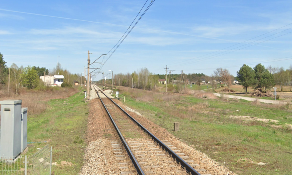
The Krusze – Pilawa Railway Line No. 13 is single-track and electrified. It was opened on October 13, 1897, originally for the Moscow Railways (PRŻD). Railway Line No. 13 is 56.604 km long. The rail gauge is 1435 mm. In 1945, the line was impassable. It reopened around 1950. The overhead line is 3 kV DC. Maximum speed is 100 km/h. Electrification was completed in 1970 (Kędzierak – Pilawa), and on May 27, 1972 (Krusze – Kędzierak, including connecting line No. 513). This allowed electric trains to run along the entire line.
During the communist era, due to insufficient maintenance, train speeds were gradually reduced. First, it was increased to 60 km/h, and then sectional speeds were increased to 40 km/h. The first revitalization work was carried out in 2020 by PNUIK Kraków. On March 31, 2022, a tender for track renovation on the Krusze – Pustelnik section was awarded, increasing speeds from 60 to 100 km/h. On February 14, 2025, a tender for track renovation on the Mińsk Mazowiecki – Sufczyn section was announced.
The Mińsk Mazowiecki – Pilawa section of line No. 13 is used by express and international PKP InterCity trains to bypass the congested line No. 7 on the Warszawa Wschodnia – Pilawa section. This section is mainly used by trains on the Warsaw – Lublin route.
Railway Line No. 29 Tłuszcz – Ostrołęka.
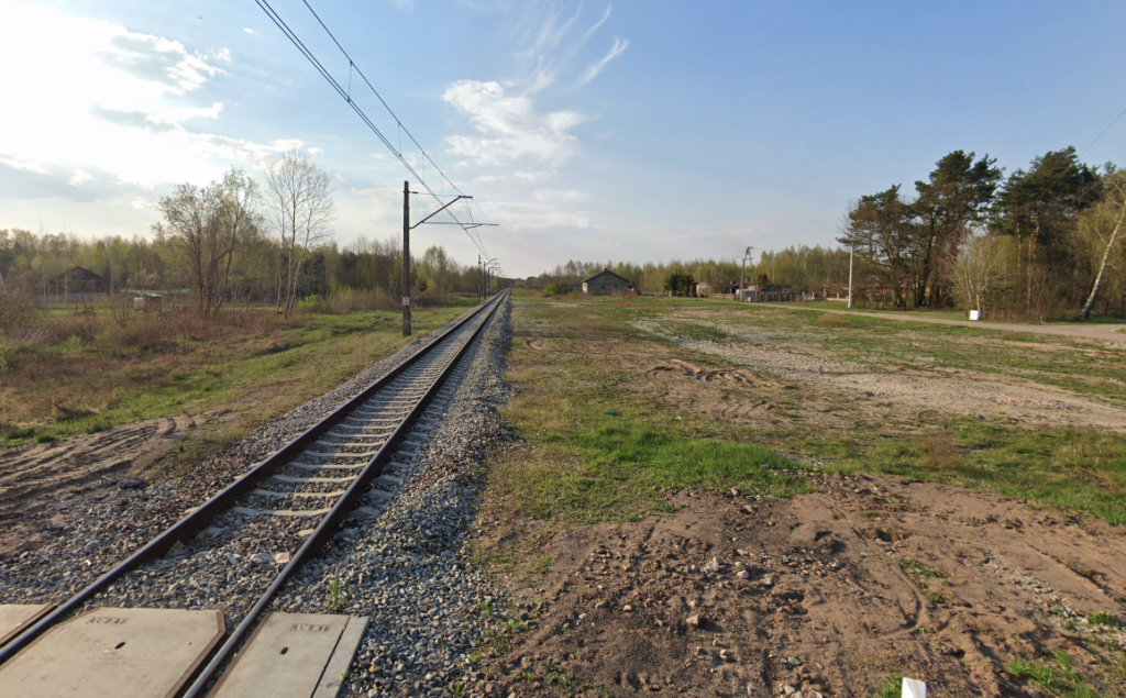
The Ostrołęka – Tłuszcz Railway Line No. 29 is single-track and electrified. The line opened on October 13, 1897. The line was incorporated into the Warsaw-Terespol Railway. The history of Railway Line No. 29 is interesting. It was the site of three railway bridge blowouts in Wyszków and several train accidents. As you might imagine, head-on collisions, the most tragic of which occurred in 1941, between a German passenger train on the Königsberg – Warsaw route and a freight train. In 1945, due to the destruction of a bridge over the Bug River on the Rybeńko – Wyszków section, the line was impassable.
Railway Line No. 29 Tłuszcz – Ostrołęka is an electrified, single-track, first-class railway line of national significance, 76.046 km long. There are 7 railway stations and 9 passenger stops along its route. The line was opened on October 13, 1897. The rail gauge is 1435 mm. Electrification is 3 kV DC. Maximum speed is 100 km/h. Electrification: 1982 (Tłuszcz – Wyszków), 1985 (Wyszków – Ostrołęka). Currently (2025), regional trains of Koleje Mazowieckie and the Ostrołęka – Warszawa Wileńska express train run along the route. From Wyszków, you can travel to the following stations: Łowicz Główny, Ostrołęka (14 pairs of trains per 24 hours), Tłuszcz (14 pairs of trains per 24 hours), Warszawa Wileńska (2 pairs of trains per 24 hours).
Unfortunately, this part of Mazovia is not attractive to tourists. The few museums are run by enthusiasts, without significant support from the Mazovian Voivodeship authorities. Between Rybienko and Wyszków stations, the train passes over a railway bridge over the Bug River, a major attraction on this line. Wyszków has a population of 26,019 (2023). There are few historical monuments in the city. In the center, it’s worth seeing the Church of St. Giles with its historic rectory and the gatehouse in Bishop Karol Ferdynand Vasa Park. On the outskirts of town, overlooking the Bug River, stands the Skarżyński Palace with its park, built around 1780. Privately owned, located in the village of Leszczydół. In the nearby forests lies the so-called Uprising Line, a clearing in the forest that hindered the insurgents during the January Uprising. Its existence is commemorated by plaques and a chapel. A 19th-century manor house is located 3 kilometers north of the Pasieki station in the village of Ponikiew Mała. Goworowo is also home to a palace converted into a hotel. Four kilometers east of Goworowo is the Marchwicki Palace in Brzeźno, which is privately owned. Almost every village has a historic church, often wooden or with a wooden bell tower. The area is home to numerous roadside shrines.
Ostrołęka is a city in the Masovian Voivodeship, located on the Narew River, approximately 120 km northeast of Warsaw. It currently has a population of approximately 51,000. It is known for its rich history, particularly the Battle of Ostrołęka in 1831, which took place during the November Uprising. The city is a strong center of the energy, pulp and paper, and construction industries. It is a regional cultural center for the Kurpie region, hosting numerous festivals and folklore events. The Ostrołęka Power Plant operated in the area. The city is the county seat and was formerly the seat of the voivodeship.
Line No. 29 serves both passenger and freight traffic. The line begins at Tłuszcz station, connecting with railway line No. 6 (E75 Rail Baltica) and line No. 10 Legionowo-Tłuszcz, among others. It then heads north, passing through Wyszków, among other places. In Ostrołęka, it connects with lines No. 34 Ostrołęka-Małkinia, No. 36 Ostrołęka-Łapy, and No. 37 Ostrołęka-Szczytno, among others. Freight traffic dominates the line. The line’s most important customer is the Ostrołęka Power Plant (Elektrownia Ostrołęka S.A.). The line is of regional importance for passenger traffic, providing a connection between northeastern Mazovia and the Warsaw metropolitan area. During the communist era, train speeds were systematically reduced due to a lack of maintenance. Due to the projected increase in transport needs for Elektrownia Ostrołęka S.A., revitalization work is planned. Ultimately, it is planned to achieve technical parameters enabling passenger traffic at speeds of up to 100 km/h (Tłuszcz – Wyszków section) and 120 km/h (Wyszków – Ostrołęka section).
In February 2024, a series of meetings were held between PKP PLK representatives and municipal authorities and residents regarding the “Modernization of Railway Line No. 29 on the Tłuszcz – Ostrołęka section.” Consultations were underway as part of the “Preparatory Work for Selected Projects” program. These included adjusting the location or constructing new passenger stops, in accordance with residents’ wishes. The project also included the construction of grade-separated rail-road intersections. Construction of footbridges and pedestrian and cyclist crossings was also considered. Modernization of passenger stops was planned at Czarnowiec, Żabno, Borowo, and Wyszków Miasto. There are plans to rebuild Dalekie station.
The plans are ambitious. They include the construction of a second track, adapting the line to passenger train speeds of up to 200 km/h, and constructing new stops. Importantly, PKP PLK is considering at least two variants of the line’s improvements. Depending on the variant, the speed is to increase to 160 km/h or 200 km/h. The modernization of the freight station in Wyszków will extend the tracks to a minimum of 750 meters. This project depends on the local government’s requirements and financial resources. Detailed plans will be developed after consultations and analyses are completed. The project will be implemented using a design-build system.
The route of railway lines No. 13 Krusze – Pilawa and No. 29 Ostrołęka – Tłuszcz.
So we’re heading south; Krusze – Pilawa.
Kursze station, checkpoint, passing loop (0.00 km, elevation 102 m). Line No. 10 is here. Kursze R7 junction (3.03 km, elevation 108 m) is the beginning of line No. 513. Kursze is a small station where line No. 10 gives rise to line No. 13. The line from the east turns south. Both lines are single-track. Line No. 13 crosses the Cienka River. Further on, a connecting road from Tłuszcz station joins the line from the east. In the village of Jasienica, line No. 13 crosses the double-track Rail Baltica railway line on the Warsaw – Białystok section. Further on, line No. 13 crosses the local Lipowa Street and the next Wołomińska Street at an intersection. The line runs through farmland and small forests. It then crosses the DW No. 634 intersection, Jutrzenki Street, and the village of Karolew.
Dąbrowica is a passing loop (9.74 km, elevation 111 m). Next, the line crosses Szkolna Street at a local road. Then, the line crosses Rządza River. In Rojków, the line crosses a local road at a crossroads.
Pustelnik is a passing loop (19.77 km, elevation 134 m). After the passing loop, the line crosses Osiedlowa Street at a local road. It then crosses the Czarna River. Next, there is an intersection with a local road, the village of Goździówka. Next, there is an intersection with a local road, Wspólna Street, the village of Cyganka Północna. And another intersection, Gościnna Street, the village of Cyganka. There is a church nearby. The line crosses the Długa River. Then, the line passes the A2 motorway, the Freedom Highway, at the bottom. Nearby is a road junction connecting the A2 motorway, National Road No. 50, and Mińsk Mazowiecki. The line then passes National Road No. 50 at the bottom.
Arynów used to be a passing loop (29.50 km, elevation 155 m). Already in Mińsk Mazowiecki, the line crosses National Road No. 92, Warszawska Street. Then, at the top, the line crosses the double-track Warsaw-Mińsk Mazowiecki-Siedlce line, No. 2. Further east is the ZNTK Mińsk Mazowiecki railway station, owned by PESA Bydgoszcz.
Mińsk Mazowiecki junctions R101/102 (32.60 km, elevation 149 m). Railway lines (switching lines) 521 and 522. A connecting line from Line No. 2 runs from the left and right. Further on, the line crosses a local road via a viaduct and leaves the Mińsk Mazowiecki city limits. The line then crosses the Mienia River. Further on there is an intersection with a local road and further intersections; two local roads.
Grzebowilk station (km 34.887, elevation 150 m). This is a typical freight station. The station has five through tracks and a “Gb” signal box. Behind the station is an intersection along Kolejowa Street. Further on, there is an intersection along Mazowiecka Street. This intersection is more forest than farmland. Next comes the intersection along Pałacowa Street, the village of Nowe Rudno. Then comes another intersection, Siennicka Street.
Kołbiel, a former passenger stop (km 44.10, elevation 124 mm). Further intersections follow: Kołbielska and Spacerowa Streets. The line crosses the Świder River. Here is the Świder Nature Reserve. The bridge is made of iron, plate girder, and designed for two tracks. Vehicular traffic is permitted at the location of the second track. The bridge was named “Żelaźnika.” The line then crosses Strażacka Street at an elevated level.
Sufczyn station (km 47.61, elevation 130 m). The station has three through tracks and a loading yard designated for the bridge base. The “Su” signal box is located here. Further downstream, the line crosses the S17 motorway. Sufczyn branch line (km 52.07, elevation 147 m). Line No. 13a.
The line has reached the Pilawa railway junction. Jaźwiny R11 junction (km 53.77, elevation 148 m). Railway line No. 524. Here, line No. 13 connects with the double-track “Esełka” line from Góra Kalwaria (No. 12). It then connects with the double-track line from Otwock (No. 7).
Pilawa station (km 56.33, elevation 151 m). Railway lines No. 7 and 12. Pilawa is located in Garwolin County, approximately 59 km southeast of Warsaw, on the Garwolin Plain. The town has an area of 6.62 km² and a population of 4,300. It boasts railway monuments dating back to the late 19th century: a wooden station from 1877, a locomotive shed, and a water tower. The station has two platforms and four platform edges. At the station, there is an intersection with DW No. 805, Aleja Wyzwolenia.
Then we continue from Tłuszcz to Ostrołęka, heading north.
Tłuszcz station (0.00 km, elevation 104 m). Lines 6, 10, and 513 are located here. The Local Control Center (LCS) is located here. The town of Tłuszcz is located in Wołomin County, Masovian Voivodeship, approximately 35 km northeast of Warsaw. It is a town and the seat of an urban-rural commune (status since 1967). Town rights were granted in 1967. The town has an area of approximately 7.9 km². The town has a population of approximately 8,000. The railway station was built in 1862. Currently, the station has three platforms and six tracks. Access to the platforms is through a tunnel. Previously, there was a footbridge over the tracks. In the western part of the station, the viaduct DW No. 634 runs over the tracks. In the western part of the station is a cemetery commemorating the fallen defenders of the Homeland from 1920. There’s a historic water tower here. The station dates back to the 1960s. A rolling stock repair and maintenance facility is located in the eastern part of Tłuszcz station. Line No. 29, leaving the station, turns left northward as a single-track line. The line then crosses DW No. 636 at a junction, Jadowska Street.
Jarzębia Łąka passenger stop (km 3.45, elevation 103 m). After the stop, there’s an intersection with Długa Street. Further on, there’s an intersection with Kolejowa Street and another intersection, Osiedlowa Street.
Grzegorzewo passenger stop (km 6.75, elevation 96 m). Before the platform, there’s an intersection with Świętego Huberta Street. Further on, there’s an intersection with Oliwkowa Street and another intersection, Władysława Reymonta Street, in the village of Zabrodzie. The line crosses the Szewa River.
Mostówka station (10.75 km, elevation 93 m). The station has two single-edge platforms and three through tracks. A railway siding leads from the station to the Stark Log and Granit Skwara plants. The station is served by the “Mt” signal box, which controls the level crossing along Kolejowa Street. The line then enters forested areas.
Lucynów passenger stop (km 14.72, elevation 91 m). Behind the platform is an intersection at Warszawska Street. The line then runs under the S8 Via Baltica motorway. The line crosses the intersection at Wspólna Street. The line then crosses the Ruda River.
Rybienko passenger stop (km 18.04, elevation 91 m). Before the platform is an intersection at Aleja Wolności Street.
Railway bridge over the Bug River in Wyszków. The first bridge was built between 1895 and 1897 by the company “K. Rudzki i S-ka.” It was an impressive structure, approximately 470 m long. The bridge consisted of seven spans: six truss spans with a roadway above, and one plate girder span with a roadway above. The bridge was supported by stone piers. The bridge was rebuilt between 1905 and 1910. The bridge was destroyed in 1915. Thirty years later, it was rebuilt. During World War II, in 1939, Polish sappers destroyed three spans, which were rebuilt by the Germans. In 1944, the Germans, fleeing from their Muscovite brethren, destroyed all the spans and destroyed the piers. The bridge was temporarily rebuilt until 1948. Full renovations were completed by 1957. Currently, the bridge has four long riveted truss spans with a roadway below, and two short plate girder spans on the abutments. The piers are made of stone and concrete. Currently (2025), the train speed limit on the bridge is 40 km/h. The bridge is scheduled for renovation and will likely receive completely new spans. The area around the bridge is a popular place for walkers.
Wyszków station (20.57 km, elevation 101 m). Wyszków is a historic town with over 800 years of tradition, with a population of approximately 26,000. Closely connected to the Bug River and the Forest, it is an important railway and transport hub, with monuments dating back to the 18th and 19th centuries. Monuments: the classicist palace in Rybienko Stary (late 18th century), St. Giles’ Church from 1793, and the Vasa obelisk. Before the station, the line crosses the intersection of 3 Maja Street, Serocka Street (DK No. 62, below), and Pułtuska Street (DW 618). The station has two platforms and three platform edges. Access to the platforms is via a footbridge over the tracks. In the northern part of the station, there is a siding to the PEC Wyszków plant, the “Wz” signal box, and a viaduct over the tracks along Henryka Sienkiewicza Street. On the outskirts of the city, the line crosses Świętojańska Street. The line enters the forests.
Leszczydół passenger stop (25.79 km, elevation 116 m). Behind the stop is an intersection on Środkowa Street. And again, there are forests.
The far section is a passenger stop and a cargo hold. (30.14 km, elevation 112 m). The village of Dalekie was founded on the timber industry. There is a large sawmill and a cardboard packaging factory here. Additionally, there is a residential area called Dalekie Tartak. Behind the village is an intersection, Modrzewiowa Street.
Zygmuntowo Mazowieckie passenger stop (km 35.57, elevation 108 m). This is a village with scattered buildings nestled among fields and forests. Further on, there are two local road intersections. Then the line crosses the Struga River.
Przetycz station (km 50.20, elevation 95 m). In reality, this is a passing loop. There are two single-edge platforms. Behind the station is an intersection on Główna Street. The line crosses the Wymakracz River. And again, the line runs through forests.
Prabuty Góry passenger stop (km 44.88, elevation 98 m). Before the stop, the line crosses Kolejowa Street at an intersection. The line continues through forests.
Pasieki station (km 50.20, elevation 111 m). The station has two platforms and three platform edges. Behind the station is an intersection on Szkolna Street. Farmland begins. Further on, the line passes under DW No. 60 and 61. The line then crosses the Czerna River. Further on, there are intersections with local roads. The line then crosses the Orz River.
Goworowo passenger stop (km 58.26, elevation 108 m). There is one platform and one platform edge. A traction substation is located at the stop. Goworowo is a typically agricultural village. The line crosses local roads.
Gierwaty station (km 66.57, elevation 102 m). There is an island platform and two platform edges. The “Gr” signal box is located here. Further on, there are four intersections with local roads. The line reaches Ostrołęka. From the east, a single-track railway line from Ostrów Mazowiecka station joins. The lines cross Kolejowa Street at an intersection. Already within the Ostrołęka station area, a railway line from the Szczytno direction joins from the west.
Ostrołęka station (74.23 km, elevation 106 m). The station is approximately 5 km south of the city center. Railway lines 34, 35, 36, and 900 are located here. There is a local railway control (LCS) here. The station has two platforms and four platform edges. There is a footbridge over the tracks. Platform 1 is 362 m long, and Platform 2 is 291 m long. The station was opened in 1893, when a line was added from the east, from Łapy station. During the Great War, the Muscovites destroyed the station, which was rebuilt by the Germans. This included the locomotive shed and the water tower. The last major renovation of the station was completed in 2023. A new platform was built. Platform 1 remained with a trilined surface. The freight section was renovated. The station has been renovated, including a library, waiting room, and restrooms. A footbridge over the tracks has been retained. In front of the station, in the park, stands a technical monument: a Px48-1758 narrow-gauge steam locomotive.
Written by Karol Placha Hetman